Strong, Cold Inside Slider for Tuesday
More heavy snow coming to the Sierra tonight through Tuesday when an inside slider drops down from Oregon. The models are in agreement that the Sierra will pick up an additional 1-2 feet of snow. The NWS service has posted winter storm warnings for the entire Lake Tahoe Area. With this storm comes a very cold, Arctic air mass that should bring some of the coldest temps we have seen in quite some time to the area. Especially the valley floors. The cold air will be trapped by the sourrounding mountains as a high pressure ridge moves in for Wednesday-Friday. This will cause temperature inversions. The lowest parts of the valley will see below zero temperatures on Wednesday night.
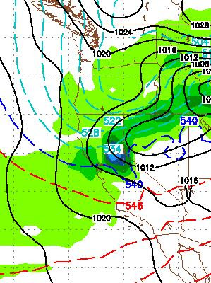
Here is a GFS look for Tuesday late morning:
It is my understanding that the good folks up at Mt. Rose are working very hard to open the NW lift in time for Thanksgiving. With the new snow on the way through Tuesday, I am guessing that Rose will be open top to bottom on the Rose side for Thanksgiving, so get up there and burn some calories ahead of the eating frenzy on Thursday night!
Another storm is coming this weekend that has the potential to mess up the Thanksgiving return trip. I will talk about that later today or tomorrow.
Stay tuned ...
Here is a GFS look for Tuesday late morning:

It is my understanding that the good folks up at Mt. Rose are working very hard to open the NW lift in time for Thanksgiving. With the new snow on the way through Tuesday, I am guessing that Rose will be open top to bottom on the Rose side for Thanksgiving, so get up there and burn some calories ahead of the eating frenzy on Thursday night!
Another storm is coming this weekend that has the potential to mess up the Thanksgiving return trip. I will talk about that later today or tomorrow.
Stay tuned ...