Posts

Showing posts from November, 2011

Two Highs Become One, Dominate Our Weather

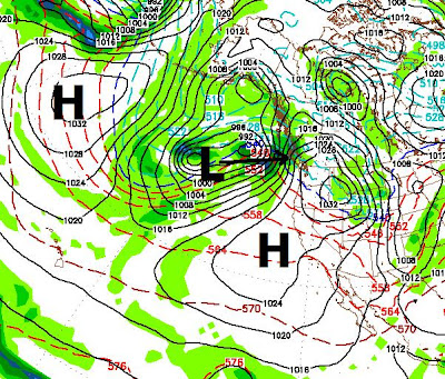
Our slow start to winter will continue for at least the next couple of weeks and probably until around mid December. Currently we have two large areas of High Pressure that are blocking any activity from getting anywhere near us. The only action we will see are sliders that come inland well north of us and slide down the through Washington and Oregon. Traditionally, these storms bring little if any precipitation. However, they do bring cold weather. Look for cooler temperatures for the next 3 or 4 days then a chance for a big warm up as the two high pressure systems become one and totally dominate our weather. I will keep an eye out for a change in this highly unusual pattern. Generally when a pattern like this breaks, it is a major event. I am guessing between the 15th and the end of December we could see some really stormy weather. I believe it was 4 years ago we had a similar slow start. Rose made snow from NW all the way down Kit to the bottom, that is how late winter was. Shortl

As Rose Remains Closed, Storm Falls Apart, High Pressure and Mild Weather to Move In

Image
Thanksgiving Travel Travel should not be affected by the weather for the entire weekend. The Sierra, mostly north, will see some light snow between noon and 4:00pm on Thanksgiving day. After that the roads should be clear and driving conditions should be excellent.   Bad News For Skiers and Riders A very slow start to winter is upon us. Mt. Rose was unable to open due to lack of snow and even snow making conditions. In addition, the decent sized storm that the models predicted a week ago has weakened considerably, will split and have nearly no impact whatsoever on the Sierra. To make matters worse for skiers and riders, a strong ridge of high pressure will move in and camp out, preventing any storms from moving into the area for the foreseeable future. As high pressure moves in it will block anything that does make it to our area from getting any sort of moisture tap. That means wind and no precipitation. Here is what we are looking at. Notice the 2nd area of high pressure. It wi

Frustrating Pattern Makes Forecasts Very Difficult

Image
  Yucksville We have been in a frustrating pattern that has baffled the weather models and made weather forecasters look like babbling idiots, including yours truly. Having said all that, I have not been far off. I also search for storms that are way out and try to will them in. Not exactly scientific but many skiers and riders like that about this column ... something to possibly look forward to. Storm 1 I am looking at a couple of storms. The first is knocking on the door. The models are generally in agreement. The storm, born in the Gulf of Ak, will travel down the west coast and cut inland somewhere between Central California and the Mexican border. However, GFS has this storm going right by us while EC has the storm coming down the coast more to the east and at least giving us a glancing blow. The first image is the GFS forecast, the 2nd is the EC forecast. This is for tonight and tomorrow. If the models are not in agreement 12-24 hours out ... then it is anybody's guess

Thanksgiving Day Party?

Image
Thanksgiving Day Blizzard I am tracking a decent storm that appears to be heading right for us on Thanksgiving Day. Obviously, your favorite Tahoe mountain will not be open by Thanksgiving, but if this thing holds together, it may be shortly thereafter. Amazingly, the two big long range models (GFS, EC) are in agreement about this one which is rare this far out. In addition the PNA is going negative for the last half of the month. Here is what GFS shows for Thanksgiving day: GFS and EC are showing between 2-4 inches of liquid precip with this storm which could translate into 18-40 inches of snow, if we are lucky: Notice the bulk of the precip staying to our north. However if a little more of that energy comes down to us we could turn this into a much bigger event. If you have plans to travel over the mountain passes, I would stay tuned to this blog in the coming days as I fine tune the timing of this storm. For now, it looks like the party gets rolling Thanksgiving morning.

2 Strong Waves Coming To Tahoe

I am currently enjoying 85 and sunny weather in Florida. I noticed that the weather has been summer like since I left town. The last time I left town was January. When I returned they were calling it June uary. Well, the good news is that I am coming home. The really good news is that we have 2 strong storms heading our way in the next 10 days. The first should be here on Friday and should last the weekend. The next arrives the following Wednesday and looks like a giant storm. When I am back in my office tomorrow, I will fine tune this forecast. Stay Tuned ...

Storm Late This Week Should Open Door For Possible Larger Storms

The larger storm for late this week that I have been tracking is going to slide down the California coast and make shore in Southern California next weekend. It will have little if any affect on our weather. That is the bad news. The good news is that it should open the door for a series of storms to follow in its path and hit the Tahoe area starting in about a week. The first of those storms should roll in mid day Sunday the 13th. EC has this as a decent storm for our area while GFS has it breaking up and only having a minor affect on the area. I will keep a close eye on this. The next storm should roll in late in the week, around the 18th or 19th. GFS has this as a decent storm, EC does not go out that far. I will be traveling, but should have time to post an update this weekend. Right now it looks about 50-50 to having the upper mountain open by Thanksgiving. Stay Tuned ...

Tricky Weather Pattern Emerging

Image
As the first storm in our 1-2-3 punch approaches, models are pretty consistent. The Sierra will pick up some snow but it will probably be amounts in the low range of my forecast earlier in the week. On the heels of this storm comes another for Sunday and Monday. Again, this storm looks as though it will develop a north to south trajectory and snow amounts again will fall into the lower range. To fine tune the forecast, I am now looking at about 1-2 feet of snow by Monday evening, likely in the lower range. The real tricky development comes Thursday of next week. The GFS model has a huge storm moving south and west right into our area. However the EC model has the storm moving south and getting trapped out at sea and having little to no effect for our area. Here is what GFS shows for early Thursday: Again, EC could not be more in disagreement with the GFS model shown above, here is what EC believes will happen to this storm: If GFS is correct, we could be looking at 3-5 inches o