Storm Update
As storms continue to move into Northern California, they slide south, not generating enough energy to make it over the Sierra. Our two best chances for snow come Sunday morning around 10:00 am and then very late on Sunday night through Monday morning.
I would say the storm tomorrow morning has the best trajectory to make it over the Sierra and have an impact on the Carson Range.
Just for comparison sake, the GFS does not see any wave coming late Sunday night into Monday, while the ECMWF model has the following for Monday at around 4:00am pst:
When we have this divergence in the models what usually happens is something in between. In that case look for light snow Sunday night through the morning on Monday.
All models have things drying out for at least the next 7 days and then we may be entering another storm cycle.
Stay Tuned ...
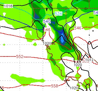
I would say the storm tomorrow morning has the best trajectory to make it over the Sierra and have an impact on the Carson Range.
Just for comparison sake, the GFS does not see any wave coming late Sunday night into Monday, while the ECMWF model has the following for Monday at around 4:00am pst:

When we have this divergence in the models what usually happens is something in between. In that case look for light snow Sunday night through the morning on Monday.
All models have things drying out for at least the next 7 days and then we may be entering another storm cycle.
Stay Tuned ...