Finally, Changes in the Forecast
With our ridge of high pressure getting pushed slightly west, that opened a very narrow door for what we call a slider storm. That is a storm that comes from the north and east and slides down the leeward side of the Sierra. Usually, these storms have very little moisture but they always bring cold air. In this case, we finally got some winds in the valley to change the air and clean it up.
That was the first sign that we are starting to see a pattern change. The next sign will come this Wednesday in the form of an actual storm. Not a big storm or even a moist storm, but a storm nonetheless. Although this storm will come from the north and west, it will be more north than west and will bring in even cooler air. Here is a look at the forecast for Wednesday @ noon:
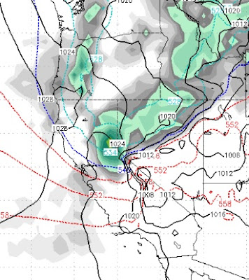
What we like to see is for these storms to tap into an active moisture plume from the south and west. As you can see this storm does not have much moisture to work with. Here are the forecast precip totals:
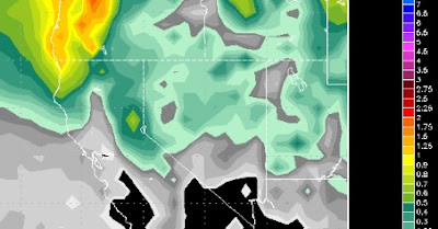
This will be all snow and snow will make it to the valley floor. For Slide Mountain I am thinking 8-16 inches of champagne powder. Disclaimer: These northern based storms (mini slider), are tough for the models to pinpoint, so cross your fingers.
Looking ahead, we have been talking about a change around Christmas and that still may be in the cards. The long range models are now starting to think January could usher in a major change, but let's not get too far ahead of ourselves.
Stay Tuned ...