First Good Storm of the Season Starts Monday
As mentioned in our last post, our first decent storm of the 2018 begins late Monday, should bring decent precip for most of Tuesday and clear out on Wednesday. High pressure builds in behind the storm, but we feel as though that will be short lived and our next series of storms should come about mid month.
These past two storms were exactly as advertised. The next storm will come in warm and eventually snow levels will drop. Again, the big winner on these sub-tropical storms is Mt. Rose with it's high base. Here is a look at the forecast for very early Tuesday morning when the largest wave of precipitation hits the area:
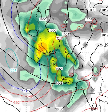
At the risk of sounding like a broken record, our forecast has pretty much remained the same for the last five days.
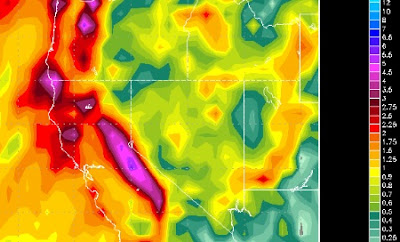
Here is the precip outlook. This storm could come in as high as 8,500 feet but will quickly fall below 8,000 feet. We look for Mt. Rose to pick up between 18-36 inches by Wednesday morning:
Not bad for this year, but nothing like what we were seeing and forecasting last year. I sent a friend an email around this time last year and told him we could be looking at 20+ feet of snow in the next 10 days, to which he replied, "NOAA says only 6 inches", to which I replied, "NOAA is wrong, we have never seen this type moisture and it is going to slam us head on." That 10 day period Mt. Rose picked up somewhere between 15-20 feet of snow causing massive avalanches down the chutes which buried the slide bowl highway. Fond memories! Click the following link to take a ride down memory lane:
Last Year's Post
As this storm moves out, look for high pressure to build in. But that will be short lived as we see another change on tap for around Sunday the 14th as the southern born storms move the ridge out to sea and bring in a trough to the jet right to our area.
Stay Tuned ...
These past two storms were exactly as advertised. The next storm will come in warm and eventually snow levels will drop. Again, the big winner on these sub-tropical storms is Mt. Rose with it's high base. Here is a look at the forecast for very early Tuesday morning when the largest wave of precipitation hits the area:

At the risk of sounding like a broken record, our forecast has pretty much remained the same for the last five days.
Here is the precip outlook. This storm could come in as high as 8,500 feet but will quickly fall below 8,000 feet. We look for Mt. Rose to pick up between 18-36 inches by Wednesday morning:

Not bad for this year, but nothing like what we were seeing and forecasting last year. I sent a friend an email around this time last year and told him we could be looking at 20+ feet of snow in the next 10 days, to which he replied, "NOAA says only 6 inches", to which I replied, "NOAA is wrong, we have never seen this type moisture and it is going to slam us head on." That 10 day period Mt. Rose picked up somewhere between 15-20 feet of snow causing massive avalanches down the chutes which buried the slide bowl highway. Fond memories! Click the following link to take a ride down memory lane:
Last Year's Post
As this storm moves out, look for high pressure to build in. But that will be short lived as we see another change on tap for around Sunday the 14th as the southern born storms move the ridge out to sea and bring in a trough to the jet right to our area.
Stay Tuned ...