Storm Update
The winter storm that we have been talking about for the last two weeks is now upon us. This is an update on the timing of the storm:
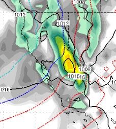
The storm will come in essentially two waves. The first wave is just now starting up. It will come in warm with the counter clockwise rotation pulling up moisture from the sub-tropics. This is the bigger of the two waves and will last until late tomorrow night with near constant, heavy snow. The elevation will be high to start, but should quickly drop. I believe Mt. Rose will get all snow, but would not be surprised to see snow elevations at the 8,000 foot level or even a little higher to begin with. The heaviest precip will be from 4:00 this afternoon until late morning tomorrow. Here is a look at the peak of the storm which should be around midnight tonight:
There will be a break in the snow that should start very late tomorrow night and last through most of the day on Thursday before the next wave comes in.
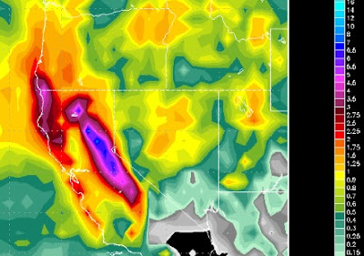
The 2nd and final wave comes in late Thursday night. It will not be as strong as the first wave, but will still pack a punch and should stick around until Saturday morning. The duration of the 2nd wave is slightly longer so I expect about the same amount of precip. However, I expect more snow from the 2nd wave as the cold front will have already moved through. Here is a look at the heaviest precip of the 2nd wave which should be Friday afternoon:

Notice the blue line; that is the cold front which has already moved through. Folks, most of this storm should see snow levels below lake level so again we are looking at a major snow event for all Tahoe resorts and all elevations.
Total expected precip for the storm should be between 3 and 6 feet. The western crest of the Sierra could see higher amounts, up to 12 feet, and I expect the Carson Range and Mt. Rose to be in the 4-5 foot range.
We are tracking an even bigger storm for the following week. Right now the EC model is showing the storm arriving next Tuesday and could stick around for quite some time, perhaps as long as a week, so the storm door remains wide open for now.
With the March Miracle in full swing, we have now adjusted our 2017/2018 Sierra Snowfall to average from 70% of average. These storms are really increasing the snow pack late in the year and are very beneficial for all of the west, especially California. I love it when Ma Nature reminds the nay sayers (NWS, NOAA) that she is in charge and not them!
Stay Tuned ...
The storm will come in essentially two waves. The first wave is just now starting up. It will come in warm with the counter clockwise rotation pulling up moisture from the sub-tropics. This is the bigger of the two waves and will last until late tomorrow night with near constant, heavy snow. The elevation will be high to start, but should quickly drop. I believe Mt. Rose will get all snow, but would not be surprised to see snow elevations at the 8,000 foot level or even a little higher to begin with. The heaviest precip will be from 4:00 this afternoon until late morning tomorrow. Here is a look at the peak of the storm which should be around midnight tonight:

There will be a break in the snow that should start very late tomorrow night and last through most of the day on Thursday before the next wave comes in.
The 2nd and final wave comes in late Thursday night. It will not be as strong as the first wave, but will still pack a punch and should stick around until Saturday morning. The duration of the 2nd wave is slightly longer so I expect about the same amount of precip. However, I expect more snow from the 2nd wave as the cold front will have already moved through. Here is a look at the heaviest precip of the 2nd wave which should be Friday afternoon:

Notice the blue line; that is the cold front which has already moved through. Folks, most of this storm should see snow levels below lake level so again we are looking at a major snow event for all Tahoe resorts and all elevations.
Total expected precip for the storm should be between 3 and 6 feet. The western crest of the Sierra could see higher amounts, up to 12 feet, and I expect the Carson Range and Mt. Rose to be in the 4-5 foot range.

We are tracking an even bigger storm for the following week. Right now the EC model is showing the storm arriving next Tuesday and could stick around for quite some time, perhaps as long as a week, so the storm door remains wide open for now.
With the March Miracle in full swing, we have now adjusted our 2017/2018 Sierra Snowfall to average from 70% of average. These storms are really increasing the snow pack late in the year and are very beneficial for all of the west, especially California. I love it when Ma Nature reminds the nay sayers (NWS, NOAA) that she is in charge and not them!
Stay Tuned ...