Posts

A Tale of Two High Pressure Systems

Image
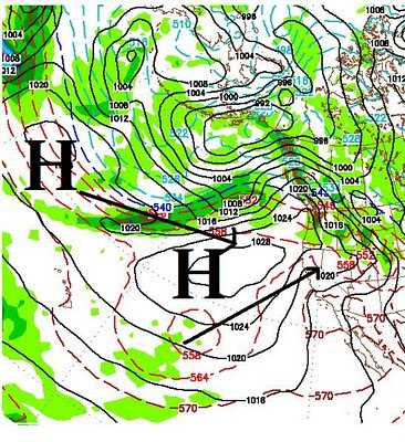
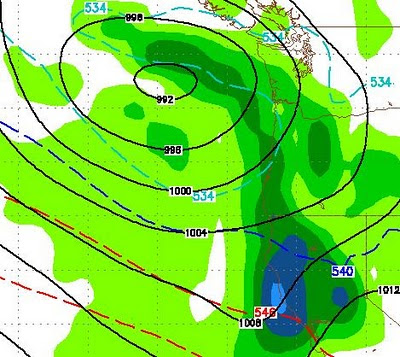
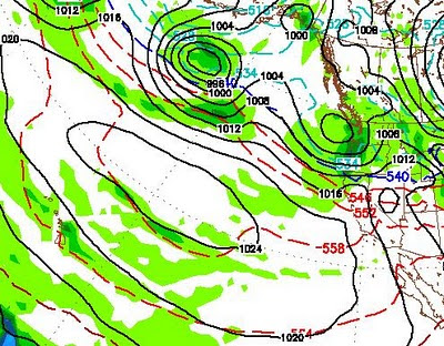
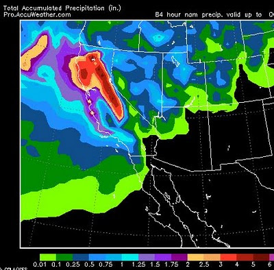
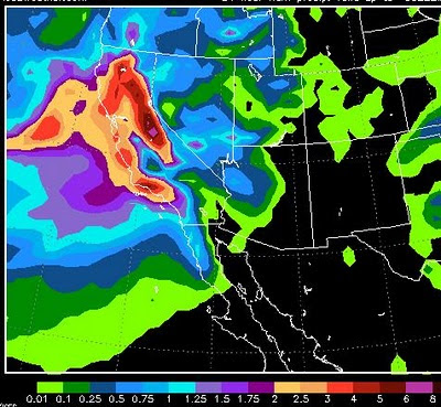
As I talked about in my last two posts, high pressure is going to dominate our weather into the foreseeable future. Take a look at the weather map for Wednesday night: High pressure off the California coast will be joined by another high pressure system. The two systems, which will form one bigger system, will actually shift slightly north and block any type of weather activity from Tahoe. In addition, warm and very mild air will accompany the blocking systems, pushing temps in the leeward valleys into the 70's by Thursday. As the storms come ashore well north of our area, we will get some wrap around affect, but that will be mostly wind and slightly cooler temps. Return To Stormy Pattern? That is the bad news, the good news is that this pattern should break down around the middle of April. Right now it looks like this could usher in another very stormy pattern. Currently the models are not picking up on this, however the NOAA PNA takes a very abrupt negative shift toward th

Last Storm In Series Strengthens; Poised to Slam Tahoe Tomorrow

Image
The last storm for a while has strengthened and should slam into Tahoe very early tomorrow morning. Here is a look at the GFS forecast for 5am tomorrow morning: Although this storm is the weakest of the bunch, look for 1-2 feet above 7,000 by tomorrow night. Ridge City follows with mild temps and plenty of sunshine. Squaw Valley has reported 220 inches of snow (19 feet) in the month of March and 55 feet for the season. I guess the next time people hear of La Nina, they will think snow. Stay Tuned ...

Record Snows End Abruptly On Sunday

Image
In my last post I hinted that we may be moving out of the record breaking winter storm pattern that we have seen almost non-stop for a month. It now appears that an extremely strong ridge of high pressure is moving to our south and west. This ridge will dominate our weather, starting Sunday, for at least 10 days. It will usher in much warmer temperatures. Golf courses all over the valley should be open by Tuesday. Here is a look, notice the huge ridge off the coast of California, that ridge should keep the storms well north of us: GFS has this ridge entrenched for at least 10 days with little or no movement. Bottom line, enjoy the Pow this weekend as the storm cycle appears to be coming to an abrupt halt. Stay Tuned ...

Get Ready For a One-Two Punch

Image
Two Storms, Back to Back In my last post, I laid out storms and timing. I am happy to report that not much has changed. We have a smaller storm just now coming ashore in Northern California. On its heels, we have a much larger storm. The two storms are going to pack a strong one-two punch. Here is the 84 hour precip chart: These two storms should drop around 3-5 inches of liquid precip in the Sierra. I am guessing very similar amounts in the Carson range. That should translate to about 3-6 feet of snow by Sunday. The heaviest band appears to be set for Thursday night and Friday, here is the GFS forecast for Thursday afternoon as the big storm approaches: As of now it looks like the best days to hit the POW are still Thursday and Saturday. However these storms and a third storm are coming in so close, it could snow right through this weekend. How Long Can This Last? My friends at Unofficial Mt. Rose (See link on right of post) have labeled this the March Miracle. Quite appro

Correction

My apologies, but the 3rd and 4th image from the last post were the same. I have placed the correct 4th image on the post. The winds are holding off for now and the storm is slamming us. The lifts are open, get up the mountain!

Storm Timing and Snow Amounts Through Next Weekend

Image
I am going to publish vital stats for the next 4 storms. These forecasts include the Sierra and Carson Range Sunday/Monday/Tuesday Start - Sunday Morning Peak : Very Early Monday Morning Best Skiing/Riding: Monday Amount: 2-4 feet - South getting more than north Briefly: Storm moves in late Saturday night, initially hitting north of Tahoe. Picks up steam on Sunday and moves south early Monday morning. Picture (Early Monday Morning): Wednesday/Thursday 3/23-3/24 Start - Wednesday Afternoon Peak : Thursday morning Best Skiing/Riding: Thursday Amount: 6-18 inches Briefly: Weakest storm in the bunch, comes straight from the west. Gets pushed out by bigger storm on Friday. Picture (Wednesday Afternoon): Thursday/Friday/Saturday 3/24-3/26 Start - Thursday Night Peak : Friday afternoon Best Skiing/Riding: Saturday Amount: 2-5 feet Briefly: Strong storm coming in from north, long wave pummels Tahoe for 3 days. Friday. Picture (Friday Night): Sunday/Monday 3/27-3/

It's Going To Snow For A Week

Image
The next storm in our series is knocking at the door and should produce 12-30 inches of snow for Rose. I would not be surprised if we were at the upper end of that. Let's take a look at the 84 hour moisture chart: This chart represents liquid precip from two storms that are going to slam our area and most of California. Incidentally this does include the leeward valleys of the Sierra and I would not be surprised if NWS issues a Winter Storm Warning for Reno and Carson. If you live in the foothills, expect heavy snow, perhaps as much as a foot by Tuesday. Now back to the above chart. Mammoth and the Central Sierra are going to get nearly 8-10 inches of liquid precip from these next two storms. That is over 100 inches of snow. Kirkwood is clearly in the 6-8 inch range, while the Tahoe Crest is in the 4-6 inch range. The Western Tahoe Crest should pick up 6-10 feet of snow by Tuesday morning. The chart above has slide mountain in the 2-3 inch range (liquid precip). However, I j