Posts

Not Much In Short Term, Long Term Starting to Look Good

Image
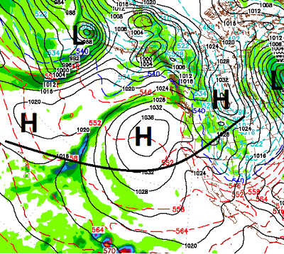
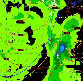
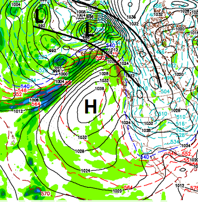
Short Term This little storm that has been producing light snow showers has certainly shown more gumption than I thought it had. Having said that, it will only leave a few inches of snow behind in the Sierra and only at the upper elevations. In my last post I talked about a cold front heading our way for Sunday. We are still on track for that storm and I am hoping that we can squeeze 4-8 inches out of it by Monday night. Then high pressure moves in. Here is a look at Wednesday the 30th of January. As you can clearly see, high pressure will be dominating the entire west coast. The storm for Sunday will usher in some much cooler air, but that cooler air will be short lived. For you hockey players that are looking for frozen lakes, the short term does not look great. You may be able to squeeze in some ice time Monday through Thursday of next week ... but that may be pushing it. Long Term Things are definitively changing. In my last post I talked about larger storms that could c

Conditions Change In a Week

Image
Take this with a grain of salt; the weather pattern will change in about a week from today (1/27). At that time conditions will ripen for a series of storms to come into our area. Here is a look at the first storm, which right now appears to be the best chance for some precipitation. The two images reflect about 12 hours of precip that should be coming our way next weekend. The next chart shows why I am confident this storm will make it down to our area. You can see quite clearly that the storm door will open. This too is a chart for the 27th: So conditions will be favorable next weekend. However I want to qualify this. Right now I do not see a major storm cycle. In fact, I do not see a major storm cycle at any time in the next 2-3 weeks, at least. The storms are not very big and our ridge of high pressure does appear to be in a favorable blocking pattern for the the western 2/3 of the USA for the 2-3 weeks, with the exception of this Sunday. Another qualifier; It does

Cool Dry Period Will Continue

Image
We have been talking about a dry period now for the last couple of weeks. That is what we are in and it will continue for at least two weeks unless something changes that cannot be foreseen at this time by the weather models. You may remember the beginning of last winter; A powerful ridge of high pressure set up right off the west coast of the US. Well, that is exactly what we have and what we will have into the foreseeable future. Here is a look at the conditions. Notice the giant ridge of High pressure off the coast. That will block any storms from coming into our area. At the same time, our weather is straight out of the north. This pattern will continue until that ridge actually moves. As air revolves clockwise around the ridge, we will continue to get pummeled with cooler than normal temps and deep valley inversions as winds will also be very light. Things will warm up slightly toward the middle of next week. Then the following week we are seeing indications of the ridge br

Cold, Fast Moving Storm For Wednesday Night and Thursday

Image
Happy New Year. As I mentioned in my last post, things were going to dry out and they have. I very strong ridge of high pressure has camped out over Tahoe and brought extreme inversions to the area with very poor air quality in the leeward valley's of the Carson Range. Short Term That should finally mix out as a very cold Low Pressure system is going to drop into our area and bring with it very strong winds, warm air ahead of the front and very cold air behind the front. As the valley's finally mix out of the cold and dirty air tomorrow afternoon, high temps will reach the 50's and possibly 60's as this front pulls up warm air from the south. That will be short lived. Unfortunately this storm is somewhat moisture starved. As the cold front approaches snow levels will reach the valley floors and I expect 6-18 inches in the Sierra above 7,000 feet. Lesser amounts at Lake Level. We are looking at less than an inch of liquid precipitation with few exceptions throughout

Final Storm in Series Starts Tomorrow, Then We Dry Out

Image
First of all Happy Holidays to all! Thank you for the very nice comments on the mountain! Now back to business; A well advertised storm will be moving in tomorrow night. The squeeze is on again as blocking ridges of high pressure will force that storm down through our area. Unlike the last storm, the exit door is wide open so we will not get 4 days of heavy snowfall. Here is a look at how things will shape up tomorrow. I actually talked about this one in the beginning of the month. In my last post I mentioned that this storm will have a more profound affect south of Lake Tahoe. That is still the case. However, I do expect a foot of snow for the Northern Tahoe Sierra and Carson range by Wednesday night. I do not see any major precipitation events after this next storm for 2-3 weeks. We are going to dry out. We may have a weak storm come into the area New Years day, but the models are picking up on a long dry period. That is the bad news, the good news is that around the 17th

It Will Keep Snowing

Image
Another strong wave of snow is coming into the Tahoe area with significant snow for the Sierra and Tahoe Basin set for this afternoon through X-Mas Eve morning. I talked about this wave a week ago and am still impressed. Here is a look at late tonight: This storm will have a greater impact in South Lake Tahoe area but will deliver 2-4 feet of additional accumulation for all of the Sierra around Tahoe. I believe Slide Mountain will pick up an addition 18-30 inches in the Carson Range. This storm will continue until tomorrow afternoon. There will be a quiet period tomorrow night. For those of you looking for cold weather, it will be very cold Christmas Eve night. The next storm comes in late on the 25th and will last through the 26th. This storm will again have a more profound impact in the South Lake Tahoe area. Here is a look very late on the 25th as this storm approaches: I expect another 1-3 feet for the Sierra with the heavier amounts south. The Carson range should get

Storm Update

Forecast from prior posts are right on. The next big moisture plume should arrive late morning early afternoon. Then another tomorrow morning. Snow amounts will be in the 4-8 feet range. Much of it depends on where you are. I am still looking at 4-5 feet for Slide Mountain with very good coverage down to the Washoe Valley. The valley forecast from last post is close, but it appears I may have underestimated the amount of snow. I am now looking for 1-3 feet for the foothills above 5,500 feet and up 6-12 inches for the valley floors. In addition, the storm for the 27th is still looking good with another 1-2 feet for the Tahoe resorts. It appears the heaviest snow may be the south side of the lake down to Mammoth. I will talk more about this storm tomorrow. Merry X-Mas!