Posts

Is it too late for a change in the Weather Pattern?

Image
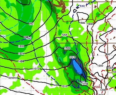
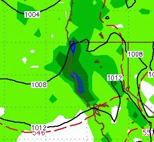
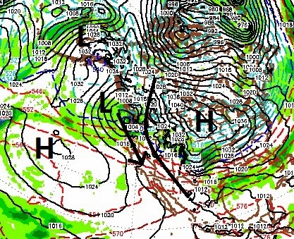
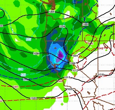
Both EC and GFS weather models are suggesting a major spring storm could hit the Tahoe area in a little more than a week. Both models are suggesting that our first decent storm cycle in over a month is on the way for the last week of skiing at most of the Tahoe resorts. This is not, by any means, unprecedented. In fact, this has been one of the worst springs in recent memory for storms. Large April storms are the rule not the exception. Most years are good for at least one and if you believe the weather models, a storm could be on the way. Here is a look at the EC model forecast for the 7th of April: The GFS model is showing a remarkably similar forecast. Here is a look at the precip potential for this storm: Interestingly enough, the GFS has a series of storms coming in starting early next weekend and getting progressively stronger. These models have been teasing us all year with storms that do not live up to their potential. Under achieving storms, so beware. It is

Possible Snow For Early Monday

Image
A weak storm will gain some strength, come down from the north and should leave the Tahoe area with some accumulating snow. However, there will be a rain shadow at the crest which will limit accumulation in the Carson range. Here is a look at the forecast for very early Monday morning: Here is a look at the precip forecast. Most of the precip stays west of the Sierra: I am not seeing any weather anomalies headed our and we should move to dry pattern starting Tuesday afternoon. The Western Crest of the Sierra could pick up 6-12 inches by Tuesday afternoon while the Carson range will be limited to 1-4 inches. Stay Tuned ...

Weak Storms Continue

If you read my last post, you were disappointed with the storm that passed through our area yesterday. The storms are just too weak to cause much havoc, which is not totally unusual for this time of year. However, I know I am beating a dead horse, we are so due that I have been fully expecting something extraordinary. Well folks, it does not look like it is in the cards. There are a few very weak disturbances that will pass through in the next 10 days, but nothing much. Before we get too far ahead of ourselves, the weather has been very difficult to forecast these last few years. Oftentimes these weak storms can pick up some moisture or get blocked out by something thousands of miles away, and then everything can change. So let's hope that happens. If it does, you will know ahead of time. Stay Tuned ...

Storm Cycle Could Start Up Again Around the 11th of March

Image
I am seeing indications that a new storm cycle could crank up again around the 11th of March. Both the EC and GFS models are forecasting a decent storm heading our way in about a week. That could possibly usher in about 5-7 days of stormy weather. Here is the EC forecast for the 11th of March: I know this does not look that impressive, but the models have been going back and forth on just how large a series of storms will be, starting around the 12th. The GFS has been hinting a a much larger storm for our area around the 15th. Unfortunately, the models have not been able to stick with a forecast on a consistent basis. I thought I would put this out there. I will continue to track this possible event and report accordingly. Stay Tuned ...

Models Temper Down Storms

We have a fast moving storm approaching for Friday. However, that storm will make land up in Oregon and come down with a really crappy trajectory ... if you want snow that is. With it, more cool air is on the way. The pattern will probably hold for another week or so before another chance at storms comes in. Sorry folks, but that is all I have. The 30 day is still showing some promise, but these storms appear to be fizzling out again. I am hoping for a major change in a couple of weeks or so, but have nothing I am willing to show. About the only good news I have, is that we will stay on the cool side for the next 7-10 days starting on Friday as we get into that north flow. Good news if you are trying to manage a hockey pond! I am leaving town for a few days, hopefully something will start to spin up around the time I get back. If so, I will let you know. Stay Tuned ...

Return to Stormy Weather By Months End

Image
The models all appear to be aligning for a stormy end of February and a stormy beginning of March. The latest to hop on the bandwagon is the European model. Our ridge of high pressure is still firmly in place. However, an even larger ridge of high pressure will setup over the Northern Plains/Great Lakes and act as a pretty good blocking force. This will send Pacific storms down the coast and into our area and even further south. Here is a look at what we can expect around around the 27th of February As the a High Pressure ridge sets up in the North Central US, storms will be forced down the coast. With any luck, this pattern will hold well into March, however it is too early to say. The models are hinting at a pretty good storm on the last day of February. Here is a look at the EC weather model for the 28th: Currently, the GFS model has the initial wave being weaker, but follows this storm with several larger storms. Here is a look at March 2nd: GFS has a

Pattern Change by Months End?

Image
I understand that I am beating the proverbial dead horse, but we are due for something big. Over the last 3+ years we have seen below average, and in most cases, way below average precip here in Tahoe. It is even worse south of here. Averages exist for a reason, the world does not change overnight so I still fully expect a major pattern change to usher in a very wet spring. Having said that, I can base this on no scientific data, historical data, weather trends, oscillations or anything else, at least not consistently. By no means am I complaining about the near perfect weather that we have seen around Tahoe for quite some time. But, enough is enough, we live in the snow belt and it is about time we got some snow. The GFS weather model, for the past couple of days has been hinting about a pattern change. That change could come as early as the 26th or as late as the first of March. Interestingly enough, today the EC weather model joined the party. The GFS is more aggressive, but EC