Posts

Stormy Weather Pattern to Return

Image
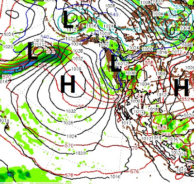
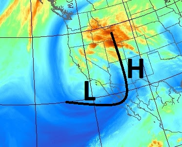
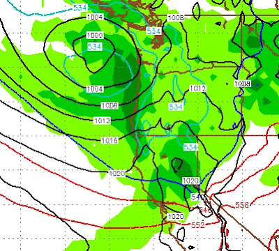
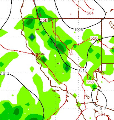
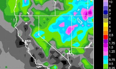
A low pressure system will squeeze our persistent ridge of high pressure to the west and effect our weather for at least the next week and probably longer. The ridge of high pressure which can dominate our weather will be moved out of the picture allowing storms to come into our area from both the East and the West. The following two images show the current conditions and conditions in about 4 days. Notice the high pressure ridge getting moved to the west: This will usher in a change to our weather that will last into the foreseeable future. Snow levels for these storms will vary from 8,000 to 10,000 feet. The blocking ridge of high pressure will allow moisture to be pulled into our area from the Gulf of Mexico ... again. Just goes to show, Mother Nature will do as she damn well pleases. Stay Tuned ...

Wet Weather to Continue Through Weekend

Image
If you read our last post, then you were warned. Heavy, consistent rain has been falling for a couple of days now. This will continue through the weekend to some degree. Probably not as heavy or as consistent as what we have seen of the last 36 hours. High pressure over New Mexico and Arizona is blocking a Low Pressure system located just off the Southern California coast. This is causing ample moisture to work its way back east into our area. Ironically, as this moisture hits the Carson range, it is somewhat shadowed. Very little of it is making it over the Sierra and into the California valleys where it is needed most. Northern Nevada had broken out of the drought a long time ago. I believe that the same holds true for Northern California but I will let the politicians, who know nothing,  argue about that in the context of man-made Global Warming. Here is a look at our current conditions. Notice the Low Pressure system sending moisture north and into our area and the Northern Roc

Very Wet Week Ahead

The Tahoe area and Leeward Valleys of Northern Nevada are in for a very rainy couple of weeks, at least. Several factors are involved, including off short troughs in the Pacific NW and inland troughs both southeast and northeast of us. Add a blocking ridge and we are going to see moisture coming from all directions. Our top researcher, Paul H, had this to say about what to expect long term: The wet pattern appears to continue till at least May 11 and is now indeed looking to be an interesting end to this interesting Super El Nino. I want to say I see a break in the Sierras from this wet cool weather but I'm not and it must be similar to what the dark ages were like in Europe- the summer solstice with frost and sleat. To be honest I believe the "sleep of the sun" (solar minimum) is playing a role in all this from the severe weird drought to extremely warm oceans to now this bizarre cool wet pattern I'm seeing continue into June. The Law of Thermodynamics and heat d

Large, Cold Storm will Usher in a Return to Winter

Image
There is a large storm that will hit the Tahoe area and bring back memories of December for at least 36 hours. Looking ahead, we are going to be in a very stormy pattern with below average temperatures through next week ... at least. First things first, starting Thursday night a large storm (for this time of year) will begin to approach Tahoe and bring with it very gusty winds. The brunt of the storm will hit late Friday afternoon. Here is the forecast for around 4:00 no Friday: As with many storms this time of year, this storm will work its way south down the Sierra and bring at least double the precip to the Sierra compared with the Carson Range. But fear not, a series of short wave sliders will continue to bring in waves of cool air. These storms tend to work their way down the Carson Range and bring more precip to the Eastern Sierra and Carson Range. They also bring plenty of cold air as our dominant weather pattern will be from the north. The storm for Friday/Saturday w

Strong Cold Front for Wednesday, Thursday. Much Warmer this Weekend

Image
A strong moisture starved low pressure system will fall out of the north and put the chill in our weather starting late tomorrow. This storm packs more cold air than anything else. It will bring little if any precip to the Carson Range (1-3 inches), more is possible for the Western Crest (3-6 inches). From a wind standpoint, this storm is relatively tame. I suspect the lifts at Rose will spin most of the day tomorrow and all day on Thursday. Although the temps will be significantly colder. Here is a look as the storm rapidly approaches out of the north very late tomorrow night: This storm will dive south after making landfall and break up for the most part. Most of the strong winds will be late Wednesday and very early on Thursday. Winds will die most of the day on Thursday but will be out of the north and cold! High pressure takes over starting Friday and by Sunday we will be well above average, perhaps mid-70's for the leeward valleys. This high pressure system will stic

Don't Count El Nino Out Yet as Winter is Coming Back

Image
Winter is going to make a comeback over the next 7-12 days at least. A small storm is coming in from the south and will actually deliver some much needed rainfall for Southern California. Although, I do not see a major rain event, they will take what they can get. That southern storm will work its way north into the Tahoe area and produce rain and upper elevation snow. Then, a larger storm will drop down out of the north and remind you of January around the middle of next week. This storm will bring beneficial rains to Northern California and snow to the Western Crest of the Sierra. Interestingly enough, the models are not in agreement here. The GFS is more bullish on both storms producing precip for California. The EC is has lighter amounts and later timing, but believes the Carson Range and the leeward valleys will join in on the party. I usually side with the EC as it has been the more reliable model. Let's start with the GFS for late on Friday: This storm is centered

Cold Slider Comes Tonight

Image
The weather models are moving our slider slightly further west on its trajectory to Tahoe. That could bode well for more moisture for the storm to work with. I was not bullish on this storm yesterday. Today I am a little more optimistic. The storm comes in tonight and will stick around through Tuesday. The impact of this storm will be felt on the eastern side of the Sierra Crest and the Carson Range. Perhaps the biggest impact is the cold front that is coming with this storm. Temperatures will be much colder through most of the week. Nobody is trying to predict snowfall amounts. I am going with 6-18 inches for the Carson Range by Tuesday night. Slightly more for the eastern side of the Sierra Crest. Here is a look at the Precip forecast by the EC weather model: Dry weather follows through the week. Stay Tuned ...