Posts

As Ridge Breaks Down, We Could (finally) See a Decent Storm

Image
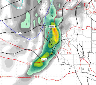
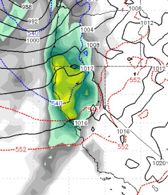
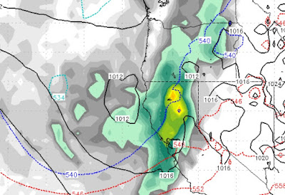
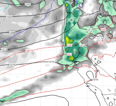
Our persistent high pressure ridge has been dominating our weather for most of the season, which is not totally unusual. However, the weakness of the storms to penetrate the ridge has been somewhat surprising. We are starting to see at least a temporary break-down of the ridge as it slides south which should open the storm door for 4 or 5 day event starting next weekend. Here is our current condition: Notice how this ridge is blocking any storms from getting to our area and blocking any tropical moisture taps for storms that do reach our area.  Our weather is sliding down the eastern side of the ridge is also bringing us much colder air. Now take a look at what develops for next weekend: As the ridge slides south, the jet dips down and through our area. There are then several storms that should slam right into us. Our tropical moisture tap is still being blocked, but we are tapping into some moisture which should increase the amount of precip these storms deliver. We s

Much Advertised Storm To Move in Today

A weak to moderate storm will move into Tahoe today bringing rain and snow to the area. Following the storm will be a strong cold front that will drop temperatures significantly. We expect around 12-18 inches for snow through Christmas day for the Carson Range. More for the western side of the lake. Behind the precip will be very cold air and a series of short wave sliders will reinforce that cold air through the end of the year bringing additional light snow, with another storm on tap for New Years Eve. Snow levels for this event will drop down to 5,000 feet with the potential for up to 6 inches of snow for the leeward foothills. This will certainly help the resorts around Tahoe but is will not be the answer to our snow prayers, nor does it look like next week's storm will bring a strong Sierra event. We are still looking out for that and are confident it will come. We apologize for our absence but the day job got in the way. Merry Christmas, Happy New Year to all!

One Storm then Dry Through Christmas

Image
We need this next storm to produce. In a year where the storms have under performed, we have what could be an okay storm that could bring a foot of snow. That storm comes in very late on Sunday and should last through early Monday morning. The GFS has this storm moving through much faster than the EC, but we are confident this one should leave behind some snow. Here is a look at late Sunday night: After this storm, the models are saying dry weather for at least the next week as our ridge moves back into position. There will be a few glancing blows, but overall we see no major snow events for the Sierra. That is the bad news, the good news is, the ridge should break down shortly after Christmas which will give us a chance for additional storms to move through the area. Conditions have just not been favorable for a major snow event, unfortunately. We will keep an eye way out and report accordingly. Stay Tuned ...

Two Storms Headed Our Way

Image
The weather pattern remains active, despite the very disappointing performance of this last storm. We are tracking two storms; one for late Friday and another for late Sunday. Here is the forecast for the Friday storm, the weaker of the two: Here is the forecast for the Sunday night storm: Both of these system are fast moving so we will not see any epic dumps out of this. However, in a best case scenario Mt. Rose could pick up a couple of feet by this time next week with the bulk of the snow coming late next weekend. Valley Inversions The leeward valley's will continue this awful inversion which is trapping the fog and moisture until about Wednesday. A very weak and dry system should cause significant mixing and kick that crap out of here which should allow the sun to finally shine through and warm us into the upper 40's or low 50's, especially Friday and over the weekend as these storms approach. The next two systems will remove any remnants of the fog and h

A Couple of Near Misses, Then a Chance For Something Better

Image
The weather pattern remains active with several storms coming at us from the west. Currently, the models have these storms with just a glancing blow on Wednesday (12/5) and Saturday (12/8). However, both the GFS and EC models are showing the possibility of a moderate storm coming into the Tahoe area around the 9th  of December. We talked about this in our last post. First here is the ECWMF forecast for early on the 10th of December: Here is the GFS forecast for just about the same time: We don't see this as a very strong storm, but a lot can change between now and then. There is the possibility of another storm around the 15th of December, then we may be looking at our ridge moving back off the coast for a week or so. As of now we are looking at a dry period between the 15th of December and the 23rd. The storms return around Christmas and should be much stronger. Stay Tuned ...

Storms Update; Epic December in Store?

Image
After a very disappointing performance by the snow gods last week, we are on the eve of several storms for this week. The first of those storms arrives tomorrow (11/27) late afternoon: Although the models have this storm weakening as it makes land, it does pick up some sub-tropical moisture, which is revealing for the next storm. This first storm will hit in several waves, with snow levels starting around 7,500-8,000 feet and falling to around 6,000 feet as the storm passes through. The second storm has the most potential and the NWS is calling for a major snow event above 7,000 feet. Generally when they do this, it happens, they are the experts after all. The 2nd, in our series of storms, arrives late Wednesday night from the Southwest. This storm will bring down some cooler air and I am confident this one will be all snow for Mt. Rose. The other ski areas may start with rain at their lowest elevations, but this storm will fall well below lake level and should be very benef

Storm Door to Remain Wide Open

Image
Another storm is poised to hit the Tahoe Area today and should get cranking this afternoon. This storm will pull sub-tropical moisture from the south, which will raise snow levels to 8,000 feet or higher. After a short break, the storms return on Tuesday and should last through Thursday and even into Friday. Here is a look at the peak of next week's storms late Wednesday night (11/28): Snow levels next week will probably be 7,000 feet or lower, but we will get a better indication in a few days. After another short break, a large storm moves into the Pacific NW and will potentially bring a major weather event to Tahoe. Right now the models have the bulk of the energy staying north, but if that storm shifts just a bit south, we could be talking about a real Sierra Blizzard event. Here is what things may look like Saturday December 1st. Regardless, this storm will bring additional heavy snow to the region: So the total precip outlook for the next week or so looks lik