Posts

Very Dry Start to Winter

Image
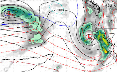
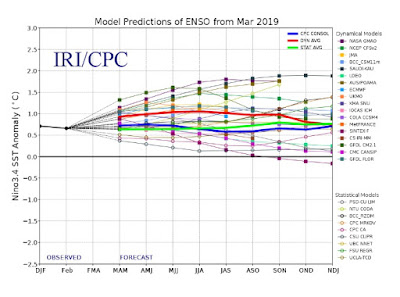
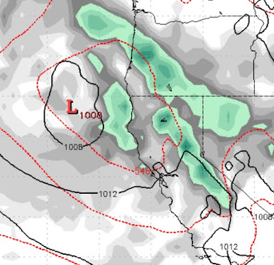
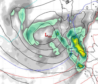
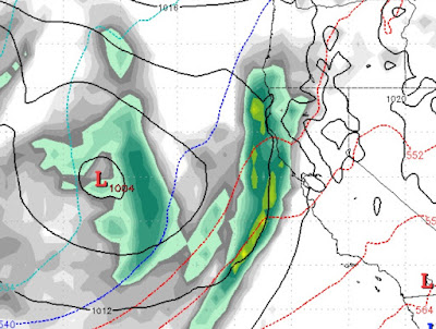
Assuming that Tahoe winters can begin in mid-October and sometime last through May, this looks to be a very dry start with widely varying temperature swings. It is very difficult to forecast weather for 30 days, but I ran the EC Monthly just this morning and here is what it is saying: Basically, it is forecasting that we are are looking at less than 1 inch of liquid precip between now and November 20th. Most models are calling for a very dry start to winter which is not surprising if you read our Winter Outlook column. Having said all of that, Mother Nature is in charge and not the weather models. I expect this to change somewhat, but we still expect cooler and drier than average precip and temps this winter. A strong and dry cold front will be coming down from Alaska and will drop our temperatures about 40 degrees on Sunday/Monday. Temps will slowly recover in the following week. We expect this pattern to continue. Stay Tuned ...

Winter 2019-2020 Outlook

Long time no post. I hope everybody had an enjoyable summer! Despite our very snowy beginning to 2019, the precip tapered off in the spring and especially in the summer. The tinder was not quite as plentiful and we also were very lucky to have a reduced fire season. We have several very cold storms headed our way over the next several days, which will produce some precip for Northern California, that should continue to dampen the fires that are currently burning. We will also see off and on snow ranging from 6,000-8,000 feet in both the Sierra and Carson Ranges. However, temperatures will eventually warm up and most of that snow will melt. If anything looks serious, we will post, but for now, fairly typical September weather. 2019/2010 Winter Outlook With El Nino all but a forgotten memory, we have moved into a neutral ENSO. We have seen how El Nino and his sister La Nina can have a very profound effect on our weather. However, with El Nino gone we will need some other anomali

Winter Starts Again Thursday

Image
Do not be fooled by this nice stretch of weather; El Nino is still out there which means the potential for winter storms is still very strong. One such winter storm will show up very early on Thursday morning: This is a very strong storm for this time of year and will usher in a pattern change that will last a week and put our nice stretch of weather far in the rear view mirror. As you can see by the map above, a series of storms is headed our way with the final storm in the series due about a week from today. This pattern change will usher in much cooler and much more unstable air. That means very windy over the course of the next week with snow levels at times approaching 5,500 feet! What is amazing about this pattern change, occurring in the middle of May, is the amount of precip that is coming with it. Here is the precip forecast for the next week. Folks, we could see up to 5 feet of snow in the Western Crest of the High Sierra I believe Slide Mountain will pick

El Nino Through 2019; Unofficial Rose Back Online

Image
First and foremost; the Unofficial Mt. Rose website and our good friend Sven, is back online. After a change of internet address it can now be found at the following location, be sure to subscribe by email when you get there: Unofficial Mt. Rose We are counting 3 storms that will cruise through the area over the next week or so as our weather pattern remains unstable. We do not expect these storms to produce much precipitation, but our weather, especially in the Sierra, will remain cloudy and very windy. Perhaps more important is trying to figure out what happened starting around the 1st of January. We have been on the storm track, literally, for the past 3 months. We believe that the solar minimum coupled with a weak to moderate El Nino is what is effecting our weather. If you take a look at the following chart, we could be seeing more of the same, possibly lasting through 2019! With the exception of 1 outlier, the weather models all agree that El Nino will last through th

No April Fools; 3 Storms in 7 Days

Image
The powder days aint over yet as we are tracking 3 storms in the next 7 days. The middle storm is quite large for this time of year and will bring powder to the mountain. Storm 1 (4/1 - 4:00 am - 4/3 - 2:00am) Storm 1 will last slightly less than 48 hours. This is a fairly weak storm and a very warm storm. I expect snow levels to start in the neighborhood of 9,000-10,000 feet. Eventually those levels will drop to the 7,000 foot range. There will be strong shadowing and I expect only light rain/snow for the Carson Range. Storm 2 (4/5 - 2:00pm - 4/6 - 11:00pm) This is a much larger storm and is the storm we talked about in past posts that we have been tracking for late in the first week in April. However, this storm is very fast moving and will clear the area in about 36 hours. It will be cooler and has the possibility of bringing very strong winds to the area. If this storm stalls or is delayed, it could mean a major event for the area. We will have to keep an eye on it.

Next 10 Days: Heavy Mountain Snow and Valley Rain, Significant Warming, Inside Sliders

Image
Wow, what a winter we are seeing ... with no end in sight. The next 10 days will bring us a mix of just about everything. We warned about an unusually large, spring storm on track for next week. That is actually now two storms and both storms are taking aim at Tahoe and will produce significant precipitation. We see storms blasting our mountains starting Monday night and lasting through Friday of next week. Here is a look at the peak of the storm, next Wednesday around noon (3/27): Once these storms have passed, we could be looking at a reasonably pleasant weekend as high pressure sets up just off the coast. This will allow warm air to come into our area and we could even see average or even above average temperatures from the 30th of March through most of the 1st of April. Unfortunately, our ridge is then going to get kicked further out off the coast which sets up our worst weather pattern. Cold air will come down from the north, around that ridge and bring a series of very col

El Nino's Grip on Tahoe to remain Tight

Image
We have a couple of storms on tap for this week starting Wednesday. Please see the prior post or the daily weather outlets (as they have caught on) for a complete review. However, we are tracking what could be a major spring storm that the EC weather model believes will slam Tahoe. This storm will approach the coast early next Tuesday (3/26). It will stall out and bring heavy precip to the Northern California and Southern Oregon coasts. Eventually it will move on shore, rise up over the Sierra and hit Tahoe. As the storm moves north, it's precip tail will slide south to Mammoth and parts of SoCal. Here is a look at the storm as it approaches: 24 hours later it will begin to rise over the Sierra: Again it will stall out, until it makes it's way further inland. As the main storm system does that, it will pull much cooler air out of the north: Eventually, this storm will move out, but after 3-4 days. This time of year there is a much greater shadowing effect, so