Posts

Active, Snowy Weather Pattern Starts Thursday

Image
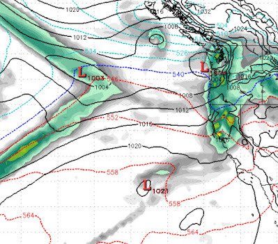
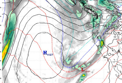
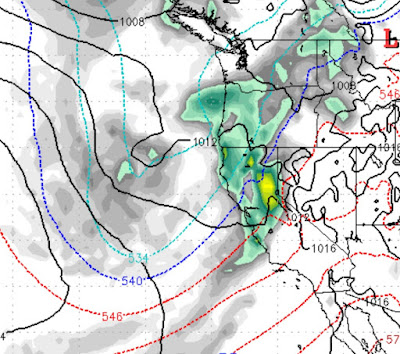
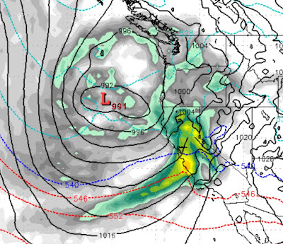
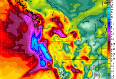
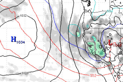
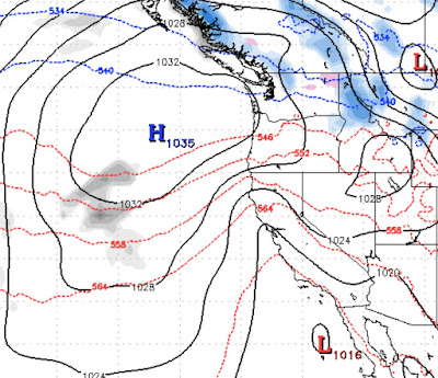
 We are tracking 4 storms starting late next Thursday, February 11th. Between now and then, expect above average temperatures. Then everything changes. The weather models are mostly in agreement about this next storm series so despite it still being 5+ days out, we are very confident. Here is a look at the forecast for Thursday @ 10pm: Notice the complete lack of our persistent high pressure ridge. Next storm comes in late Saturday, February 13th. This one has some tremendous potential: Next storm comes in the following Monday (February 15th), about midday. Notice the moisture tail showing a true Pineapple Express event: The next storm is forecast to come in very late on the 17th of February: This next storm series should produce near consistent snowfall for over a week. Right now snow elevations look to be above 6,000 feet, but as we near these storms we will get a better idea. My gut tells me they will be higher with the sub-tropical moisture that all these storms are tapping into. W

Small Storm Tuesday; High Pressure to Dominate For Next 7-10 Days

Image
 We have a small system coming through on Tuesday. That will be the last storm in the current storm cycle. After Tuesday look for above average temperatures for at least the next 7-10 days. Here is a look at the forecast for Tuesday around 10:00am: Notice the massive ridge of high pressure out in the Pacific. That ridge will begin to dominate our weather for at least a week and probably more. This last storm will bring 4-8 inches to the Carson Range and other Tahoe resorts. Stay Tuned ...

Storm Winds Down Friday Morning, Next Storm Late Monday, Then Dry and Warm

Image
 Ma Nature is showing off! Our current massive storm has shifted north again and should add a least a couple more feet of snow to the Carson Range, which has already seen over 4 feet. The next storm comes in late on Monday and is taking dead aim at Tahoe: I would expect that we will pick up another 12-24 inches from this next storm. That should bring the total amount of snow for the week to around 100 inches for Mt. Rose. That should open all remaining terrain. However, this storm cycle is over after Tuesday. High Pressure will dominate our weather and bring much warmer than average temps to the area. Notice the warm air, in this next chart, extending all the way into BC: This is the forecast from the GFS weather model, the EC model is saying we will NOT get that warm. The next storm cycle looks to start around the 13th of February. Stay Tuned ...

2 Storms then High Pressure Takes Over

Image
 This is a very typical La Nina pattern. La Nina can spin up some large storms but there are usually far fewer storms in a La Nina year. We have two storms that the models have consolidated on. They are backing off historic snowfall amounts. From Kirkwood to Mammoth will see the most snow. In Tahoe, we will get our fair share, but not what we were predicting even a few days ago. The first storm is just making landfall in Northern California now. This is the larger of the two storms. It will begin to affect our area about 10:00 tonight, Tuesday January 26th. It will have two peaks, tomorrow at around 4:00am: Then the next peak will be Thursday around 10:00am: The second storm we are tracking, and for now what appears to be the final storm in this series, will arrive on Monday morning and last for about 12 hours as it weakens: Combined these two storms will produce in neighborhood of 4-8 feet, with the Carson range getting around 4 feet as we are seeing some shadowing occurring. You can

Tahoe to get Slammed With Epic Snowfall; Heavy Snow Expected For the next 2 Weeks or More

Image
Before we get into the weather forecast, please visit  Unofficial Mt Rose , it could save your life. If you are thinking about heading into the back country, please read Sven's post as dangerous Avalanche conditions are setting up.  If you have been reading our posts, then you are well aware that the models converged on an epic snowfall for the Tahoe area. We are tracking large storms as far out as 2 weeks. Here is the latest precip forecast for the next 2 weeks: All resorts in Tahoe should receive between 8-15 feet of snow depending on elevation and location. The chart above is calling for the Carson Range to pick up around a foot of liquid precip. With these storms being a bit on the colder side, we believe in the next 2 weeks Mt. Rose could see as much as 12 feet of snow. With the snowpack down below 50% this will be a great help. In addition, at the present time, we are seeing the storm door remaining wide open. Here is the forecast for February 9th, notice the ridge of high pr

The Year's First Major Storm Cycle is Knocking at the Door

Image
Could we finally be about to start a storm cycle that will bring more typical Sierra storms to the area? Well, if you believe the models, YES! Storm 1 (Friday 1/22 - 1/23) This is a very light storm that could attempt to overachieve. It will send several weak waves of precip into the area and produce by days end Saturday 1-3 inches of snow. Better than nothing. More importantly, it will nudge the ridge of high pressure further west which will open the storm door for bigger storms. Storm 2 (All day Monday 1/25) This is a better storm but still not what we are looking for. However, we see 6-12 inches for the Carson range. Storm 3 (Wednesday 1/27 - Friday Morning) This is a storm with some potential, it is still 6 days out but the weather models are consolidating on our first major weather event, complete with a subtropical moisture tap (18-36 inches) Storm 4 (Sunday January 31st - Tuesday February 2nd) This one is a beauty. It has all the makings of a major winter storm. It is a tad warm

When Will it Snow Again?

Image
 High Pressure is in complete control making for very mild days. Unfortunately, in a year that has seen much below average precipitation, that means what little snow we do have is melting. Here is a view of our current conditions: You can clearly see the warm air has moved almost to the Washington State border. That begs the question; When will it snow in Tahoe again? We will see a small system come through on the 22nd and bring much needed cold air with it. The effect this system will have on our weather will be seen, however, in the days following the 22nd. It is going to nudge our ridge of high pressure west just enough to allow the storms to start dropping out of the north and bring in a very welcome change to our weather pattern. The first decent storm in the series will be around the 25th of January: Notice the ridge of high pressure has moved well west, opening the storm door. Here is the forecast for late on the 26th of January: We believe there could be several more storms in