Posts

A Couple of Near Misses in the Next Two Weeks

Image
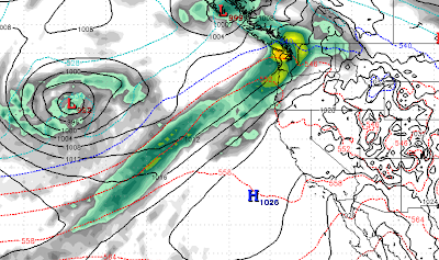
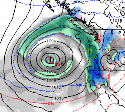
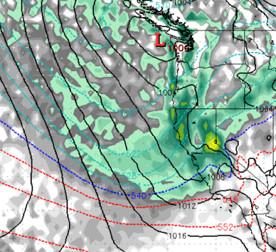
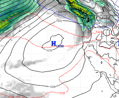
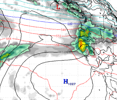
 Wow, Ma Nature is really being fickle here. Our persistent ridge of high pressure is being bounced around, but will still block any major storms from reaching the area for the next 10-15 days. Here is a typical example, notice the ridge providing a perfect block from storms making it into Tahoe: We will return to much cooler air in about a week as well as an Arctic Front makes its way down and gets far enough west to effect our area. At least the Pacific NW is getting storms now. That could bode well for the 2nd half of March. Mt. Rose is up to 300 inches of snow for the year, which exceeds most predictions out there. Of course we predicted 330 inches for this year and that guess is starting to look eerily similar to last year. Perhaps next year we will predict 600 inches! Stay Tuned ...

March Miracle or Madness?

Image
A couple of slider systems will continue to effect our weather over the next 10 days or so. We are still seeing a pattern change continuing into March with storms coming down the coast as opposed to the Eastern Sierra. Those storms have much greater potential. We can expect a repeat of the slider we had earlier in the week. That system will come though on the 21st and 22nd and should bring more snow to the valley and the Eastern Sierra / Carson Range. These systems also bring in much cooler air. Then around the first of March we are seeing the ridge moved north and west. That should open the storm door. Right now the models are not showing any consistency. For now our confidence is not very high, but at least there is a chance for March to come in wet. Sorry, that's all I have for now. Stay Tuned ...

Major Weather Pattern Change to Arrive Around the 21st

Image
We alluded to this pattern change in our last post. The models are converging and even the NOAA long range forecast is calling for a likely stormy pattern heading to the entire West Coast starting on the 21st and lasting into March. Here is a look at the forecast for the 21st. This is the first in a series of storms as the polar ridge that has brought the Central and Eastern US into the deep freeze starts to break up. We know this is a ways out, but our confidence is very high for a number of reasons. Mostly, many of the weather predictors (AO, MJO, etc) are all pointing toward this event. In addition, the ECMWF Long Range is now forecasting this. This from NOAA, the last bullet point is most relevant to us: In addition, the AO is moving to a negative phase which bodes well for stormy west coast weather. So enjoy the next 10 days of high pressure as things are going to change rather dramatically.  March Miracle? Maybe! Stay Tuned ...

When Will it Snow Again?

Image
After record breaking snows in December, Ma Nature has turned off the spigot. Why she decided to do that, we have no idea. So, will it ever snow again in Tahoe? I know that is a ridiculous question. Of course it will.  We took out our long range Crystal Ball. We looked long and hard for a pattern change. We see one coming on or about the 3rd or 4th week of this month. Between now and then we could see a couple of weak sliders. One of the culprits for this weather, is a huge ridge of high pressure extending from northern Canada down all the way to parts of the southern US. It is keeping the northern plains in the deep freeze and blocking just about everything. That is giving free reign to our persistent ridge to setup off the coast and channel everything north. We need that ridge to move west, which should open the storm door again. Around the 3rd of 4th week of February, the long range forecast has that ridge moving west: As you can see, when that happens storms fill the void and make

A Couple of Glancing Blows; No Major Storms for at least Next 7-10 Days

Image
Our persistent ridge of high pressure, after being tossed around like a rag doll, is making a comeback. We have a few glancing blows that for the most part will be blocked by said ridge. The first is late Monday night (1/3), early Tuesday morning: Notice that blocking ridge to our south. We will get a glancing blow at best, perhaps 6 inches of snow up at Mt. Rose. The next is Friday (1/7) in the morning: Again, another glancing blow. The good news, these smaller systems should mix up the air and prevent a long, drawn out temperature inversion.  Temperatures will fluctuate, but we still see high's in the 50's for valley locations starting Thursday. Not much else happening, Happy New Year! Stay Tuned ...

High Pressure to Block Large Storms

Image
After a record breaking December, the models are backing off a major weather event next week. A ridge of high pressure is the culprit. We thought that ridge would be moved out, obviously it had other ideas.  Here is the forecast for late on Tuesday January 4th. Notice the ridge of high pressure to the south, that will close the storm door for the Tahoe area: We are looking at 6-12 inches of snow for Mt. Rose Tuesday into Wednesday.  We are seeing much warmer temperatures with high's in the 50's in some valley locations. By the 6th of January, I would expect to see temperature inversions in place as well. This pattern will start around the 6th and should last for at least a week. Stay Tuned ...

Some Clearing Expected Ahead of Massive Storm

Image
It turns out that Ma Nature does NOT have that great a sense of humor. Sure she sent a snow storm to the Global Warming Summit a few years back, which made it much more difficult for the planet saviors to land their private jets. Imagine the problems with Limos and Tire Chains? Those poor billionaires! I received an email from a person that the ski resorts would soon be suing the oil companies for lack of snow. I simply replied back that therapy must not be working, perhaps medication would be more effective for his condition. Mt. Rose has received over 200 inches of snow in the last 2 weeks and it is still snowing! That is how nature works. In the span of a few weeks we can catch up to our averages. Remember there is no normal when it comes to weather or even climate. Having said all of that, we are seeing an end to this latest storm cycle approaching: Here is the forecast for late Thursday.  We believe the snows will stop by Wednesday morning as this ridge creeps east and provides a