Posts

Showing posts from 2015

One More Storm, Then Cold, Dry Period
Image
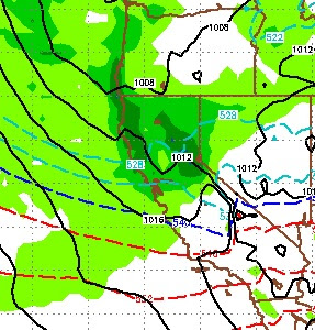
We have one more storm on tap. That storm will usher in very cold air and move quickly through the area. Unfortunately, this storm is moisture starved. Here is a look at the forecast for about noon on Christmas Eve: This storm will quickly exit our area and leave behind very cold air and very deep valley inversions, especially this coming weekend. Winds will not be nearly as strong and there is a good chance that the lifts keep spinning on Christmas Eve day, during the storm. With the heavy snow we received over the last several days, Christmas day could bring a champagne powder day. For all things powder, be sure to visit the best Mt. Rose site:  Unofficial Mt. Rose , they will let you know if the lifts are spinning and the kind of conditions that can be expected. I am expeciting 6-12 inches of very light powder for the Carson Range starting around 8:00am on Christmas eve and ending that evening. I see a lot of cold and no major storms perhaps through the end of the year. Howev
Warm, Wet Pattern Starts Tomorrow

Image
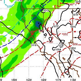
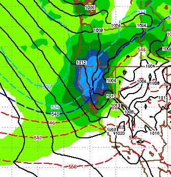
A series of weaker, warmer storms are headed our way that will bring snow to most of the Sierra and rain to the valleys. The big question is how much snow? My answer is: A lot. First allow me my disclaimer, the models are all over the place, there is serious moisture available for any storms headed our way and there are several storms poised to hit. The first of these systems comes in late Friday or very early Saturday. That system will weaken and clip Tahoe. Most of the precip will stay west of the lake but I do expect some accumulating snow for the Carson range. Here is a look at the forecast for midnight on Friday: This will stick with us for some time as the pattern is very wet. Look for snow or snow showers all the way up to the 24th. At that time a larger storm comes in and has great potential for really hitting Tahoe on Christmas Eve or thereabouts. Here is a look at the forecast for the morning of the 24th. This storm will move into Tahoe on the 23rd, pick up moisture

Storm Update and Future Forecast

Image
A very cold storm is knocking on the door. It will bring high winds to the party as well. In fact when you wake up tomorrow morning, there is a very good chance the lifts at Mt. Rose will be closed as slide mountain could be seeing Category 4 Hurricane winds (130 mph). Right now, it looks like the snowfall will be intense but short lived. Here is a look at the forecast for tomorrow starting at around noon and lasting into the evening. There will be some shadowing effect, which will slightly limit the amount of snow in the Carson Range: This system has a very adequate moisture tap, however there are no inland systems to act as a blocking force so it will quickly move through our area. By around 6:00 in the evening here is what it should look like: Finally, here is what the EC model see's in the way of total precip for this storm: Snow levels will start at around 6,000 feet. This will be all snow for all of Tahoe. The western shore ski areas will get the most snow o