Posts

Showing posts from 2017

Slider Will Usher in Cooler Air; Coastal Ridge Digs Deeper

Image
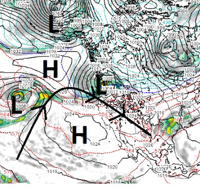
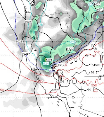
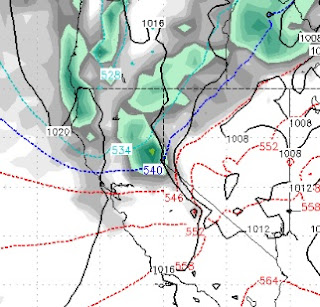
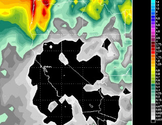
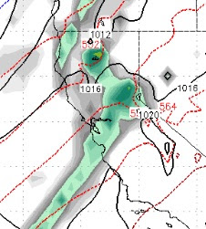
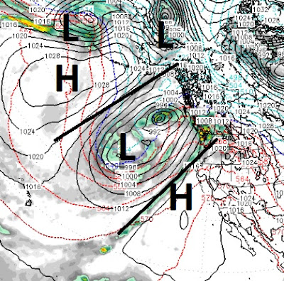
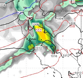
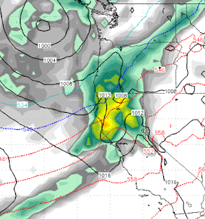
The cold front we talked about last post is right on time and we are sticking with 8-16 inches of champagne powder for Rose. The deeper the less likely for skiers and riders to break through and scrape the crust underneath. I am fairly confident we are looking at a good 10 inches and if things go just right up to 16 inches. Then the ridge digs deeper. The coastal ridge in the jet is causing storms to go well north of us. This storm for tomorrow is due to that ridge flattening out. Here is a look at tomorrow: One sneaky little trough in the jet is going to allow this moisture starved slider to drop in straight out of the north. However, there is a substantial cold front associated with this storm and snow ratios could hit 15-20 to 1 depending on the timing of the moisture and cold air. The above graphic shows the ridge of high pressure in jet stream. This is causing all weather to move north around the ridge and will keep us high and dry for some time, unfortunately. Here is a

Finally, Changes in the Forecast

Image
With our ridge of high pressure getting pushed slightly west, that opened a very narrow door for what we call a slider storm. That is a storm that comes from the north and east and slides down the leeward side of the Sierra. Usually, these storms have very little moisture but they always bring cold air. In this case, we finally got some winds in the valley to change the air and clean it up. That was the first sign that we are starting to see a pattern change. The next sign will come this Wednesday in the form of an actual storm. Not a big storm or even a moist storm, but a storm nonetheless. Although this storm will come from the north and west, it will be more north than west and will bring in even cooler air. Here is a look at the forecast for Wednesday @ noon: What we like to see is for these storms to tap into an active moisture plume from the south and west. As you can see this storm does not have much moisture to work with. Here are the forecast precip totals: This wi

Large Ridge of High Pressure to Continue to Dominate our Weather

Image
A very large ridge of high pressure will continue to dominate our weather for the next 5 days. Around Thursday that ridge will begin to flatten which will allow unsettled weather and minor troughing to take place just before next weekend. We could even see an inside slider, but at very least we will see some wind make it down to the valley floors and mix up what will become some very poor air quality. If you live in the mountains, it is going to be a beautiful week. Here is what we are up against. Notice the ridge of high pressure and how steep it is. Basically folks, that is the jet stream and all storms are going to go right around the ridge: This ridge is also keeping pretty cool air in our area as the rotation of the winds is clockwise which is bringing cool air down from Canada. Somewhere around Thursday and into Friday, the ridge will begin to flatten out, which should allow some minor troughing to come into our area in the form of wind and even possibly a little snow

Strong Cold Front Knocking on the Door, Pattern Change Around Christmas?

Image
A well advertised, strong cold front is knocking at the door. Although this front does not have much moisture to work with, we believe that the Carson Range could pick up 3-12 inches of snow as the precip potential has increased. Our confidence is much higher with 3 inches than 12 inches. Here is a look at the peak of the storm which will be about 4:00 am Sunday morning: The clash of warm and cold air is giving us some hope of a surprise and this storm may squeeze a little more precip than the models are suggesting. After this storm passes, it is back to ridge city. Temperatures will slowly recover, but look for pretty deep valley inversions and crappy air quality next week. If you live in the mountains, it will be beautiful and the skiing up on Rose should be great as they have done a great job managing the snow and giving us pretty smooth, fast conditions. It seems as though every weather outlet has hopped on the dry winter bandwagon. Of course we have been talking about thi

Strong Ridge of High Pressure to Continue to Dominate our Weather

Image
High Pressure has moved in off the California coast. That is blocking any storms from coming into our area. It looks like this high pressure ridge is going to camp and stay put for at least the next 10 days and probably longer. I just read a post from the NWS that said they are looking for a couple of scenarios over the weekend to bring snow either in the form of a decent storm or inside slider. Folks, I just checked both the GFS and EC weather models and I see nothing in the way of significant precipitation coming our way. In addition, our expert Meteorologist Paul Huntington has hinted at the possibility of an extended dry period. One thing we are seeing is cooler weather coming in on Sunday and lasting through the following week. That should allow ski areas to make snow and should bring our first real taste of winter. Here is a look at the total precip forecast for the next 10 days: The models had been hinting at a precip event for next weekend, but they have backed off of

Mild Weather Until Saturday, Then Major Change

Image
Our mild weather will continue through most of Saturday. Then, a strong cold front will move down off the Oregon coast right through the Tahoe area by Sunday. This cold front will bring snow and extreme winds. The snow will affect commutes back from the Thanksgiving Holiday. The precipitation should get started in the Sierra early Sunday. The heavier stuff comes in around Sunday at noon and should bring moderate precipitation until around Monday at noon. Here is the forecast for Sunday around noon: Six hours later, around 6:00pm (Sunday) the storm will have increased in intensity and snow levels by then should be down below lake level: The storm continues to strengthen into early Monday morning: This storm does have some moisture to work with, here is the precip forecast: We are forecast 1-2 feet of snow for the Carson Range which will be a very welcome addition as the base has taken a real hit with these mild temperatures. High pressure moves in behind this sto

High Pressure, Mild Temps to Dominate Our Weather for the Next 10 Days

Image
Our persistent ridge of high pressure is becoming more persistent. It will camp right off the coast of California and push the storm track north of us. There will be slight chance of very light precipitation off and on for the next 10 days, but we see no major storms or precip during that period of time. Here is a look at the current conditions. You can clearly see the storm track moving well north of Tahoe. As we move into the week, the ridge actually strengthens and moves north, pushing storms even further to the north. We talked about a dry period coming up, well this is it. The 30 day hinted at very mild weather. That big storm from last week certainly saved the early ski season! Here is the 30-day forecast which says that the models believe the storms will return. Looking a little closer we could be talking about late in the first week of December: I just wanted to give a shout out to Taylor at Bobo's for helping me with an equipment problem yesterday. Bobo&#

Three Large Storms Poised to Slam Tahoe

Image
This is some crazy weather as the models have been changing as often as most of us change underwear. A very large, wet storm is knocking on the door right now. For now it looks like the snow level is holding around 8,000 feet. We are looking at the possibility of 6 inches or more of liquid precip before this storm moves on. That means that 2-3 feet of very wet (base creating) snow could be sitting on Slide Mountain by noon tomorrow. The possibility does still exist that snow levels rise, but at this point it seems unlikely. In fact, they should start to fall rapidly as this storm has a very cold air mass associated with it. Here is a look at the forecast for 4:00am tomorrow morning: That is a pretty impressive moisture tail stretching down to the subtropics. That will fuel this storm and make it a very large storm, especially for pre-Thanksgiving. The next storm arrives around noon on Monday. Here is the forecast for that time: Not as impressive a moisture tail, but this

Storms Update

Image
The storm for Wednesday/Thursday has picked up strength and has a very adequate moisture tap. The storm for Saturday is now just a small short wave off the main storm system and will miss us to the south, the storm for next week is looking warm and moist as well. In a nutshell, the storm machine is beginning to crank. We have a very warm and wet storm with a sub tropical moisture tap set to hit Tahoe head on. That will show up late on Wednesday and not clear out until late Friday. Here is a look at the forecast for very early Thursday morning: As this storm pulls moisture up from the south, it will also be pulling very warm air up. I was hoping for a cooler system but that is not going to happen. It now looks like this will start as heavy rain up to about 9,000 feet. As the cold front passes through, snow levels will drop rapidly but I fear the bulk of the precip will have already fallen. There is a chance that snow levels could hover around 8,000, but right now this storm is t

Wet Week Ahead?

Image
By Paul Huntington Here are the totals from the California Nevada River Forecast Center for the mid November series of storms-one more lining up for Sunday night also- i predicted in the Winter outlook post and appears Rose is in the bullseye. It will be interesting if the wet pattern continues into December or we get a break like i was predicting. Nevertheless, I am surprised we are getting an atmospheric river storm this early in a fairly strong La Nina year and will be interesting if it holds together. cheers to Tahoe resorts opening, Paul H.

Slight Pattern Shift to Wetter, Warmer Storms

Image
We are seeing a pattern change develop. Up until this point our storms have been born in the north and come through Tahoe with very little moisture to work with. Perhaps you remember last year when the storms came down and tapped into a very active moisture plume and brought record snow to the Sierra and record rains to Northern California and Western Nevada. We are seeing a similar, albeit not as powerful, pattern begin to develop. What does that mean? More snow for the Sierra with warmer and wetter storms. We are currently tracking 3 more storms in the next 10 days with what looks like more storms stacked up behind them. The first storm should show up in Tahoe on around 2 pm on Monday (10/13): This storm will be similar to what we have been getting, with little moisture, lots of wind and a cold front behind the leading edge of warm air. Again, we look for this to start at about 7,000 feet and work it's way down. We do not expect a major snow event, but we will take what we

Two More Storms Headed Our Way

Image
I was not in town for this most recent storm, so I am not sure how it played out, but from what I saw it was somewhat disappointing. Fear not for we have two more storms coming in for Thursday and Friday of next week and then late Sunday (week from today) through Monday. These next two storms look pretty good, have a much more westerner trajectory and should have more moisture to work with. Here is a look at the forecast for Wednesday night as the first storm approaches: Our weather will stay unstable until the second storm comes in. There is at least some chance (cross your fingers) for a more decent weather event between these two systems. If the first storm stalls just a bit and the second storm slams into it and lingers, then we could have one stormy week starting next Thursday. However, right now it looks like two moderate (at best) weather events separated by a few days. Here is the forecast for late Sunday (11/12) night when the second storm arrives:  Pretty

Small to Medium Storms, Followed by Two Weeks of Dry?

By Paul Huntington This next storm appears to be a mediocre medium size storm. I'm seeing a dry mid late November along with the Climate Center seeing that trend also and is appearing like a spotty Winter storm wise with strong ridging dominating for majority of it but anything is possible nowadays with our extreme climate. The quiet ITCZ along the equatorial Pacific ocean and negative PNA phase is very supportive of a drier air mass over Central California when the long wave trough shifts east and could be a Winter with a spatial pattern of 4-7 days of rain/snow and then two weeks dry sort of thing and repeating that cycle through its entirety. Stay Tuned ...

Winter Starts Again on Friday Morning

Image
What a beautiful stretch of weather we are currently enjoying. It's not over yet, but the end is near. We have a strong low pressure system that will work its way down from the Washington coast and bring a very stormy period to the Tahoe area. I see the period lasting from very early Friday morning through Sunday night. This storm will effect most of the state of California and does have a pretty adequate amount of moisture from which to work. Here is a look at the storm at it's peak on late Saturday night: This storm will tap into sub-tropical moisture and come in pretty warm. Hard to say the snow levels, but my guess is around 8,000. However, this storm will usher in a much cooler air mass and snow levels should drop at or even below lake level in time for the main precipitation event starting Saturday afternoon and lasting into Sunday. Here is a look at the precip forecast for this event: Finally, here is a look at the 384 hour GFS precip forecast, sent in by o