Tricky Weather Pattern Emerging
As the first storm in our 1-2-3 punch approaches, models are pretty consistent. The Sierra will pick up some snow but it will probably be amounts in the low range of my forecast earlier in the week. On the heels of this storm comes another for Sunday and Monday. Again, this storm looks as though it will develop a north to south trajectory and snow amounts again will fall into the lower range. To fine tune the forecast, I am now looking at about 1-2 feet of snow by Monday evening, likely in the lower range.
The real tricky development comes Thursday of next week. The GFS model has a huge storm moving south and west right into our area. However the EC model has the storm moving south and getting trapped out at sea and having little to no effect for our area. Here is what GFS shows for early Thursday:
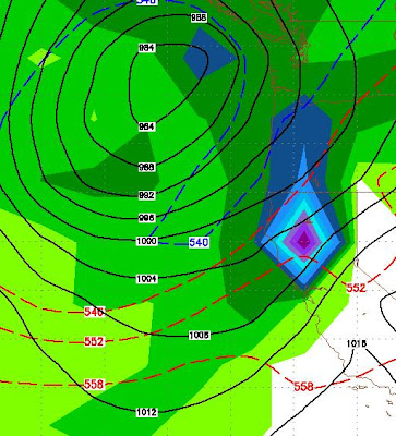
Again, EC could not be more in disagreement with the GFS model shown above, here is what EC believes will happen to this storm:

If GFS is correct, we could be looking at 3-5 inches of liquid precip. That could translate into 2-5 feet of snow for the Sierra around Lake Tahoe. Incidentally, the NWS is leaning toward the EC model and believes this storm will trapped well off the coast as it moves south and out of our area. Disclaimer: This is a long way out and nobody really knows what will happen ... so cross your fingers.
Looking way down the road, conditions look to calm after the 3rd wave in our current pattern. However, that is a long way off. I will keep an eye on any future developments and especially the potential for a decent sized storm for late next week.
Stay Tuned ...