Last Storm in Series Hits Tonight; High Pressure Blockage for Next Week
The last storm in our series of storms will hit the Tahoe area tonight. Here is a look at the storm as it approaches the west coast:
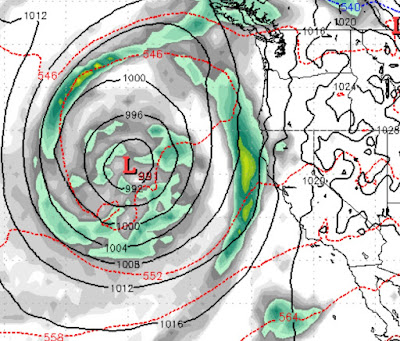
With the due west trajectory of this storm, it is going to come in warm with snow levels hovering around 7,500 feet. It is also has a tropical moisture tap which will bring in very warm, moist air. Probably best of all, for us valley dwellers, it will finally mix the air so the fog can lift out of here. We will start to see the impact this afternoon as high level mixing occurs.
This storm will pound Tahoe through Sunday afternoon and will leave 2-4 feet of base making, wet snow in it's wake.
High Pressure with then move in behind it. The storm machine will remain very active, but not for us. At least not for a little while as some giant storms will attempt to push the ridge out of here and reopen the storm door in about 10 days.
Here is a look at the blocking ridge for next week:

Our friends up in Portland and Seattle can expect some very rainy weather as our ridge diverts the storms right through the Pacific Northwest.
Stay Tuned ...