Posts

Massive Cold Front To Dominate Our Weather - Dangerous Wind Gusts Likely

Image
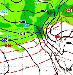
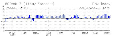
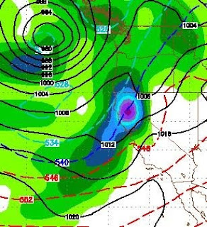
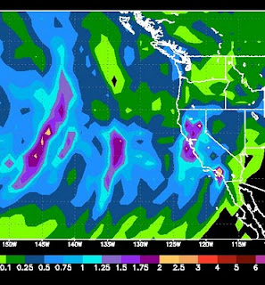
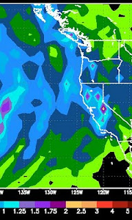
There is a very large storm well north of us that will be sending some very cold air our way today, tomorrow and Wednesday. Along with that cold air, we could see our windiest conditions in a number of years, especially on the leeward side of the Sierra in the foothills. Places like Galena Forest and Arrow Creek. Accompanying this cold front is a pretty nice sized winter snow storm. It will spill over and snow all the way to the valley floor, heavy at times after the cold front comes through late Tuesday. Take a look at Tuesday afternoon: This snow event, which should bring 2-3 feet to the High Sierra, will last about 36 hours in the mountains. Here is a look at liquid precipitation levels: The western side of the Northern Sierra around Lake Tahoe could receive as much as 4 inches of liquid precip. Mt. Rose could get 18-24 inches of nice light powder from this event. Wednesday morning could be quite a treat for those of you who can make it up the mountain. Dangerous Winds Com

PNA Turning Positive, Weather Should Turn Nice

Image
The NOAA PNA is forecasted to go strong positive which should mean strong ridging off the coast and very nice weather for our area. Have a look: High Pressure will dominate our weather through next weekend. A weak system will come through tonight (Saturday) and another on Wednesday. High Pressure will setup to our south and west which will act as a blocking force and push the storms north. Expect highs in the 60's starting around next Thursday. For now it looks like a beautiful next weekend. Get those sticks (golf) out and start swinging as spring is here. Having said all that, we still have a moderate El Nino. Our pattern is going shift, but we have at least a couple more shifts back down the scale to prolonged stormy weather coming. There is an excellent base of snow out there. This is a great time of year to ride or ski in the morning and golf in the afternoon.

Stormy Week Ahead. Big Storms For Next Week?

Image
We have a series of small storms that will affect our weather over the course of the next week, starting on Tuesday. Another band comes through on Wednesday, Friday, Saturday and Sunday. We will then get a little reprieve before a much larger storm comes calling. All week looks excellent for riding and skiing conditions. On or around March 10, GFS has this storm slamming us. A similar storm could also hit us 3 days later: El Nino has weakened, but is still firmly in control of our weather. I would expect this to be a very turbulent spring with summer arriving late. As these storms approach from the Gulf of AK, I will keep an eye on them and report back to you!

Ready or Not, Here They Come

Image
The current pattern will continue for at least the next 10-15 days. There will be nice days surrounded by very stormy days. A very impressive storm is coming in Friday and Saturday that should dump 2-4 feet of snow in the Sierra. The NAM model shows this in the way of liquid precip, notice some areas of the Sierra could receive upwards of 4 inches, which could translate into 3 or more feet of snow:   Looking ahead, we will have a few nice days to start next week before the next system comes in late Tuesday through Wednesday. Looking way ahead, a series of larger storms appears poised to hit us starting Saturday, March 6th and possibly lasting through all of the following week ... but let's not get ahead of ourselves. These systems appear to be rain for the valleys. Couple that with warmer March weather, and the golf courses should be coming back online soon. Stay tuned ...

Nice Weather - Don't Get Used To It

Image
As I wrote about a week ago, things are looking really nice for this week. The valley's could start to push 70 by Wednesday or Thursday with sunny skies and reasonable winds. Enjoy it while it lasts, because it aint lasting long! A number of factors are starting to come together that should provide a fairly sustained period of very stormy weather starting this weekend and lasting into the foreseeable future. Without getting too detailed, the high pressure ridge will move east and the vacuum will be filled by a sub-tropical jet which will bring storms to all of California and the Sierra. Here is an interesting chart. This is the total precip from Sunday to Tuesday. Which should get a healthy shot, but look west. All that is heading our way as well:   Here is a look at a GFS chart for Sunday morning: The storm track should come right over Central California. Not getting too far ahead, a rather large storm looks poised to hit us on March 1, with several smaller storms co

Spring Like Weather Is Coming - El Nino has passed its Peak

We have a cold little system that will be moving through Tuesday and Wednesday. It will bring minor amounts of snowfall, < 12 inches for the Sierra. The models and the PNA forecast suggest that a weather pattern change is coming. That change is for much warmer, dryer conditions starting as soon as Thursday and lasting for perhaps a week or 10 days. There are some indications that a much larger storm could be in the works around the 20th of February. However, this year has been nearly impossible to predict weather. In fact the Reno NWS folks oftentimes have trouble predicting what will happen in 6 hours, let alone 2 weeks. I will keep an eye on that one. In the meantime, polish up those clubs as we could see some 60's not too far down the road. Meanwhile, NOAA is suggesting that El Nino passed it's peak in Late January and beginning to weaken across the entire equatorial Pacific, especially in the mid-pacific regions. The site when on to say that we should expect neutral co

Decent Storm for Friday and Saturday - Nino Coming Back mid-February

Image
Another decent sized storm is headed our way starting Thursday night and lasting through Saturday. There are a series of very weak disturbances that will come through leading up to this event. First here is a moisture chart for this weekends storm:   Most of the Sierra is poised to receive 1.5 to 3 inches of liquid precip. I should say this is the GFS model, which consistently under predicts moisture totals. My gut tells me the storm will produce around 18-36 inches of snow for most of the Tahoe Sierra, with a larger band down around Kirkwood. Here is a look at the storm as it approaches Thursday night. It is a decent sized storm coming ashore to our north: As it looks today, the best time to hit the pow will be on Saturday. But conditions should be excellent Friday through Monday, especially in the back country. Keep an eye on the avalanche conditions before setting out. You can check them here: Sierra Avalanche Center Looking longer range, the models are starting to point a