Posts

When Will The Party End?

Image
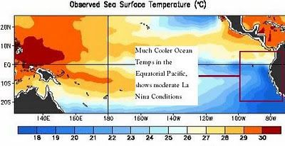
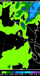
At Least Two More Weeks of Near Perfect Weather For winter enthusiasts, these may be the worst of times. Trust me, there will be plenty of winter coming our way. Just not any time soon. We are looking at another 15 days with high temps around the mid-80's with  little variability. Our cool days will find highs in the mid-70's. There is literally no chance of any precipitation over the next 2 weeks, so expect an abundance of sunshine. Right now our weather is the best in the country and looks to stay that way for some time. La Nina Affect What a difference a year makes. Last year we had mountain snow during the Street Vibrations event. I remember thinking about all those cyclists that came here and how cold it was. This year, the temperature was in the 90's with beautiful clear skies. What is the difference? That's easy; last year was an El Nino year, this year is the exact opposite, a La Nina year. La Nina is the culprit. La Nina is a cooling anomaly in the equat

Back After Summer

Image
Hello fans of the Tahoe Weather Blog. I am back after a very busy summer. Please notice the new look of the site and comment as you see fit. I unfortunately have not had time to blog about global warming, but plan to during the year. As we move through September, I am sure many of you have noticed changes in the weather. We know what is coming and this is the place to look for long term weather forecasts for the Northern and Central Sierra. Looking slightly ahead, we will have some cooler weather today and tomorrow that could bring some precip to the mountains with snow flurries in the highest elevations of the Northern Sierra (Tahoe) and perhaps 2-4 inches of snow above 10,000 feet in the Central Sierra (Mammoth, Yosemite). Here is a quick look at the accumodel for 84 hour precip: The Central Sierra could pick up as much as a half inch of liquid precip. At the high elevations that should be snow. Going to be a cool, wet night for the campers in Yosemite and the back country arou

One More Day, Then Move Toward Stable Summer Pattern

The storm for next Tuesday has fallen apart. It will only have a mild effect on our weather. After today, it looks like we may start to finally move into a more stable, summer pattern of weather. That pattern builds a huge high pressure ridge off the California coast and we are dominated by warm sunny days. Looking ahead, we will see some 90's toward the end of the first week in June. That will signify that we are in a summer weather pattern. After that, you won't hear from me again for a while. Once we get there I will educate this large 30 person audience about "global warming" or more realistically, climate change. Just a little hint: If you want to know how the global warming hysteria has become so out of hand, follow the money trail. There are billions in grants out there for "scientists" to uncover evidence of global warming. There are no such grants available to refute it. Enjoy the nice weather!

Very Stormy Week

Starting tomorrow afternoon we should have about 4 days of clouds, rain and cool weather. The mountains will get a fairly healthy dose of snow. Memorial, however, is looking dry, but cool with highs in the mid-70's at best. Then another storm comes in the Tuesday after memorial. The storm I talked about last week has held together nicely and is poised to move into Northern California on Tuesday. This storm will hit the Sierra Tuesday afternoon and affect our weather until about Friday afternoon. It will bring cooler than average temperatures to the entire region. The valley's will pick up about 1/2 inch to an inch of rain over the next 4 days and the mountains will get about 1-3 inches. That could translate into about 18-24 inches of wet snow above 7,500 feet.

Our Crappy Weather is Going to the Next Level

Image
Giant Cold Front for this Weekend We are going to see some very cool temps this weekend as a strong storm that is slamming the Pacific Northwest moves on shore. The backside of that storm is going to whip northwest winds down the coast and right into our area. The high for Reno on Saturday will probably not get out of the 40's. There will be some light snow associated with this cold front. Here is a look at Saturday's weather. Take note of the black lines as they form a corridor straight out of the north. The blue circle represents a very significant cold front for this time of year: Strong and Frequent Storms for Next Week The weather models are predicting a very stormy pattern for next week. A series of moderate storms are headed our way. This will mean more mountain snow. Incidentally, I am not aware of a ski area still open in Tahoe. Many closed with a 15 foot base. Mammoth is still open and they continue to have unbelievable May conditions. Here is what we are look

Weather to Turn Stormy and Windy

Image
The headline says it all. We have a decent sized storm coming into the area late Sunday and lasting until midday Tuesday. This will bring some rain to the valley and a decent amount of snow to the mountains around Lake Tahoe. Here is a snapshot for Monday evening: Along with the stormy weather we will have much cooler temperatures and very windy conditions. Both Sunday and Monday will see wind gusts in the 50mph range. Next Friday, ahead of another storm, winds could be clocked in the 60-70mph range. Everyday for the next couple of weeks should have very windy conditions. Temperatures will vary as a number of storms enter and exit our region. Ahead of the systems, we will see reasonably warm temperatures. When the systems exit the temp will drop significantly. The models are tracking a much larger storm for a week from Monday. Of course that is very far off, but here is what they see for May 17: This is a very large storm for this time of year and could bring copious amounts of

Ugly Forecast

Image
High's in the 50's and Low 60's For At Least a Week Did I mention how difficult it is to forecast weather this time of year, especially with El Nino sitting out there stirring up trouble? Well, in complete defiance of my Friday post, which called for nice weather ... things have changed rather dramatically. Enjoy today, because this will be as nice as it gets. You will notice the winds start to kick up this afternoon, then our weather will be heavily influenced from the north. Which means cool temperatures and very windy ... for perhaps the next 12 days. This all culminates a week from today with what appears to be a pretty impressive storm for our area. We could see heavy mountain snows and valley rain. Here is snapshot for next Monday: If this holds, that is quite impressive for this time of year. Remember, however, things can change. Windy Windy and more Windy We should have decent winds every day into the foreseeable future. High winds (50mph +) are forecast for