Posts

Storms Done For Next 10-14 Days

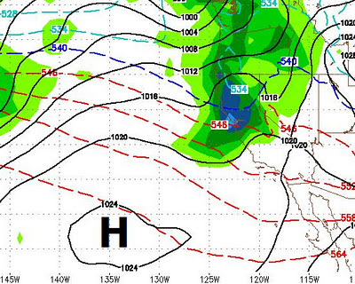
We had some pretty impressive rain totals. Main areas of the Sierra crest picked up 6-10 feet of snow at the very highest elevations. Some areas saw nearly 10 inches of liquid precip over the course of the last week. All of that was much needed. However things are going to dry out for a while. The ground moisture content is very high, so expect some fog for the next few days. Also expect a big warm up. The nearest I can see in the way of a storm cylce appears to be about 10-14 days which brings almost no confidence with it. I will continue to search for storms and give you, my loyal readers, the advanced notice. Stay Tuned ...

Storm For Sunday/Monday Strengthens

Image
Next Storm The last storm in our series of storms is getting more impressive by the hour. In addition, snow levels should be around 5,000 to 6,000 feet max. The storm will crank up Sunday afternoon and last through at least Monday morning. There is now a very adequate moisture tap associated with this storm. The Sierra should pick up 1-3 feet of very skiable powder. The Carson range about 2/3 of that. Here is a forecast for 4:00 Sunday afternoon by the GFS. I am thinking the GFS is a little slow on the storm which may well get going earlier. In any event you can see the moisture tap from the west that is feeding this storm and the NWS has increased their snow totals. 4:00 Sunday (GFS) Current Conditions I went to Mt. Rose Ski area early this morning to get in a few turns. That is what I got, just a few turns. Unfortunately most of the precip from last night came in the form of rain except in the highest elevations. Lake Tahoe rose 2 inches last night as reported by the NWS. The

Storm 2 is going to start as rain below 9,000 feet

Image
Warm Air Raising Snow Levels to Start As storm 2 begins to hit the Sierra, it is mixing with some incredibly warm air. This is causing rain below 9,000 feet. However, cold air is on the way and those snow levels should drop to around 7,500 by 8:00 tonight when the really heavy stuff comes in. Mountain Should Be Open Tomorrow Morning I am not speaking for any Tahoe resort, but winds should be manageable tomorrow morning when most ski areas open. There should be a blanket of 2-3 feet of very heavy snow. That should make a nice base and allow some additional terrain to open in the coming days. Some of that snow should be groomed down and most will fall between 8:00pm and 3:00am tomorrow morning. See you up there! Stay Tuned ...

Storm 1 - Disappointment, Healthy Shot of Moisture Coming Tonight

Image
Low Snow Totals After Round 1 When the moist air mixed with the dry air, the dry air won. Both the Sierra and Carson range picked up 2-4 inches, which was less than anybody predicted. The Washoe Drive fire appeared to fall victim to wind shifts as the front moved through. Once the wind started pushing the fire back, there was nothing to burn. In any event, moderate to heavy rain tonight will end all chance of fire for now. Today's Storm Picks Up Moisture I still like the trajectory of today's storm as it comes in with cold air over warm ocean water. This storm is packing more moisture and should produce much more snow. Some of that moisture will also spill over into the valley's lessening any chance for fire. Again, strong winds will accompany this storm. Expect most of the heavy precip after 10:00 tonight. The snow in the mountains should last through most of tomorrow, although by mid morning, expect amounts to taper off. I am still guessing 2-4 feet of snow out of thi

Nice Day In Hawaii

Image
Below is our current weather conditions, yes it is a nice day in Hawaii: I am liking what I am seeing in the way of moisture and storm trajectory. I am hoping we are on the higher side of some of the forecasted precip ranges. You can see the line of storms being forced south and into our area by the blocking high pressure ridges. Stay Tuned ...

Storm Update

Image
Here is what we are looking at right now. Confidence is pretty high. Unfortunately, precip totals, I believe, will fall well short of what we expected just 24 hours ago: Thursday First wave comes in. Snow levels will be right around 6,500 feet. This wave will not have a strong moisture tap. Add that with the incredibly dry air we have right now and precip totals will be down. I am guessing the Sierra will get perhaps up to an inch of precip by Friday morning. Because of the cooler air, that should translate to around 6-15 inches of snow for most of the Tahoe Sierra and Carson range. Expect pretty high winds on the eastern range Thursday afternoon and evening - Gusts to 75mph. Friday This continues to be the best chance for significant snow. Right now we are looking at 1.5 - 2.5 inches of liquid precip. This storm is really quite remarkable. Warm air will mix with the colder surface air and play havoc on snow levels. At times snow levels could climb to 9,000 feet. However, that will

Storm(s) Update

Image
Latest Trends The good news is that the latest trends actually have 4 storms coming into our area. The trend is that the snow levels should be much lower for the majority of the event than initially thought. The bad news is that we are not looking at quite as much moisture, but overall expect a major snow event for the Sierra. The crest should pick up between 4-8 feet in the next 7 days. Right now the the upper elevations of the Carson Range look to be in that same area. Possibility Exists of Heavy Valley Snow on Sunday 1/22 The NWS is looking at a possible Tonopah Low Event. Basically this event is brought on by the weakening of the high pressure which usually prevents storms from spilling over the Sierra. This event has been known to bring very heavy snow to Western NV. The NWS is only considering this as a possibility right now. I will keep an eye on this one. Storm 1 - Late Wednesday through Thursday Windy storm that should have snow levels around lake level (6,500 feet).