Posts

Will Averages Begin to Catch Up for California? Are We Experiencing Man-Made Global Warming?

Image
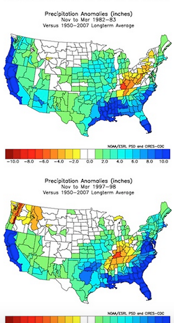
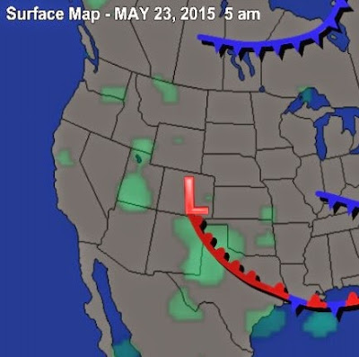
After four years of drought, most of California is under a water emergency. However, we are seeing indications that at least some relief is in sight for the short run and the long run. First, let's get some facts straight; California is mostly a desert. The drought stricken areas along the southern coast are deserts that have been radically over populated by man. We have decimated the geography by covering it in concrete and planting thousands of different varieties of non-indigenous plants. We have polluted the air and ground. In short, man has not been good to this area and there is no argument for that. The weather in this area is so nice in both the winter and summer that it is a very highly desirable place to live. Extended dry periods in deserts are not that uncommon. However, when you have over 30 million people living there they tend to be catastrophic. The San Francisco Bay area is not much different. It gets more annual rainfall (on average) than Southern California,

Sometimes Mother Nature Ignores our Schedules

Image
We are in a very strange weather pattern indeed! It has been raining for a couple of weeks in the desert, snowing in the higher elevations. Ironically, this pattern is from a series of low pressure systems that occupy the entire west right now. The real culprit is a strong storm centered near the four corners region. This storm is pulling moist air up from the south and wrapping that moisture around, right into the state of Nevada and much of the west. This storm is near stationary, so expect this pattern to continue through at least tomorrow. Unfortunately, California is being left out of this current event for the most part. When will it end? First, there is a warming trend coming as the Jet dives south and this storm begins to move north and east. However, from what I can see it is in no hurry. So I expect warmer temps (still below average) to move in, but the chance of rain will continue through next Friday, albeit nothing like what we have seen this week. After that, th

Change to Cooler, Stormy Weather Still On

Image
In our last post we talked about a potential spring storm for Tahoe. Considering, that storms do not have the power this time of year that they posses in December and January, we have a moderate size storm knocking on the door. Not much has changed since my last post as the models have held true for some decent precip coming to the Sierra and Carson range starting tomorrow and then picking up steam around midday on Tuesday. Here is the latest from EC for around midday Tuesday: I know, this looks like the same forecast I gave about a week ago, the only difference is that this is the latest model run. There are parts of the Western Crest of the Sierra that will pick up 2-3 feet of snow from these series of storms. I believe the Carson range (Mt. Rose) could should pick up 1-2 feet of snow by Wednesday night. As a disclaimer, the NWS is calling for much less snow. However, considering the latest model runs and the cold air associated with these storms (snow levels @ 5,000 feet),

Is it too late for a change in the Weather Pattern?

Image
Both EC and GFS weather models are suggesting a major spring storm could hit the Tahoe area in a little more than a week. Both models are suggesting that our first decent storm cycle in over a month is on the way for the last week of skiing at most of the Tahoe resorts. This is not, by any means, unprecedented. In fact, this has been one of the worst springs in recent memory for storms. Large April storms are the rule not the exception. Most years are good for at least one and if you believe the weather models, a storm could be on the way. Here is a look at the EC model forecast for the 7th of April: The GFS model is showing a remarkably similar forecast. Here is a look at the precip potential for this storm: Interestingly enough, the GFS has a series of storms coming in starting early next weekend and getting progressively stronger. These models have been teasing us all year with storms that do not live up to their potential. Under achieving storms, so beware. It is

Possible Snow For Early Monday

Image
A weak storm will gain some strength, come down from the north and should leave the Tahoe area with some accumulating snow. However, there will be a rain shadow at the crest which will limit accumulation in the Carson range. Here is a look at the forecast for very early Monday morning: Here is a look at the precip forecast. Most of the precip stays west of the Sierra: I am not seeing any weather anomalies headed our and we should move to dry pattern starting Tuesday afternoon. The Western Crest of the Sierra could pick up 6-12 inches by Tuesday afternoon while the Carson range will be limited to 1-4 inches. Stay Tuned ...

Weak Storms Continue

If you read my last post, you were disappointed with the storm that passed through our area yesterday. The storms are just too weak to cause much havoc, which is not totally unusual for this time of year. However, I know I am beating a dead horse, we are so due that I have been fully expecting something extraordinary. Well folks, it does not look like it is in the cards. There are a few very weak disturbances that will pass through in the next 10 days, but nothing much. Before we get too far ahead of ourselves, the weather has been very difficult to forecast these last few years. Oftentimes these weak storms can pick up some moisture or get blocked out by something thousands of miles away, and then everything can change. So let's hope that happens. If it does, you will know ahead of time. Stay Tuned ...

Storm Cycle Could Start Up Again Around the 11th of March

Image
I am seeing indications that a new storm cycle could crank up again around the 11th of March. Both the EC and GFS models are forecasting a decent storm heading our way in about a week. That could possibly usher in about 5-7 days of stormy weather. Here is the EC forecast for the 11th of March: I know this does not look that impressive, but the models have been going back and forth on just how large a series of storms will be, starting around the 12th. The GFS has been hinting a a much larger storm for our area around the 15th. Unfortunately, the models have not been able to stick with a forecast on a consistent basis. I thought I would put this out there. I will continue to track this possible event and report accordingly. Stay Tuned ...