Posts

Long Term Forecast Jan 5-12: Omega and Rex blocks dictating weather pattern

Image
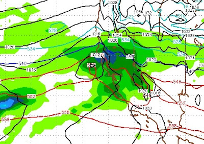
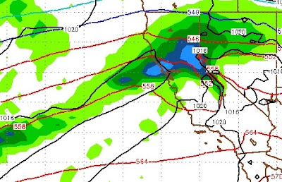
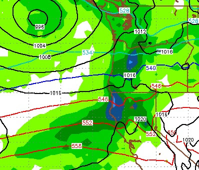
By Paul Huntington Time to bundle up everyone because Thursday Jan 5 will be down right freezing with mostly clear skies, a few passing clouds and very LOW temperatures in the teens as Arctic air plunges down from Alaska. It should be one of the best ski days in a while for higher resorts that have a larger base. This appears to be some of the coldest temperatures in a while, possibly since December 1998 when I recorded snow along the beaches of Central California! Now that we have a solid frozen base this is a very good pattern for a sustained season and water storage as the fresh snow accumulates on the established base that almost melted during the last warm atmospheric river storm but has now refrozen into a thick slab of ice (lower elevation resorts like Bear Valley, Sierra Summit, even Sugar Bowl did not fair well with the warm storm though and be very careful about hidden rocks under fresh light snow!!). Friday 1/6 and Saturday 1/7 appear to be clear and cold with temperatur

Epic January on Tap? We Think So!

Image
Thus far it has been a pretty average year for snowfall, but above average for precipitation. As the Cyclones crossed the Pacific in October, they brought copious amounts of rain, even to the high elevation. The last several years, January has meant Indian Summer with dry and warm conditions. Not this year. We are tracking a weather pattern that could bring record breaking snow to the Sierra and Carson Range in the month of January. That starts tomorrow. This has been a tough storm to call. First of all we have a weak low pressure system that will make shore in Southern California, and will have no effect on our weather. However, we have a series of storms that will fall out of the north, bringing light snow to the Sierra and Carson range. Then, around Tuesday we have a series of moist warm storms that will bring a much better chance of heavy precip. Here is a look at the forecast for next Tuesday: I expect good spillover for this event into Reno and Carson, which could be looki

Long Term Forecast December 26- January 3

Image
By Paul Huntington Well everyone, this year is definitely starting to bring back the memories of what our majestic Sierras use to be like during our beautiful California Winters and its beginning to look like our North Pacific Decadal phase (warm) and weak La Nina base state is going to support a "perfect" pathway for colder lows to continue to stack up and build in strength while rotating down from the cold gulf of Alaska. The Christmas eve storm is much more in the lines of what La Nina winters bring storm dynamic wise and I am seeing many more of these storm types impacting the Sierras into early January and possibly February. The driving force right now is not the MJO (most hyperactive segment of the equatorial thunderstorm belt) but more where the Arctic high is establishing and impinging on the polar jet forcing it more southward or Northward along the West Coast. Along those lines, the Arctic Oscillation (AO), and North Atlantic Oscillation (NAO) are in close synchro

Dreaming of a White Tahoe Christmas?

Image
A strong storm is going to be hitting Tahoe and almost the entire state of California right around the 23rd of December. The storm should last through Christmas day and bring much needed precip. Here is a look at the forecast for the afternoon of the 23rd: About 18 hours later, this storm grows in size and picks up moisture: There is a better chance that this storm pummels Mammoth. However, much needed precip will be falling in the southern part of the state too. Here are the precip totals through Christmas day: Despite this storm coming in from the west snow levels will be much lower as this is a much cooler storm and will tap air from the north. I expect all snow for all Tahoe resorts. Currently GFS is much later than the EC prediction, but for now I will stay with EC and the bulk of the moisture moving to central and southern California. GFS is also predicting much more precip. Of course that will almost certainly change, and we will let you know in the next coupl

Storm Update

Image
The timing of our forecast was a little off, but we still expect a major precip event. Expect very strong winds ahead of this system. Here is the forecast for early Thursday morning, notice how the moisture is tracking north of us: Here is the forecast for Thursday afternoon: Notice how the moisture is sinking south. Also notice the tail of this storm forming what has become known as an atmospheric river. Finally, here is the forecast for late Thursday night through Friday afternoon: This event will not have nearly the duration that we had hoped for, so we are lowering our precip totals. Here is the total precip forecast: We are still looking at 2-3 feet of snow for Mt. Rose. We believe this event will be all snow above 7,500 feet and snow levels will move down as the storm moves its way through. By Friday night, much colder air will follow the storm as high pressure sets in off the coast. Looking way ahead, I am not seeing any major storms for next week as hig

Tahoe in Bullseye for Next Storm

Image
We have a good 12 hours of heavy precip left in this storm, but it is never too early to talk about the next storm. That storm is set to begin Tuesday afternoon and before all is said and done, it could drop 3-10 additional feet of snow on the Sierra and Carson Range. Snow levels again are a bit tricky and could hover around the 8,000 foot mark as this storm is pulling in Sub Tropical moisture from as far way as Hawaii. Right now the models are predicting near constant, heavy precip until late the following Thursday. Folks, that is 60 hours of moderate to heavy precip. If that is all snow, I believe this could be one of the biggest precip weeks in sometime and could bring nearly 10 feet of snow to the Carson Range. The following 3 images are Tuesday, Wednesday, and Thursday at noon, as seen through the forecast eye of the ECMWF: Tuesday noon pst: Wednesday noon pst: Thursday noon pst: Finally here is the precip totals through next Friday, pretty staggering: Area

Major Pattern Change in Store for Tahoe

Image
After a fairly prolonged dry spell, the weather is about to change. A series of storms are headed our way that should bring significant snow to the Sierra. Starting tonight and lasting until Friday, we will see light to moderate snow. Then, starting on Friday night, a much larger precipitation event will occur. Here is the forecast for very late on Friday: That storm to our north and west will stall and pick up moisture and bring that moisture straight into Tahoe. By Saturday afternoon things will look like this: Things will settle down slightly from Sunday afternoon through Monday, then a warmer storm approaches us from the south and west that is packed with moisture. This could turn into an atmospheric river event which Paul talked about in his last post. Here is a look at Tuesday morning, notice the moisture tail: Currently, the models have this storm going slightly north of us, but I believe we could well be in the Bullseye for this event. Beyond that, the stor