Posts

Two Large Spring Storms Headed Our Way

Image
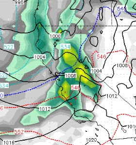
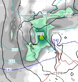
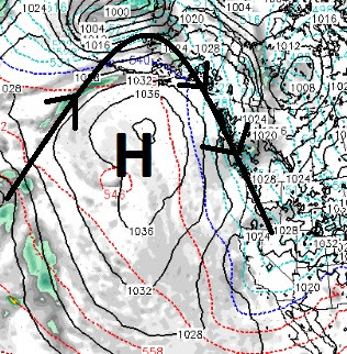
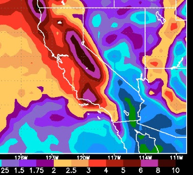
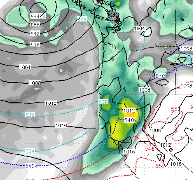
We talked about these two storms in the last post, but I feel it is worth putting out an update as both of these storms are large and packed with moisture. The first storm will show up very early Thursday morning. It will stick around for some 60 hours with heavy to moderate snow fall nearly non-stop for the Sierra. I like the trajectory of this storm to spill over and create havoc in the leeward valleys. We are looking at 3-5 feet or more for the Sierra while the foothills could see 1-3 feet and the valley floor could pick up several inches. This storm will be raging starting Thursday morning and last about 18-24 hours before a short lull and then another strong wave comes in. Here is a look at the forecast for Thursday at 4:00pm: All snow at all elevations for the Tahoe Ski Resorts. The next storm comes in very early the morning of March 7th. The EC weather model has this storm slamming us again, although not as much as the first storm. Here is a look at the forecast for the 7

Tahoe March Miracle?

Image
We have one storm, that has strengthened and is pulling moisture from the Pacific, knocking at our door. Another large spring storm on tap for Thursday, Friday and Saturday. We are tracking a third storm which right now looks big for the following week. All three storms will be all snow for all Tahoe Resort Elevations. Add it all together and do we have the March Miracle? The first storm has picked up moisture and will hit Tahoe tomorrow morning. Right now the EC weather model has this storm hitting the area around 4:00 am tomorrow. Here is a look as the wave of moisture moves right over us, at the noon forecast for tomorrow: This storm will stick around for about 24 hours. I do not see an enormous amount of moisture associated with this storm. For the Carson Range we should see about 6-12 inches of snow, possibly a bit more depending on how much moisture this thing picked up. The next storm is much bigger, but right now, not the biggest of the 3. Still, this storm has an im

As Ridge Slides West, Storm Door to Tahoe Opens

Image
We are liking what we are seeing as we are settling into a classic winter weather pattern. The key of course, is our persistent ridge of high pressure. During the beginning of February, that ridge set up right on the coast and warm mild weather followed it up into Tahoe. As the ridge continues a slow push west, cold air is coming down from the north along with several storm systems. Here is a look at the current conditions, notice the location of the ridge of high pressure, which is much better than the beginning of the month (if you like cold and snow): As the storms follow the Jet Stream up and over the ridge, they then come back down packing cold air. This is a classic "Inside Slider Pattern". Storms come down from the north and even a little from the east and bring cold air and some precipitation. How much is very difficult to forecast. In this pattern, the Carson range picks up more snow than the Sierra. Remember, the Carson Range is located on the eastern side of L

String of Storms from North Start Sunday

Image
As our ridge in the jet has slid west, a small opening of the storm door door is being created. A string of storms are poised to hit our area, each progressively stronger, each pushing that ridge a little further west. What does that mean? Snow, maybe not lots of it, but certainly some snow that could be measured by the foot and not the inch. It also means much cooler weather. We see 2-3 feet of snow coming our way in the next 10 days and possibly more. These storms are mostly coming in from the north so we do not see shadowing, in fact the Carson range could pick up more snow than the Sierra. Here is the timing: Sunday 2/18 Early Thursday 2/22 Late Friday 2/23 Monday 2/26 Notice as the ridge slides a little more west, the storm track begins to come from the northwest as opposed to due north. That means there will be a better moisture tap and thus more precip. Folks, this will be all snow for the Carson range as much colder weather is coming our way starting S

Storm Outlook: None

Well, this coastal ridge of high pressure, which is bringing in unseasonably warm temperatures, looks to be sticking with us, perhaps through the entire month of February. In our last post we talked about some storms knocking it out to sea (where it belongs this time of year), but both the short and medium range models have that ridge locked in right over us. Which means the storms will go around us. We try to bring hope during these dry times, but folks it looks like we are paying the price for 60 feet of snow last year. That is how averages work. Having said that, one model does have a change coming our way toward the end of the first week of March. We will keep an eye on things and report accordingly. In the meantime, enjoy the beautiful weather, it aint going to last forever, that I promise! Stay Tuned ...

When will the Storms Start Again?

Image
Every weather outlet, including the NWS, is talking about warm, dry weather into the foreseeable future. In fact, last week at this time we talked about the very same thing. However, as we all know, the weather will change. We see that change coming late in the first week of February and a larger storm around the 11th - 13th of February. The possibility does exist of a more significant storm coming our way around the 22nd of February. Although high pressure will continue to build in behind these storms, we see a pretty average February in store as several storms will knock that high pressure out to sea and bring snow to the Sierra. In fact the European (most reliable) long range model, which was more accurate in January than it's sister Deterministic model see's this for precip in the first 3 weeks of February: Most of the Sierra picks up 10+ inches of liquid. Because we are getting later in the season, there is a greater shadow effect, but we see the Carson Range in

Two Storms Then Prolonged Dry Period

Image
We have one real storm and another storm that will break up around the time it hits land. After that, a coastal ridge of high pressure will move over us for at least a week and probably more. There will be a disturbance that will move in tonight. As this disturbance moves inland and hits the Sierra, it will break up and probably will amount to 1-3 inches of snow, during the day tomorrow, at best in the Carson Range. The next system looks much better but is still not what we would consider a big Sierra storm. This storm will be colder, snow levels to start at 6,500 feet and drop quickly. However, like last storm, this is a fast moving disturbance which will limit the amount of snow it brings to the Sierra. Here is the forecast for Wednesday afternoon: This thing will be mostly gone by noon on Thursday. It does have some moisture to work with and I look for 8-16 inches of snow for the Carson Range and a bit more for the Sierra Crest. After that, high pressure moves in and camp