Posts

Winter Outlook: Warm Fall Could Give Way to Above Average Winter

Image
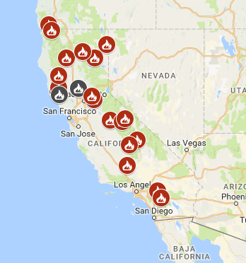
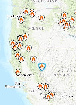
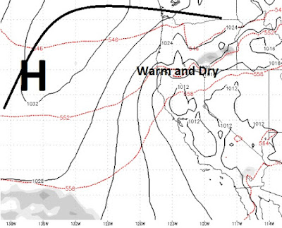
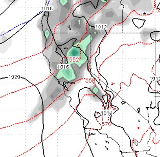
A blocking ridge of high pressure is firmly entrenched off the west coast and is not going anywhere for at least a few weeks. This will continue to bring very mild temperatures and no precipitation. We probably will not see a change in this pattern for around 3 weeks. We still believe, however, that we should be in for an average to slightly above average precipitation total for the winter. We believe that by late December through the spring we are looking at El Nino conditions, albeit a weak to moderate El Nino. We also believe that when the pattern changes, it could be significant. First let's look into why we believe that despite the slow start to winter, we should recover with average to above average precipitation. First of all there is El Nino, here is what we are seeing for the coming months: Although, this is not a strong El Nino, it is still El Nino. Last year we were in a weak La Nina. When the equatorial  Pacific waters started warming we fell into a near

Smoke Relief in Site

As the fires continue to rage across all of California, our winds will shift from the east / southeast and that should provide a couple of days of summer for the leeward valleys of Nevada. We were hoping this materialized and it did. Unfortunately, our prevailing winds come from the west and we will be back in the smoke by late in the week, so enjoy this very short reprieve. It could be the last one for a while. Coming Up: El Nino is headed our way along with diminished sun spot activity. What does it all mean for the upcoming ski season? Stay Tuned ...

The California Idiocy Dilemma

Image
It used to be that if California wanted to ruin itself, it's resources, it's people and it's land, then let them. For many decades we have watched Californians do wrong. Hey, that's their business. Since the left has taken over California, we have watched nearly every decision made, be made based on politics and not on what is right or wrong. The end result is that California is the laughing stock of the world and an example of human idiocy that has not been seen before. Californians are migrating east at an alarming rate, changing the politics of states like Nevada, Arizona, Colorado, Oregon and Washington. Bolstering big government because the government is our only hope to save us from human indecency. Can we classify a new disease; Californiaitis? Oops, sorry for the delay in writing this. You see my office is powered by a mobile solar station that I built a few years ago. But that just died and I lost power. So I had to plug everything back into the grid. You see

California is Burning; No end in sight for Smoke.

Image
California is burning. Regardless of which way the wind changes, our area will continue to be pumped with smoke. This is partially due to a very wet spring, which means lots of tinder by the time the dry season kicks into full gear and decades of forest mismanagement, caving to environmental groups that insist on no logging, but put out all the fires. Eventually, they cannot be put out until they burn themselves out. Here is a look at what is happening right now: Another look from the satellite: I hate to be the bearer of bad news, but I just ran the latest ECWMF, and things are not going to change for at least the next 7-10 days and probably more. There is some indication that possibly a shift to winds coming from the south and east in about 9 days. Mother nature will not be helping, as this is the peak of the dry season with little or no chance for precipitation. Stay Tuned ...

Final Two Storms, Then High Pressure and Warm Weather

Image
We have two fairly weak systems coming in. If you read our last post, nothing has changed. The timing is still right on as one system comes in this afternoon through Monday and a much weaker system will bring in more cold air late Wednesday. After that last system, high pressure moves in off the coast, which will bring much drier and warmer conditions to the area. So if you are impatiently waiting for a little warmth, that will begin next Friday. Between now and then, expect unsettled conditions with below average temperatures. Once the ridge of high pressure moves in, we see an extended dry and warm period for the entire Tahoe region. High Pressure Sets up for Next Weekend When will the storm machine get cranking again? Well, we are pretty late in the year, but we know that winter is usually not over until the middle of June, despite pockets of summer being sprinkled in. Stay Tuned ...

4 Small to Moderate Storms Over the Next 10 Days

Image
We are tracking four storms over the next 10 days. Here is what we are seeing: Tuesday Afternoon 4/10 - This is the smallest of the storms and barely qualifies. However it will give our persistent ridge a swift kick in the you know what. Any precip that does fall below 8,000 feet, will be rain. Late Wednesday 4/11 - Larger storm that will have some valley spill over effect. Snow levels will start at around 7,500 feet and rapidly fall all the way to the valley floor. It will feel like winter around here come Thursday. Sunday Afternoon 4/15 - Temperatures begin to recover Friday and Saturday, then another storm comes down from the north. As the cold front pushes through, Monday and Tuesday will again feel like winter. Wednesday Evening April 18th - Another cold storm from the north. This will push through and temps will plummet again. This should have some valley spill over as well. As cold front comes through, snow levels will drop to about 6,000 feet or possibly even

What a Mess! 11,000 Foot Snow Levels + Heavy Precip = Major Flood Risk

Image
We have an excellent snow pack in the Sierra. Ideally, we would like that to slowly melt away. However, we have a major storm coming in, bringing with it tropical rains that will push snow levels over 10,000 feet for most of the event. If you are one of those people that are scared to death of drought, then you will love this: When we reach April, the rainy season is mostly behind us. Yes, in the past we have seen storms in April, but not like this, not that I can remember. We are talking about 10+ inches of rain for parts of Northern California, 4-6 inches for the Carson Range, 2 inches for the leeward foothills and perhaps an inch in the valley. Snow levels for most of this event will stay above 10,000 feet. Not until the very end will some colder air get forced in and bring snow levels down, but by then most of the rain will have fallen. With all that moisture falling in the mountains melting tons of snow it only has one place to go; DOWN. If you live in a flood prone