Posts

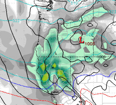
Cold Slider to Produce Cold, Not Much Snow; Pattern Change 2nd Week in March?

Image
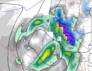
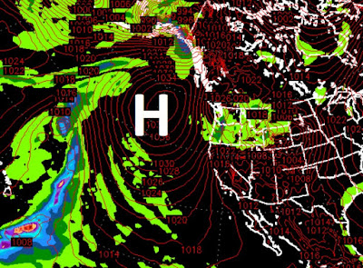
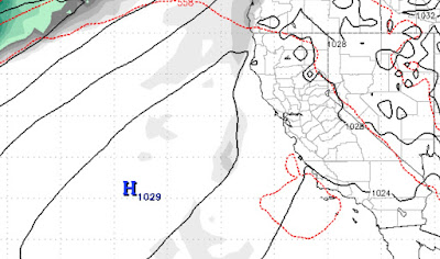
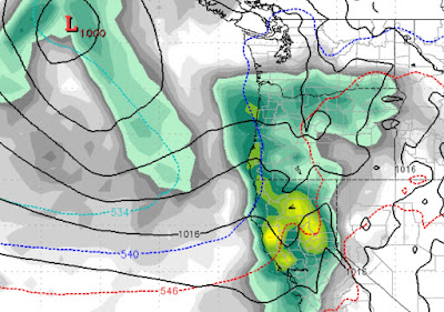
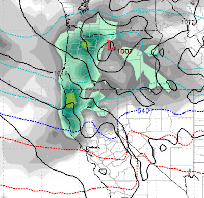
A cold slider will slip down the leeward side of the Sierra and could produce more snow for the Nevada valleys than the Western Crest of the Sierra. I guess at this point we should be happy with any precipitation. We see this storm coming in late Saturday into Sunday. By Monday afternoon temperatures will recover and become seasonal to above average moving forward. We are seeing at least the possibility of a pattern change around the 10th of March as a much larger storm could effect the area: We are still a long way out on this one, but there could be a last ditch effort for winter to reappear in the mountains of Lake Tahoe. Stay Tuned ...

No Major Pattern Changes in Foreseeable Future

Image
TWB is a long range forecasting service. Unfortunately, we have to have something to forecast in order to blog. This is just a reminder to our loyal readers that we are still around, but Ma Nature is not cooperating. We have been in an impudent pattern that brings 4-5 days of mild weather and then a dry cold front drops out of the north and we get cold for a 2-3 days. That is not going to change. Next weekend will bring us yet another cold front from the north. This system has very little moisture associated with it. It will then clear out and we will hit 4-5 days of seasonal to above average temperatures. Here is the culprit. The ridge of high pressure is blocking the west coast and is moving, however slightly, north and south. I glanced at the EC Monthly Control View and it is showing no precipitation for our area for the next 30 days, that is well into March. Of course that could change quite quickly. Ironically, we have no idea what instigates this change, but it happens

Warm Storm, Then High Pressure Brings Indian Summer

Image
In our last post we talked about this storm coming our way. Mt. Rose will be the winner as snow levels could approach 8,000 feet. We expect less than a foot. Snow levels will fall behind the front, but most of the precip will have already come through. This will be a rain event for the leeward valleys. High Pressure will move into place around the middle of next week. With it will come unseasonable warm temperatures. I believe some valley locations could see 60 degrees or even warmer. Here is a look at the ridge as it moves in and dominates our weather: We are seeing no major pattern shift for at least the next 10 days. Stay Tuned ...

Glancing Blows For the Next Week

Image
We have several storms that will give us glancing blows but no major precip as they are directed north. There is a chance of a decent storm in about a week as both GFS and ECMWF models are hinting at a storm for next Monday. After that it looks like ridge city as this storm cycle comes to an end. We will post a little later on this week when we get a clearer picture of what is going to happen. Stay Tuned ...

Storms Update and Timing

Image
We have several storms poised to hit or hitting Tahoe right now. In addition, the ECMWF model is forecasting another major storm around the 22nd of this month. The big event will be Thursday and will last throughout much of the day. This will be a 12-18 hour event as this storm will move through Tahoe rather quickly. Thursday @ 10:00 am Thursday @ 4:00 pm Thursday @ 10:00pm Snow Totals: Sierra and Carson Range: 18-40 inches by Friday afternoon. Leeward foothills: 6-12 inches by Friday afternoon Leeward Valleys: 2-6 inches by Friday afternoon In somwhat of a new development, the latest model run of the ECMWF has a major storm impacting Tahoe on the 22nd and 23rd of this month: If this storm holds together it will be much warmer and much wetter. The GFS model is starting to show some signs of this happening as well. Here is a look at the precip forecast for the next 10 days: Stay Tuned ...

Expect Snowy, Windy Week, No Matter Where You Are

Image
We have 3 storms that will have a major impact on Tahoe weather coming in the next week. The mid-week storm is a fairly rare type for Tahoe. However, even at this late date, the models are not in agreement on the amount of precip headed our way. The EC model is much more bullish on precip for the first two storms and the GFS has forecast more precip for storm three. Storm Timing: Late Monday, January 13th Expect a major wind storm in the Sierra starting at noon Monday. The precip should roll in very late on Monday night and should last on/off through most of Tuesday. We expect 6 inches of snow for most of the Sierra including the Carson range out of this first storm. There is a big birthday celebration on Tuesday, that could be blown out, however the winds should begin to die down by noon on Tuesday so you never know. Late Wednesday, January 15th Ok, this is the granddaddy of them all, and I am not talking about the Rose Bowl. The NWS has called this storm the biggest of the

Pattern Change is Here; 3 Storms in Next 10 Days

Image
The much anticipated pattern change that we have been talking about has finally arrived. There are 3 storms that should come into our area and deliver some much needed, fresh snow. Each storm will get progressively stronger. For now, conditions are very firm and some rocks are beginning to peek through, I read a very interesting article over on Unofficial Rose as very dangerous conditions exist in the Mt. Rose Chutes, check out the picture posted there after a huge storm! After several week waves roll in from the north and deliver a few inches of snow over the weekend, the first real storm should roll in here Monday night (1/13): This is the weakest of the storms. The next storm, which is much stronger should come in next Wednesday after noon (1/15) and should last through at least Friday morning: Next, the following Sunday (1/19),  see's the 3rd storm in the bunch roll in: All told these three storms should produce significant precip and should be cold enough t