Posts

Hope You Enjoyed The Nice Weather

Image
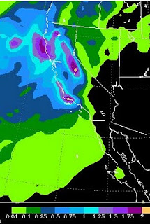
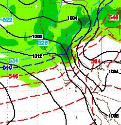
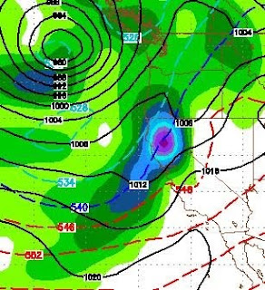
Mt. Rose closed too early this year. A large storm is headed our way for this week and our weather will be stormy for about another week or more. I talked about this pattern in my last two posts and it is a typical spring pattern in an El Nino year. Here is a quick look at Tuesday morning. This should system should produce 1.5 to 3 inches of liquid precip. Translated that will be 1-3 feet of snow for the Sierra: I apologize for not posting this earlier, but I have been out of town. For those of you looking forward to more hospitable golf weather, there are indications that May might come in like a lamb after this very turbulent April. However, the real stable weather will not show up until well into June I expect.

Decent Sized Storm, On Our Doorstep

Image
The storm I talked about last weekend has arrived and is knocking on the door. It is currently located about 500 miles west of Oregon. It will continue to move east until it hits the coast and then head south down the coast until it swings inland Sunday into Monday. The models are not totally in agreement with this system. There is a chance it could split with the bulk of the energy going down to the south central Sierra. However I am going to go out on a limb and predict this storm holds together and comes into the Sierra somewhere between Tahoe and Mammoth. This is not a huge storm but will produce some pretty decent precipitation in the Sierra just in time for Nevada spring break. The Accumodel shows about 1-2 inches of liquid precip for the Tahoe Sierra, with some areas around Mammoth receiving 2+ inches: I believe the storm will move slightly north and bring about 1-2 feet of precip to the High Sierra with around a foot for Mt. Rose by late Monday. Here is what the GFS weather

Midweek Clearing - Next Weekend Another Storm

Image
Shortwave city. Imagine a giant up in BC throwing snowballs down the coast and hitting us. That is what is taking place. A huge area of low pressure is firing off short waves of cold air. They travel down the coast, suck up the warm ocean water, hit the Sierra, rise, condense and dump. Some of the best skiing/riding conditions in the last 3 years as April comes in like a lion. I may well have underestimated our current short wave when I guessed 18-24 inches at Rose. I was up there around noon. Here is a picture of my daughter and what the weather looked like: She is  a good sport as the wind was howling around 50+ mph and snowing heavily. It took about 1 hour for conditions to turn to all powder. However, very slow lift and at the top it was a little hairy. This is supposed to continue until about 3:00 tomorrow afternoon. After that the weather looks nice around mid week with light winds and much warmer temps. But don't get used to that because it aint going to last. Next we

Mountain Snow Well Into Next Week

Image
A very large storm system that is centered well north of us continues to fire short wave patterns our way. The latest storm dumped nearly 30 inches at the top of Mt. Rose ski area. There is more coming. Tomorrow evening is shaping up for another bout of cold and snow, especially in the mountains. Should make for a great Saturday for the general public to get out. Here is a look at yesterday atop the mountain. The snow in the Mt. Rose Chutes ranged from 24 to perhaps 50 inches deep. A lot of snow blows in there and it was one of the better days of the year. This is Scott executing a heal turn and getting a face full: The steeps of Mt. Rose. I talked to the head avalanche forecaster for all of Tahoe and he claims that the chutes of Mt. Rose slide more frequently and violently than any other ski area in Tahoe. If you look closely, this next picture will show you why: The next short wave arrives Sunday. This is a larger system that could bring significant snow to the mountains and

Massive Cold Front To Dominate Our Weather - Dangerous Wind Gusts Likely

Image
There is a very large storm well north of us that will be sending some very cold air our way today, tomorrow and Wednesday. Along with that cold air, we could see our windiest conditions in a number of years, especially on the leeward side of the Sierra in the foothills. Places like Galena Forest and Arrow Creek. Accompanying this cold front is a pretty nice sized winter snow storm. It will spill over and snow all the way to the valley floor, heavy at times after the cold front comes through late Tuesday. Take a look at Tuesday afternoon: This snow event, which should bring 2-3 feet to the High Sierra, will last about 36 hours in the mountains. Here is a look at liquid precipitation levels: The western side of the Northern Sierra around Lake Tahoe could receive as much as 4 inches of liquid precip. Mt. Rose could get 18-24 inches of nice light powder from this event. Wednesday morning could be quite a treat for those of you who can make it up the mountain. Dangerous Winds Com

PNA Turning Positive, Weather Should Turn Nice

Image
The NOAA PNA is forecasted to go strong positive which should mean strong ridging off the coast and very nice weather for our area. Have a look: High Pressure will dominate our weather through next weekend. A weak system will come through tonight (Saturday) and another on Wednesday. High Pressure will setup to our south and west which will act as a blocking force and push the storms north. Expect highs in the 60's starting around next Thursday. For now it looks like a beautiful next weekend. Get those sticks (golf) out and start swinging as spring is here. Having said all that, we still have a moderate El Nino. Our pattern is going shift, but we have at least a couple more shifts back down the scale to prolonged stormy weather coming. There is an excellent base of snow out there. This is a great time of year to ride or ski in the morning and golf in the afternoon.

Stormy Week Ahead. Big Storms For Next Week?

Image
We have a series of small storms that will affect our weather over the course of the next week, starting on Tuesday. Another band comes through on Wednesday, Friday, Saturday and Sunday. We will then get a little reprieve before a much larger storm comes calling. All week looks excellent for riding and skiing conditions. On or around March 10, GFS has this storm slamming us. A similar storm could also hit us 3 days later: El Nino has weakened, but is still firmly in control of our weather. I would expect this to be a very turbulent spring with summer arriving late. As these storms approach from the Gulf of AK, I will keep an eye on them and report back to you!