Posts

Showing posts from November, 2020

Storm Machine to Shutdown; Ski Areas May Also

Image
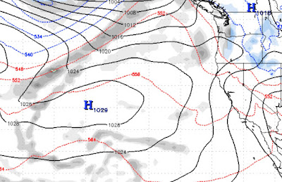
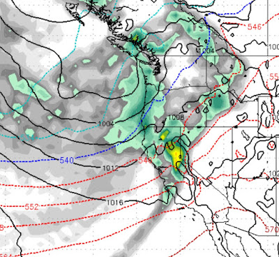
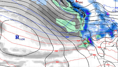
 We are seeing a massive blocking ridge of high pressure setting up just off the West Coast: This ridge of high pressure is going to settle in, push all storms well north of Tahoe and stay there through at least the first week in December. Both the GFS and EC weather models are in agreement, which means the likelihood of this happening is high. Here is a wider look as the ridge in the jet stream sets up: This is a classic La Nina pattern. Having said that, the models have been really struggling with anything more than a few days out this year, so hope is not completely lost. Currently the long range models are showing a sign of the ridge breaking down around the 10th of December. All we can do between now and then is hope that Ma Nature flexes her ample muscles and returns us to the snow. Similar to the weather shutting down, rumor has it that Nevada may be shutting down as well. We certainly hope not as checking the hospital data in both Washoe and Clark counties we are seeing the fol

Storms are Stacking Up

Image
 We continue to see a very active weather pattern for the next several weeks. The models have consolidated. They are backing off on the precip amounts but not by much. 11/17 - 11:00 PM This first storm now finds the EC model a bit more bullish. It is born in the north, is a warmer storm that will pull up sub-tropical moisture from the south. The redlines and blue lines signify the cold front. The further north the redlines are, the warmer the storm. We are guessing around 6,500 to 7,000 feet. So this will be all snow for Mt. Rose. Our best guess is around 12-18 inches. 11/24 A series of smaller events will keep our weather unstable. Then on the 24th or thereabouts, the next storm will arrive. This is a smaller storm, but we have seen this pattern before. We believe this storm is wolf in sheep's clothing and could produce another foot of snow. The final storm we are tracking will arrive around the 28th. This is a much larger storm. We still do not have a clear picture of what this w

Storms Update; Three Storms in the next 2 Weeks

Image
This last storm was an overachiever and ushered in a major pattern change. Fairly typical for this area; a single storm, in one day, changes our weather from summer to winter for several months. We are just over a month away from the Winter Solstice and winter has finally arrived. If you read our last post, we were tracking 3 storms. The models are consolidating and our confidence of a major winter event, is now very high. The only real change is the timing. It would appear that everything will arrive about a day sooner than expected. First, here is the GFS precip forecast for the next 2 weeks: The Tahoe area looks very much like 8-12 inches of liquid precip in the next 2 weeks. The GFS is more bullish than the EC, but the EC is coming around. These storms will be warmer and will produce a better base than what we saw this weekend. We can expect the next storm to show up late Friday November 13th. That will be a fast moving storm. Close on it's heels is another storm for the 16th.

Storms Take Aim at Tahoe

Image
 As we suspected, a slight change in the Jet and we could see winter with snow in our mountains, sooner rather than later. We are beginning to see that change now and if you believe the GFS weather model,  a series of storms are poised to hit our area starting around 14th of this month. The key is the high pressure ridge in the jet is now forecast to move quite a bit to the west, that should open the storm door. We are currently tracking 3 storms, each getting progressively more intense: 11/14/2020 Notice how far west the ridge of high pressure has moved. That opens a wide storm door. What we are not seeing is a big moisture tap to the south ... not yet. 11/18/2020 Our Ridge stays to the west, keeping the storm door open. La Nina storms can be much larger and despite these being early season storms, they are quite powerful. 11/20/2020 This storm looks to be the king. In true La Nina fashion, it will have the greatest effect on Northern California and the Pacific NW. Notice the moisture

Tahoe Winter 20-21 Outlook; Winter Starts Friday

Image
Before we predict what you will see in the 2020, 2021 winter season, let's get one thing clear; Mother Nature is in charge of this ship. We see some patterns that could repeat and we make our predictions based on those historical patterns. We are already beginning to see a pattern shift. In simple terms, we are moving into our wet season. That is good news because this was one of the driest summer/falls in recent memories. Below is a precip chart for this winter season provided by NOAA. The white represents average precip. We agree for the most part with this chart. Tahoe is right on the border of drier than average. Southern California will continue to see dry conditions and the drought mongers will have something to talk about after several years of above average precip. We are looking at Tahoe getting below normal precip. Possibly quite a bit below normal. Those averages have stayed consistent for many decades and quite simply we are due for another dry year. Couple that with La