Posts

Showing posts from February, 2023

More Storms, No Big Warm Up

Image
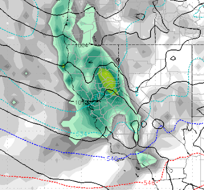
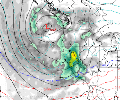
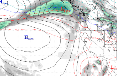
I feel like this is a retraction. In our last post we talked about and showed a forecast from both the GFS and EC weather models that showed the possibility that spring may actually arrive in the form of a big warmup. Those models and all others have done a complete about face. Instead we are looking at more storms that could last into the foreseeable future. Let's start with next weekend's storm. Right now a weak area of low pressure is going to camp right off the west coast and bring multiple waves of precipitation to the area: This storm will begin to impact Tahoe on Saturday (3/4) and will stick around until it joins forces with a storm from the south on the following Thursday (3/9). An already saturated Southern California is about to get hit with another large storm. This will bring large amounts of moisture to the entire state of California. Then, right on its heels things get really interesting. We have 3 areas of low pressure that should connect and form an AR event on

Storms to Continue for Another Week, Then Big Warm Up

Image
The current storm cycle will continue on and off  (mostly on), through next Saturday (3/4), then it appears our pattern will change to dry and possibly warm. Both our favorite models are predicting a huge warm up starting around the 8th of March. We could actually go from lows in the single digits to highs in the 70's. First, we have a series of storms that are going to continue for the next week. Here is a look at what we are seeing: Sunday 2/26 @ 4:00pm Monday 2/27 @ 4:00 pm Wednesday 3/1 @ 4am Saturday 3/4 @6:00pm So the pattern stays active until the 5th of March as the storms slowly move away and high pressure begins to take over. Take a look at the forecast for the 9th of March: That is some very warm air all the way up into BC. That trough of Low Pressure is going to bring up some sub-tropical air. Of course with the huge snowpack, that could cause a very quick melt off, so we will have to keep an eye on that. Here is the forecasted precip totals for the next week: Looks lik

Cold Storms Begin Their March Through Tahoe

Image
Yesterday's cold front was just the beginning of a series of storms poised to hit the Tahoe Area for around the next week. We are seeing a rather significant Rain Shadow associated with these storms. Put another way, the Western Sierra will receive much more snow than the Eastern Sierra around Tahoe. The Central Sierra will be picking up a ton of moisture which will be all snow. For Tahoe, the best chance for significant snows come early Friday (2/24) and the following Monday (2/27). Again we are seeing a Sierra Shadowing effect for the eastern Sierra. Here is a look at late Monday: We expect snow on and off through Wednesday (3/1). Here is a look at the precip forecast. Notice the difference between the Western and Eastern Sierra around Lake Tahoe: By the time this storm cycle ends, this will still be a significant precip event, just more so for the Central Sierra. Obviously, this brings very beneficial rains for most of California as their reservoirs continue to fill up.  This wi

Major Pattern Shift in About a Week

Image
The current pattern which is marked by weak cold fronts dropping down and leaving us with a few inches of snow and very cold weather is going to change back to a very stormy pattern in about a week.  The first step is a storm to our north (2/21) that will knock our ridge of high pressure considerably further west. That will open the storm door. Next, a series of storms will come into our area getting progressively stronger, notice the ridge way out at sea: Wednesday (2/22) Friday (2/24) Monday (2/27) Wednesday (3/1) This pattern looks similar to late December and if it holds, March comes in like a lion. Here is the forecast total liquid precip for the week starting February 21st: If you are wondering if you are reading that correctly, yes it says 10-12 inches of liquid precip which could translate into 8-15 feet of snow for most of Tahoe. As has been the case this winter, these will be cold storms and as of now it looks like this will be all snow for all Tahoe Resorts and quite a bit o

Winter Will Continue to Hold On

Image
If it seems like our temperatures have been below average since October, that is because for the most part they have, with few exceptions. That is not going to change anytime soon and we are tracking what could be another major snow event in about 12 days. First, we have several weak, cold systems heading our way, starting tonight (2/10): Temperatures will quickly recover until the next cold front comes in on Tuesday (2/14). Nothing very exciting about this, just a lot of cold air coming down the Eastern Sierra. Temperatures will remain quite cool until about the 21st. Then it appears we have what could be a major pattern change, as a very large and wet storm will shove our ridge of high pressure out in the Pacific and could bring a series of precipitation events to Tahoe. Here is the forecast for late on the 22nd: A lot can change between now and then, but our two favorite weather models are showing this. Stay Tuned ...

Tahoe to get Another Blast on Sunday

Image
Another storm is spinning up as I write this. That storm will deliver moderate snowfall to the mountains and a decent amount of rain to the valleys.  Here is the forecast for Sunday morning. This storm should last through the day and into the evening hours. The heaviest snow will be on the West side of Lake Tahoe: This will be a fast moving storm but has plenty of moisture to work with. Here is the precipitation amount forecast: We are looking at 1-2 feet for Mt. Rose and 2+ feet West of Lake Tahoe above 7,500 feet. The snow level for this system looks to be right at Lake Level. Looking past this storm we will warm up to near average temperatures. There may be a small disturbance around the 11th of February. Stay Tuned ...