Posts

Showing posts from 2010

Storm Update

Image
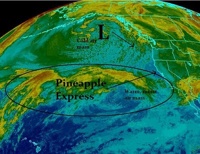
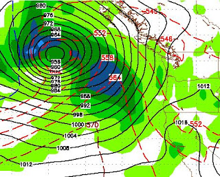
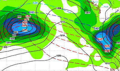
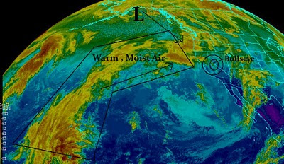
Strong Storm Hold Together The storm I talked about for the 30th is coming a day or two early. Of course I talked about this before Christmas, so I am pleased that things have held together. This is shaping up to be a big storm with several feet for the Tahoe and surrounding areas. Tuesday night and Wednesday morning could be an all out blizzard on top of the mountain. A very cold, large area of Low Pressure is moving out of the Gulf (of Alaska) and down the coast. A huge moisture plume that stretches beyond Hawaii will collide with this arctic air mass. The storm will tap into the moisture and send it right over the Sierra. This is similar to another Pineapple express event. Unfortunately, our cold Low Pressure system is going to make shore in Oregon and move out of the area relatively fast. The entire event will be over by the end of Wednesday. Behind the low is some very cold air. Our temps will plummet, the conditions on the mountain should be near perfect for the remainder of th
Let It Snow

Image
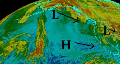
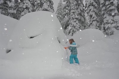
The above image is a girl, this week, trying to dig out her car at Mammoth, with what appears to be an ice scraper. A good friend sent me this image and it gives you an idea of just how much snow has fallen in the Sierra. This picture could play out anywhere from the Central to Northern Sierra as snow could be measured accurately in yards! Weather Moving Forward a bit Sketchy What will the weather be like moving forward? There are currently two schools. The first school is the NWS and the local meteorologists. They believe that things are going to eventually wind down and we will return to some normalcy. The storms I have been warning about around Christmas and New Years are not of particular concern right now. They believe that the pineapple express has moved significantly south and will eventually move out of the area. Take a look at the satellite, which appears to support their argument: The other school is the weather models, NOAA and Myself. There is a very large storm fo

Storms May Continue Through Year

Image
Checking the latest GFS run we are looking a the possibility that the storms may continue through the end of the year. Our best chance for a slight break will be Monday night through Tuesday night before another wave, from this same system, blasts us on Wednesday. We will get another break on Thursday and Christmas Eve. Then on Christmas day another storm sets up to our west. Here is a look at 10:00am on Christmas day: This storm will dump more snow in the Tahoe Sierra starting late on Christmas day and lasting through December 26th. Next, after a short break, a much larger storm sets up on the 29th of December and lasts into the New Year. Here is a look at the morning of December 29th: Stay tuned ...

Storm Totals Very Impressive

Image
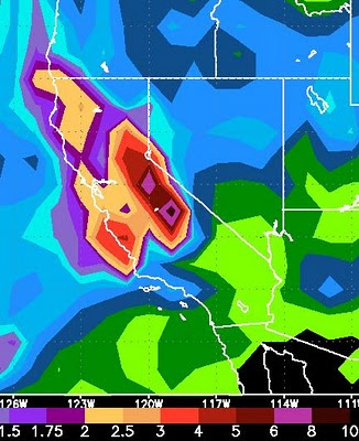
Where Are The Drought Mongers ? Has anybody heard if the drought is officially over? Remember my first blog of the season? In that column I warned people not to believe the La Nina hype. I had been hearing that because of La Nina we will have very little snow this winter. Check it out: First Blog This Season . Storm Update Anyway, on to the business at hand. The big boys are still arguing over the area that gets pummeled the hardest. I say who cares? Almost the entire state of California is going to get drenched by this series of storms known as the Pineapple Express. The storms will not stop coming until next Wednesday. The first in the series is already here. First, let's take a look at the latest satellite, notice that the line has moved north. I think that it is likely that the southern part of Lake Tahoe is the bullseye: Next, let's look at what the weather models are predicting for precipitation through next Wednesday:   Finally let's look at the impact the

Get Ready For The Pineapple Express

Image
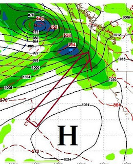
Current Storms (Friday - Tuesday) Conditions are just right for a major weather event for the entire west coast. Here is the latest satellite imagery: The models are still all over the place as to exactly the area of the Sierra that gets hit the hardest. The potential for flooding is very real, as this is a very warm storm. Estimates are ranging from 7,000 - 8,000 feet as the snow level. I believe 7,000 is pretty accurate for the Tahoe area. I am also sticking with yesterday's post that the brunt of the storm will hit in the Central Sierra just to the south of Lake Tahoe. The folks in Mammoth should brace for an amazing week of weather starting tomorrow. That is not to say that Tahoe is off the hook. Right now I believe the bulls eye is just south. The Tahoe Sierra is going to see a tremendous amount of snow. Check yesterday's post to get an idea of how much and when. Coming Storms (12/26 - 12/30) Looking ahead, we will get a slight break, however a similar pattern l

You Aint Seen Nothin Yet

Image
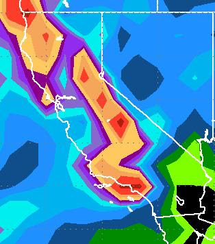
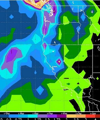
Mt. Rose picked up close to 2 feet of fresh snow on Tuesday. If you think that was good wait until this weekend. All the elements are coming together for a dump that should last from Friday through Tuesday and could bring as much as .... dare I say it?? ... 6-14 additional feet of snow over the Sierra Crest. In my last post I showed you a chart of why I am (everybody else has hopped on the bandwagon, where were they 2 weeks ago?) expecting heavy snow. Not much has changed, the cold low pressure system is making it's way down the coast from the Gulf of Alaska. It is already starting to tap into sub-tropical, warm, moist air. This is a lethal connection as this storm will form, rise and dump over the entire Sierra, all of California, and the western Nevada valleys. The following chart shows just what we can expect by Tuesday night: In the Central Sierra, the GFS weather model is forecasting over 10 inches of liquid precipitation. Most of Tahoe is in the 3-8 inch range and the Le

Big Changes On The Way, Starting Tonight, Lasting Through Christmas??

Image
There are major changes on the way, starting with a weak storm coming through the area tonight and hitting the Sierra with decent snowfall all day tomorrow. Expect 1-2 feet of snow over the Sierra Crest and 6-12 inches of fresh snow at Mt. Rose by Wednesday. The winds will really start to kick up tonight. A major storm, that I have been tracking for 2 weeks, is poised to slam the area late this week and into the weekend. Some model forecasts are looking at 4 inches of liquid precip for the Tahoe Sierra with snow levels between 6,000 and 7,000 feet. That could translate into 2-5 feet of snow. This storm is a ways off and I will update precip totals for the week, here is what we are looking at right now: This is through next Tuesday. GFS is predicting this for 4:00 next Saturday: Interestingly enough, Southern California is going to see a large amount of precip over the next week with some very good surf. Should be tube city  starting next Saturday and lasting about 4 days. So ge

Warm Weather Continues, But Changes Coming

Image
Typical Tahoe The Jet Stream remains well north of Tahoe which means mild weather with minor interruptions when smaller, weaker storms come through the Lake Tahoe area and leave 6-12 inches of snow behind, followed by more mild weather. That will continue with snow above 7,500 feet today and tonight, then mild Thursday followed by another short wave Friday. I played 9 holes of golf late yesterday afternoon, in shorts pants and short sleeves. Today, with early release, Scott and I will head up the mountain and tear it up for a few hours. Mid to Upper 60's For Valley This Weekend A large, warm ridge of high pressure moves in for this weekend through the beginning of next week. That will bring above average temperatures to the entire region with highs in the 50's in the mountains and 60's in the valleys. We may even be able to squeak out a 70 if we are lucky. Look for the slide side parking lot to be filled with tailgaters this weekend. Extremely Wet Pattern Starts Up

Warm, Wet Storm Coming Our Way ... Storms Start Up Again In 10 Days?

Image
The weather models are in alignment. A fairly weak, warm, moist air mass will move into the Tahoe Basin over the next several days and drop around a foot of snow above 7500 feet. Looking forward, the warm air will stay in our area for at least another week. Looking way ahead, GFS has a fairly significant storm coming our way in about 10 days. This storm could bring significant mountain snow to the Tahoe area. Take a look: The bad news is that this storm is 10 days away and much can change. The good news is, that this storm is the first in a series of very large storms that could affect the area. Take a look at the GFS forecast for two weeks out: The really good news is that the PNA seems to be in agreement with GFS and has us moving into a stormy pattern that could exceed what we have seen over the last few weeks: Remember as the PNA goes negative, our storms increase! Keep your fingers crossed and stay tuned ...

Storm For Tomorrow Update

Image
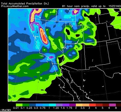
The storm for tomorrow will reach the Sierra by late morning and should dump about another foot or so of snow on the High Sierra with lesser amounts at lake level (3-6 inches). Mt. Rose should receive between 6-12 inches to cover up some of those bare spots. The NWS is talking about a chance for 1/4 inch of liquid precip in some parts of the leeward valley's. That means this storm will likely have no affect on Reno and Carson City. However, this will affect driving over the mountain passes, but everything should be cleared out by Sunday afternoon and travel should be pretty good. For the powder hounds out there, Sunday morning may be the best time to hit the resorts as the storm should have a greater affect late Saturday afternoon into Saturday evening. Here is a quick peak at total, liquid precip for the storm: Looking ahead, EC has another storm coming in next weekend that I will track. For next week, a few short waves may affect the area, but otherwise dry conditions will

Weekend Storm Update

Image
I will rarely post current conditions, but the following map shows what is going on now and what we can expect for this weekend: Right Now Currently there is a very deep low pressure system moving inland through the state of Oregon. This low is going to cause havoc through the central and northern Rockie Mountains with blizzard warnings posted for Salt Lake City and many other areas of Idaho, Utah and Montana. Behind the front is a short wave of precipitation with very cold air. That has already begun to dump very heavy snow in the Sierra and will spill over and cause near white out conditions in Reno, especially west of 395. Be aware, this should occur around 9-11am, so you may want to be off the roads! Thursday and Friday The high pressure system off the California coast will be in control and bring rapidly clearing skies. However, the cold air will be trapped in the valley and this will result in deep temperature inversions. Expect the higher elevations to be much warmer as

Strong, Cold Inside Slider for Tuesday

Image
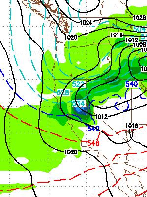
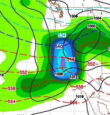
More heavy snow coming to the Sierra tonight through Tuesday when an inside slider drops down from Oregon. The models are in agreement that the Sierra will pick up an additional 1-2 feet of snow. The NWS service has posted winter storm warnings for the entire Lake Tahoe Area. With this storm comes a very cold, Arctic air mass that should bring some of the coldest temps we have seen in quite some time to the area. Especially the valley floors. The cold air will be trapped by the sourrounding mountains as a high pressure ridge moves in for Wednesday-Friday. This will cause temperature inversions. The lowest parts of the valley will see below zero temperatures on Wednesday night. Here is a GFS look for Tuesday late morning: It is my understanding that the good folks up at Mt. Rose are working very hard to open the NW lift in time for Thanksgiving. With the new snow on the way through Tuesday, I am guessing that Rose will be open top to bottom on the Rose side for Thanksgiving, so ge

Quick Storm Update

Image
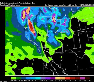
This storm continues to pound the region and will continue, on and off, through Wednesday morning. A very strong Arctic cold front will move into the area Tuesday through Wednesday and temps will plummet. We are talking below zero temps in the valleys for Wednesday night. Here is an udpated precip amount map: Most of the Sierra is going to pick up around 4-5 inches of liquid precip by the time this is over. That translates to 30-80 inches of snow with the central Sierra Crest getting the most. A very strong temperature inversion moves in for Thursday and Friday with mountain warming and very cold temps in the valleys. This is ahead of what looks like another decent system moving in for next weekend (See last post). Stay Tuned ...

Storm Strengthens

Image
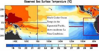
Storm Update In what is typical La Nina fashion, the storm I have been discussing for the last couple of weeks has strengthened and is heading to Tahoe. This is an extremely deep low pressure system, especially for this early in the year. It is also a very cold storm. This storm formed in the Bering Sea, dropped into the Gulf of Alaska, and is now heading down the West Coast. As it approaches our area, it will tap into additional Pacific Moisture. It will rise into the Sierra, Condense and dump! There are several waves of snow associated with this massive storm. These waves will represent very heavy snow. The first wave should start up around 3:00am on Saturday and last for about 12 hours. Then we will get a brief reprieve before another short wave shows up around 10:00pm on Saturday Night and should last through Sunday morning. From there, we can expect light to moderate snow to last through Monday morning. I will stay with my snow total amounts of 12 days ago, 2-4 feet in the Sierr

Enjoy The Nice Weather, It is coming To an End

Image
The weather is going to be beautiful for the next 4-5 days. Then what is shaping up will be a decent storm toward the end of next weekend. In my last post, I talked about a larger storm coming in around the 22nd. Both the GFS and EC weather models are now talking about this storm more agressively. When the models align like this, they are normally very accurate. Before I was just overly optimistic about this system, I am now cautiously optimistic as some of the big long range forecasters are now also talking about this. How much and when remain questions, but suffice it to say, this should be the seasons first large storm. The EC weather model has about 2.5-3.0 inches of liquid precip blanketing all of the Lake Tahoe area. The system will have some very cold air associated with it so snow levels should be fairly low, starting at 7,500 and moving down as the storm hits. Here is what EC is saying for total precip through the 23rd: This should translate into 2-4 feet of snow for the mo

Stable Weather for 5-8 Days and Then Return to Stormy Pattern

Image
Inside slider slid right down the eastern Sierra and is bringing more cold air with it. You were warned. Tonight should be very cold. A giant ridge of high pressue will move into our area tomorrow and will not be moved until Monday or Tuesday of next week. This will bring a gradual warming trend with highs in the upper 50's by early next week. Once the ridge is moved out, indications are that we will return to another stormy pattern. GFS is calling for a large storm to slam our area on the 22nd of November, here is a look: I am pretty sure that I am the only idiot who is trying to predict a big storm 12 days down the road, but hey, I am not paid for this so take this with a grain of salt. In addition, I am not predicting this, the GFS weather model is. Also, the EC weather model has a large storm forming around the same time and coming into our area, although the EC is not as aggressive as GFS. One last reason why I brought up this storm, the PNA is going negative right arou

Today's Storm Strengthens, Wednesdays Get Colder

A large area of precipitation will move further west than I anticipated with my last post. This is really good news as we can expect 1-3 feet of snow at Mt. Rose by Tuesday Morning. Wednesday's storm, however, is losing moisture and gaining really cold air. The models are pretty much in agreement that we will not get a major precip event, but look for the bitter cold air to come in that I talked about in my last post. Amazing how fast the weather can change this time of year, so let's not count out Wednesday quite yet. After Wednesday we will become dry and temps will rebound, but only slightly. Looking way ahead, I see a stormy unstable period for 10 days, starting next Sunday. Stay Tuned ...

Three Storms, Each Getting Progressively Stronger

Image
Two Storms This Weekend I am tracking 3 storms right now that should play a significant role on our weather and more importantly what happens up in the mountains. The first storm is coming in Saturday night. This is a splitter and does not have a ton of moisture associated with it. However, right behind that storm, for Sunday night a much larger storm moves into our area that should bring some reasonable amounts of snow above 8,000 feet. Here is a look at the total precipitation through Monday afternoon: If these systems hold together, the western Sierra around Tahoe could pick up 1-2 feet of snow, with about half that for the eastern shore (Mt. Rose). Much Cooler Next Week Starting Monday and lasting for at least a week our temperatures will be much cooler, with highs in the upper 40's for the valley. The High Sierra will see below zero readings in some spots. This will bring snow levels down just in time for what appears to be a much larger storm that should track right t

Here She Comes

Image
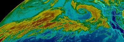
Storm Still North, but Moisture Coming Our Way With Direct Hit The giant storm that I have been talking about for the last 10 days, is moving across the Pacific. The blocking high has weakened and it looks like we will be hit pretty hard by this storm in the way of precip. Snow levels, however, will be very high. Here is what the storm and moisture tail look like from space, notice the moisture tail wrapping around about 40% of the planet: Here is what we can expect Sunday morning: Here is a total moisture forecast by Monday night: Areas north and west of Lake Tahoe, could be looking at 3-5 inches of liquid precip. As far as Reno and Carson City, the models are not in agreement. However two models are talking about heavy rains on Sunday, especially in the western foothills. This is just the beginning. The models are showing a series of very large storms heading into the area. We will get a few days off next week, but come Thursday another large storm is heading our way.

Massive Storm Will Affect Our Weather

Image
The remnants of Typhoon Megi are going to get caught up in the westerly flow, cross the Pacific Ocean and Slam the coast of Washington State. This is a very large storm packing extremely high winds and lots of moisture. Here is a look at the storm as it approaches the Pacific Northwest on Saturday evening: If you have not seen these weather maps that I post, you can make out the Northern West Coast of the US on the right side of the image. Northern California is in the lower right corner. This storm will impact our weather this weekend. The NWS is calling for 1.5-3.0 inches of rain along the north shore of Lake Tahoe. Some of this rain will spill into the valley adding to our already record amount for October. Here is the GFS precipitation forecast. GFS is calling for lesser amounts in our area. The NWS gets there information mostly from the EC model: GFS has about 1/2 to 3/4 of inch of rain for Lake Tahoe and perhaps a 1/4 inch for Reno. Any snow associated with this very war

Storm For Next Weekend Update

Image
In my last post I talked about a rather large storm that the GFS weather model says will tap into sub-tropical moisture and produce copious amounts of precipitation. The weather models are starting to agree that a strong area of high pressure will settle into our south and west. This area of high pressure will probably push this large storm north of our area, giving us a near miss. Here is a look for next Sunday, notice the huge area of high pressure off the Southern California coast which is blocking the storm from coming into our area and pushing it well to our north: A lot can change in the coming week and the GFS model originally had this storm hitting our area. It is a large storm and with our already swollen rivers and saturated soil it might be best for this one to move north. These sub-tropical storms are usually very warm. Snow levels will start around 9,000 feet or higher. With last nights rain, Reno broke its all time record for total precipitation in the month of Octo

Winter Weather on the Way

Image
A system up in the Gulf of Alaska will split and send a weak low our way for Sunday and Monday. There is some decent moisture associated with this system. The GFS model has it hitting us pretty square and dumping some mountain snow above 8,000 feet on Sunday night. This system does have the potential of sending rain into the valleys Sunday night into Monday, with the possibility of Thunderstorms on Sunday afternoon. If you are planning on traveling over a Sierra pass south of I80, you may have some trouble Sunday night into Monday.  This is impressive enough for the NWS to post a warning. Cooler weather for next week improving by midweek ahead of the next system. The next system comes in on the 23rd and is much more impressive. This is a long way off, but if this holds together, we will have a 2 day snow event in the mountains that should register some decent accumulations. Below is what GFS thinks will happen the night October 23rd (Saturday).     There is another decent system

Dry Weather For The Next Couple of Weeks

Let's count our blessings for the stormy weather of last week. Parts of the foothills west of Reno received nearly 4 inches of rain. The higher elevations received over 2 feet of snow. That is free water. However, that snow will probably not stick around as our weather will be for the most part dry with seasonal temperatures. The possible exception to this is next Sunday into Monday. A system will approach from our north. The models have this system pushing down and giving us an opportunity for valley rain and mountain snow. That is a long way off. I will update if this system turns into anything substantial. There is a very strong MJO in the Indian ocean. That should move east out into the Western Pacific. What does this mean? There is a chance for a major storm brewing up in about 2-3 weeks as the MJO tracks east. MJO, which st ands for Madden–Julian oscillation, can be used as a predictor for our weather. A very similar pattern to what we are seeing now took place in 1996, alb

When Will The Party End?

Image
At Least Two More Weeks of Near Perfect Weather For winter enthusiasts, these may be the worst of times. Trust me, there will be plenty of winter coming our way. Just not any time soon. We are looking at another 15 days with high temps around the mid-80's with  little variability. Our cool days will find highs in the mid-70's. There is literally no chance of any precipitation over the next 2 weeks, so expect an abundance of sunshine. Right now our weather is the best in the country and looks to stay that way for some time. La Nina Affect What a difference a year makes. Last year we had mountain snow during the Street Vibrations event. I remember thinking about all those cyclists that came here and how cold it was. This year, the temperature was in the 90's with beautiful clear skies. What is the difference? That's easy; last year was an El Nino year, this year is the exact opposite, a La Nina year. La Nina is the culprit. La Nina is a cooling anomaly in the equat