Posts

Showing posts from February, 2019

60 Feet in 60 Days; Not Possible? Think Again
Image
Imagine: No Blower Trucks, No 4 Wheel Drive and No Weather Forecasting computer models. In 1846, we hit a similar weather pattern where it literally snowed for 2 straight months, starting in late October! The rest is history and we now have Donner pass and Donner lake to commemorate the 39 lost souls in the Sierra who attempted to cross the pass and were caught by an early and unforgiving winter. Folks, this is the snow belt and we should not be surprised by anything Ma Nature throws our way. What is a bit surprising is our record breaking winter, just 2 years ago, looks like it may fall by the wayside. I say that because we are tracking 3 more major winter storms in the next 10 days that will continue to dump copious amounts of snow on the Sierra. Remember, we had a very slow start to the season and we even heard complaints about our above average snowfall prediction. To which we replied, "Just Wait". Now 2 months later there are areas of the Sierra that will have picked

Change in Forecast: It is Going to Snow Forever!

Image
If you read our last post, the first storm that we thought would miss us and not get over the Sierra has been given a powerful shot of energy. Couple that with a moisture tap to the sub-tropics and we have all the makings for another major winter storm. We should not be surprised. 2019 has been this way and looks to continue being this way. So the next storm cycle starts ... now! The leading edge is creating violent down slope winds for the leeward valleys and especially the foot hills with 100+mph gusts being recorded and wreaking havoc up and down the range. Behind it: Notice the moisture tail that extends to the end of the earth! This is the forecast for today (2/25) at 4:00 pm. This is only gets better (or worse, depending on your perspective). This should continue through Thursday with some of the heaviest precip we have seen this year. On it's heels, the storm we talked about last post, here is a look at the forecast for noon on Saturday: But this just ke

Next Storm Cycle is not Far Off

Image
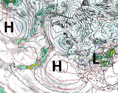
Not much has changed since our last post. This last storm was another overachiever. That storm has moved on and high pressure is going to setup along the cost. Our temperatures will gradually warm. Here is a look at the current weather: You can clearly see the ridge of high pressure that will dominate our weather. We could see a very weak slider this weekend, but by next week we will be back close to average temps. However, like everything else since we turned 2019, that is going to change when the next storm cycle comes in. We will start to feel the change around the 26th. Our ridge of high pressure is going to get bumped well south and that should open the storm door once again. Here is a look at the forecast for the 26th, notice the difference between the map above and the map below: You can notice the storms are beginning to stack up. Then around March 2nd, the next cycle of storms begins with the arrival of the first storm: Notice the distinct storm track around

El Nino is Underrated; 12 Days Until Next Storm Cycle

40 feet in 40 days. That is very close to what much of the Sierra has picked up in the last 6 weeks. Now, we can catch our breath for the next 10-12 days before the next storm cycle shows up. The next will be warmer with potential sub-tropical moisture, not unlike what we saw last week. Between now and then, we expect cooler than average temperatures. However, we will be moving closer to average by next weekend. Between now and then, we have a small slider that will drop down and reinforce our cold air. We do not expect much precipitation out of this one. Stay Tuned ...

Don't Like the Rain; Here Comes the Snow!

Image
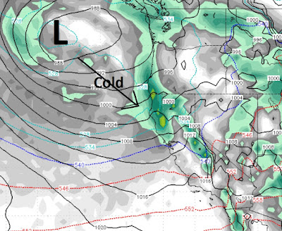
Heavy rain from 8,500 feet down to the valley floor for the entire Tahoe region. I would not be surprised to see some thunder and lightening as we are now in the most intense precip portion of this particular storm. That is all going to change. Starting this afternoon, snow levels will begin to fall. By tomorrow morning all this rain, for all our readers, will be snow. As usual the snow will be the heaviest in the mountains. Here is a look at tonight around 10:00, notice the blue lines now in our area, that is cold air, the red has been shoved well south: This very cold trough in the jet will continue to push south until we have snow all the way down to 3,500 feet. This will turn into a major winter storm and the NWS, rightfully so, is concerned about travel, especially over the passes, tomorrow and Saturday. I would not be surprised to see Mt. Rose pick up an additional 3-5 feet of snow. The upper layer should be of the champagne powder variety. Here is why this is poss

Don't Let Rain Fool You, This Will Turn into a Major Winter Storm by Friday

Image
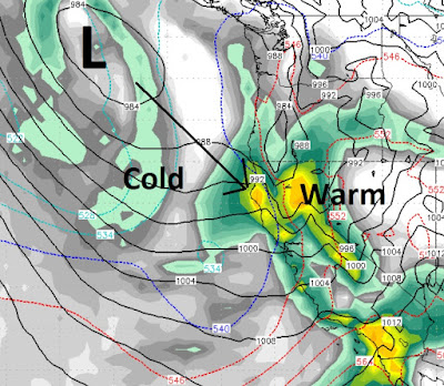
A massive Pacific storm is pounding the area with rain and snow. As was forecast, the snow started very low, but now the warm air is mixing and snow levels are shooting up. We still expect rain at 10,000 feet for at least a short period, but reports have been coming in with rain at 7,000 feet already. That will continue to climb. Here is a look at what will change the entire dynamic of this storm: As our moisture rich southern storm continues to pound the area with rain and high elevation snow, another, much colder storm is going to slam right into it. This will in all likelihood cause a major winter storm for all of the Tahoe area and the leeward foothills of Reno and Carson City with blizzard conditions similar to what we saw last Saturday. The timing looks to be around early Friday morning, but could be later as the cold air will mix in with the warm air, this makes exact timing very difficult to predict. We expect several reinforcing waves of cold air and heavy snow betwee

Grand Finale Starts - Now Lasts Through Next Weekend

Image
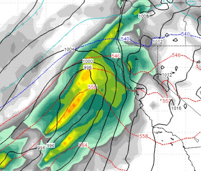
We talked about two storms colliding to form one very powerful storm. We also talked about high pressure moving in after the weekend and a third, very cold storm for the weekend. Now, the third storm is going to collide with the first two and produce a huge weather event that will last through next weekend. The wildcard is snow levels. They will definitely start very low and then rise rapidly as the southern storm infuses warm, subtropical air and moisture into the equation. Lots of it. Then, just as rapidly snow levels will plummet, all the way to the valley floor by next weekend. Here is what the European model (most reliable) is seeing over the next 5 days. The further north the red lines, the warmer the air: This evening (2/12), we are right on the proverbial Mason/Dixon line of warm and cold air. We believe snow levels will now start around 5,500 feet, which means all (or mostly) rain for the valley. Tomorrow (2/13) at noon, warm air dominating tons of moisture and prec

3 Cold Storms Poised to Rock Tahoe

Image
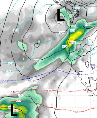
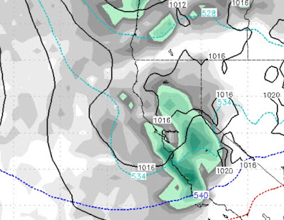
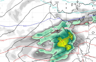
We are tracking 3 storms for the next week, all on the colder side. All taking aim at Tahoe. All impressive in their own way. The first storm is hitting us now, we talked about it last post. It showed up right on time. It will move quickly and be mostly out of here by noon tomorrow (2/10). This storm is ushering in a pretty impressive cold front. Anybody who was up on Rose today prior to the lifts closing down probably felt some of the coldest air of the winter. In our last post we talked about two storms converging on Tahoe from the North and South. Here is a look at the forecast for early Tuesday (2/12) morning: You can clearly see the two storms. These two storms are on a collision course and will actually join forces to become one big storm by Tuesday night: This storm is going to hammer the entire state of California including Lake Tahoe and surrounding area. This storm will clear out by Thursday at noon, not before dumping many feet of snow in our area and probably e

20 Feet of Snow in Last Month With More on the Way

Image
The weather pattern will remain very active with a series of storms bearing down on Tahoe.  Like our last few storms, these storms come in with very cold air and should be all snow for all Tahoe resorts. Remember, the later we get in the season, the tougher it is for storms to get over to our side of the lake. The first of the storms, will be shadowed almost entirely by the Sierra. In fact we are not looking for much precip anywhere, but what little falls, will be at the crest on the other side of the lake. Here is a look at the first storm which will begin to effect the area late Friday night (2/9): : This storm slams into the Sierra and then dips south. However, that will open the door for the next storm to drop in from the north. That storm will show up late Saturday afternoon (2/10) and will impact both sides of the lake: This storm should hang around throughout all of Sunday. The following week has several large storms, that will be warmer, that could bring even more

Storm Update - Leeward Valleys Could See Heavy Snow

For a complete recap of what is going to happen in the Carson Range and Sierra, see the last 2 posts. This update is to warn the folks who live in the leeward valleys (Reno and Carson), that the potential exists for heavy snow starting Sunday afternoon and lasting through Tuesday afternoon. We have seen this pattern before, as a colder storm drops down on a near perfect trajectory to spill over the mountains and into the valley.  The potential exists for 1-3 feet in the foothills and up to a foot on the valley floor. Mt. Rose could see as much as 6-8 feet of snow between now and next Wednesday! These storms will put us over our season average for a 4th straight year. As we like to say, averages have a way of catching up, so enjoy the great skiing and riding conditions! Stay Tuned ...