Posts

Today's Storm Strengthens, Wednesdays Get Colder

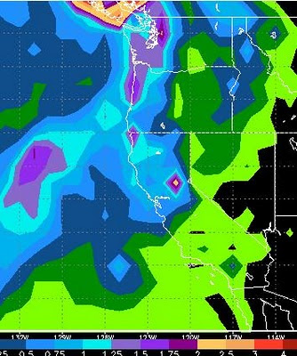
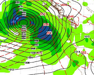
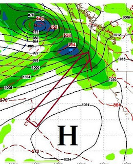
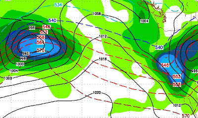
A large area of precipitation will move further west than I anticipated with my last post. This is really good news as we can expect 1-3 feet of snow at Mt. Rose by Tuesday Morning. Wednesday's storm, however, is losing moisture and gaining really cold air. The models are pretty much in agreement that we will not get a major precip event, but look for the bitter cold air to come in that I talked about in my last post. Amazing how fast the weather can change this time of year, so let's not count out Wednesday quite yet. After Wednesday we will become dry and temps will rebound, but only slightly. Looking way ahead, I see a stormy unstable period for 10 days, starting next Sunday. Stay Tuned ...

Three Storms, Each Getting Progressively Stronger

Image
Two Storms This Weekend I am tracking 3 storms right now that should play a significant role on our weather and more importantly what happens up in the mountains. The first storm is coming in Saturday night. This is a splitter and does not have a ton of moisture associated with it. However, right behind that storm, for Sunday night a much larger storm moves into our area that should bring some reasonable amounts of snow above 8,000 feet. Here is a look at the total precipitation through Monday afternoon: If these systems hold together, the western Sierra around Tahoe could pick up 1-2 feet of snow, with about half that for the eastern shore (Mt. Rose). Much Cooler Next Week Starting Monday and lasting for at least a week our temperatures will be much cooler, with highs in the upper 40's for the valley. The High Sierra will see below zero readings in some spots. This will bring snow levels down just in time for what appears to be a much larger storm that should track right t

Here She Comes

Image
Storm Still North, but Moisture Coming Our Way With Direct Hit The giant storm that I have been talking about for the last 10 days, is moving across the Pacific. The blocking high has weakened and it looks like we will be hit pretty hard by this storm in the way of precip. Snow levels, however, will be very high. Here is what the storm and moisture tail look like from space, notice the moisture tail wrapping around about 40% of the planet: Here is what we can expect Sunday morning: Here is a total moisture forecast by Monday night: Areas north and west of Lake Tahoe, could be looking at 3-5 inches of liquid precip. As far as Reno and Carson City, the models are not in agreement. However two models are talking about heavy rains on Sunday, especially in the western foothills. This is just the beginning. The models are showing a series of very large storms heading into the area. We will get a few days off next week, but come Thursday another large storm is heading our way.

Massive Storm Will Affect Our Weather

Image
The remnants of Typhoon Megi are going to get caught up in the westerly flow, cross the Pacific Ocean and Slam the coast of Washington State. This is a very large storm packing extremely high winds and lots of moisture. Here is a look at the storm as it approaches the Pacific Northwest on Saturday evening: If you have not seen these weather maps that I post, you can make out the Northern West Coast of the US on the right side of the image. Northern California is in the lower right corner. This storm will impact our weather this weekend. The NWS is calling for 1.5-3.0 inches of rain along the north shore of Lake Tahoe. Some of this rain will spill into the valley adding to our already record amount for October. Here is the GFS precipitation forecast. GFS is calling for lesser amounts in our area. The NWS gets there information mostly from the EC model: GFS has about 1/2 to 3/4 of inch of rain for Lake Tahoe and perhaps a 1/4 inch for Reno. Any snow associated with this very war

Storm For Next Weekend Update

Image
In my last post I talked about a rather large storm that the GFS weather model says will tap into sub-tropical moisture and produce copious amounts of precipitation. The weather models are starting to agree that a strong area of high pressure will settle into our south and west. This area of high pressure will probably push this large storm north of our area, giving us a near miss. Here is a look for next Sunday, notice the huge area of high pressure off the Southern California coast which is blocking the storm from coming into our area and pushing it well to our north: A lot can change in the coming week and the GFS model originally had this storm hitting our area. It is a large storm and with our already swollen rivers and saturated soil it might be best for this one to move north. These sub-tropical storms are usually very warm. Snow levels will start around 9,000 feet or higher. With last nights rain, Reno broke its all time record for total precipitation in the month of Octo

Winter Weather on the Way

Image
A system up in the Gulf of Alaska will split and send a weak low our way for Sunday and Monday. There is some decent moisture associated with this system. The GFS model has it hitting us pretty square and dumping some mountain snow above 8,000 feet on Sunday night. This system does have the potential of sending rain into the valleys Sunday night into Monday, with the possibility of Thunderstorms on Sunday afternoon. If you are planning on traveling over a Sierra pass south of I80, you may have some trouble Sunday night into Monday.  This is impressive enough for the NWS to post a warning. Cooler weather for next week improving by midweek ahead of the next system. The next system comes in on the 23rd and is much more impressive. This is a long way off, but if this holds together, we will have a 2 day snow event in the mountains that should register some decent accumulations. Below is what GFS thinks will happen the night October 23rd (Saturday).     There is another decent system

Dry Weather For The Next Couple of Weeks

Let's count our blessings for the stormy weather of last week. Parts of the foothills west of Reno received nearly 4 inches of rain. The higher elevations received over 2 feet of snow. That is free water. However, that snow will probably not stick around as our weather will be for the most part dry with seasonal temperatures. The possible exception to this is next Sunday into Monday. A system will approach from our north. The models have this system pushing down and giving us an opportunity for valley rain and mountain snow. That is a long way off. I will update if this system turns into anything substantial. There is a very strong MJO in the Indian ocean. That should move east out into the Western Pacific. What does this mean? There is a chance for a major storm brewing up in about 2-3 weeks as the MJO tracks east. MJO, which st ands for Madden–Julian oscillation, can be used as a predictor for our weather. A very similar pattern to what we are seeing now took place in 1996, alb