Posts

Finally, Mountain Snow Coming Our Way

Image
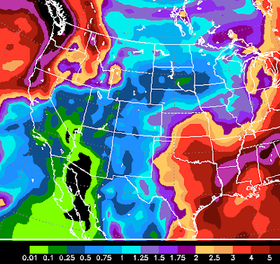
The latest model runs are in pretty good agreement that this next series of systems, brought in by a split jet-stream that looks to be putting Tahoe in the cross-hairs, should bring some good precip. The big benefactor here will be the Carson Range and Slide Mtn in particular. Snow levels will vary, but it looks like all snow at 8,000 and above. The timing of the systems starts late tomorrow afternoon and lasts through Thursday with on again, off again snow for the Sierra. These storms are weak, but are packing some serious moisture. Some models have 1.5 inches of liquid precip. I believe Slide Mountain will pick up between 12-18 inches of snow (at the top) by Friday morning. Depending on altitude, some areas on the west side of the lake could see 2 feet or more. Hey, better than nothing. Here is a look at the NAM weather model and what we can expect in the way of liquid precip: A small area of 2-2.5 inches west of the Lake. Around 1 inch for the Carson range. I believe those

Is There Anything To Look Forward To?

Image
The first time all year the models were leaning toward a winter storm. As quickly as they forecast it, they changed the forecast. This has been a very slow start to the year. The chance of anything decent being open by Thanksgiving looks very bleak. The next chance for the storm machine to get cranking comes on or about November 26th. However, the 30 day precip model is not terribly optimistic for any major storms coming between now and the 2nd week in December although it is looking at some moderate precip between November 26th and December 5th. Here is a look at the total precip forecast for the next 30 days, almost all of this comes after the 26th: You can see the storms will be creeping up on us, however the EC model (shown here) believes most precip will be to our north and west, where they will pick up 10+ inches of the liquid stuff. For our area we are looking at between 2-5 inches and that is being very optimistic. Couple that with seasonally warm temperatures and yo

Storms Weaken, Ridge Builds In

I may have jumped the gun with my last forecast. Like I said, I do not get paid so I can tell you what the models are hinting much more in advanced than the professionals. Next weeks storms have not only weakened, but a ridge of high pressure will move more north and west and block the weaker systems from reaching us. Therefore, never mind on next weeks storms, our string of gorgeous weather looks like it is going to last for at least another week or two. Stay Tuned ...

Changes Coming For Next Week, Maybe

Image
Ok, that extended golf season I promised did not disappoint. We had a beautiful stretch of weather that looks like it will come to an abrupt halt with the seasons first major winter storm next week. First I will talk about the storm or storms, and then I will caution you as I am only showing the GFS model. Late next Monday the fun will begin with a cutoff low moving precip into our area. Here is a look at the GFS forecast for next Monday evening: This is a weaker system, but it is ushering in what I believe will be a major change to our weather pattern. The real fun gets going late next week, somewhere around the 14th or 15th of November as a major storm moves down the coast and taps into some real decent moisture. Here is a look for the morning of Friday November 15: As always, not all the news is good. I have two concerns. First, the EC weather model is late in seeing this development. I believe it will fall into line, but as of yet it is calling for 2 inches of liquid

Extended Golf Season on the Way

With few exceptions, October should be a beautiful month in the Reno/Tahoe area. I know we received a few teaser storms, but all that snow will melt. Looking at the long range forecast, I am not seeing any major storms developing and coming to our area, possibly through October. Having said that, what about the upcoming winter? How much snow can we expect? I have read numerous articles trying to predict the long range forecast. The only thing they have in common is they have nothing in common. I have heard of a weak to moderate El Nino (aint going to happen, at least not until spring) and a weak La Nina (slight chance). My guess is we will stay neutral ENSO until at least late January. Therefore the El Nino Southern Oscillation is not going to provide us any guidance. Some pig was wagging his tail counter clockwise during the Wanning Gibbous Moon, therefore the Farmers Almanac says the USA is in for a bitter cold winter. I am not sure how much credibility I can give that, although

Smoke Report

Image
I have been asked by some of my loyal readers to give a smoke report for the Reno/Tahoe/Carson area. It seems the local weather people are unwilling to commit to anything. Since I do not get paid to do this, I will tell  you what the models and wind forecasts are telling me. Let's hope they are wrong. We have been in a straight southerly flow. That means our winds are straight out of the south. We are due north of the Rim/Yosemite fire and the wind has made a beeline to our area (DA!). I am seeing a change over that should result in a westerly flow, however, this will be short lived. This could improve conditions slightly for the next 12 hours or so. However we still have a very stubborn ridge of high pressure that does not look like it will move until Labor Day ... sorry. The GFS model has a low pressure system coming into our area. Buyer beware: the more reliable EC model has that system staying further north. In any event, it should be enough to push the smoke out by early

Ma Nature Throws Another Curve

Image
This has been a pretty amazing season. We started with what looked like a moderate El Nino which lead to an epic start of the season. Then the spigots were turned off, literally. Storms kept forming and approaching and dying. The weather turned warm and calm for much of the spring. Then summer showed up and the temps dropped off the table. So what gives? The simple answer is that nature is unpredictable. Even this time of year. Many years we struggle to get into our summer weather pattern. What makes this year different is the mild spring temperatures. Most readers thought Ma Nature was done until next fall. Not so fast. We have a surprisingly strong storm just of the Northern California Coast that has some very wet and cool air associated with it. The actual low is just off the Southern BC coast. The cold front is moving into our area today and will bring rain, clouds, wind and cool temperatures for the next couple of days. Below is a map of current conditions and trends. The co