Posts

66 Hours of Precip Coming to Tahoe Sierra

Image
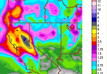
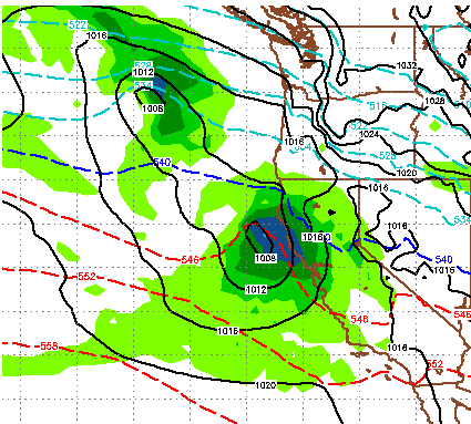
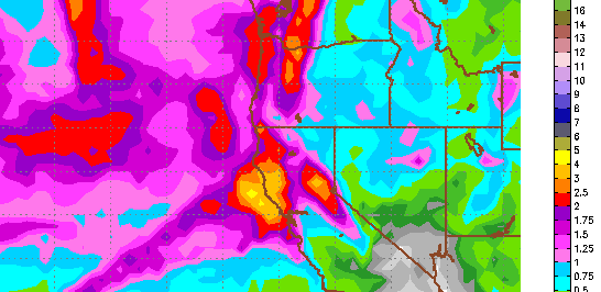
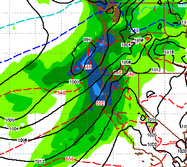
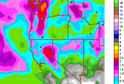
I just checked the latest model run and here is what I am seeing: Tahoe is in the bulls eye of a very large storm that will tap into a moisture plume known as the Pineapple Express. Starting at 4:00pm tomorrow (Friday) it will start snowing in the Sierra west of Lake Tahoe. Snow levels will start at about 5,000 feet. That moisture will spill over to the Carson range around 8:00pm. Precipitation will continue as snow levels rise. This is going to be a rapid rise. By Saturday around noon, snow levels will be between 7,000 and 8,000 feet. Those levels could reach 10,000 feet as warm moist air is sucked out of the Pacific moisture plume stretching from Hawaii to Northern California. At about 4:00pm on Saturday, a deep rich wave of moisture will enter the Sierra and Carson Range. This is where snow levels could reach as high as 10,000 feet and this storm could bring heavy rain to both the Sierra and Carson Range. Heavy moisture will continue until about 4:00am Monday morning for the

Storms Poised to hit Tahoe Hard

Image
Two storms are coming our way. In the next week (and maybe longer) Tahoe will see some very welcome precipitation. Storm 1 This storm is coming in tonight and tomorrow. It is the smaller of the storms and the cooler of the storms. Here is a look at the forecast for midday tomorrow: You can see we are right on the edge of the cool/warm air. What develops out of this storm is a giant moisture plume that will stretch from Tahoe to Hawaii. Some refer to this as the Pineapple express. Elevations could start as low as the valley floor but will rise through the entire event. We are looking at around 1-2 feet for the snow prone areas west of Lake Tahoe and about half that for the Carson Range. This should be all snow. Storm 2 As our next storm and much more powerful, wet storm approaches, we are looking at what I will call a major weather event for all of Tahoe. We seem to be right in the bulls eye. As this storm taps into a giant moisture plume, it will stall ... and dump. Howev

Dry Cool Weather Until Next Weekend, Then Good Chance for Winter Storm

Image
The cold front is firmly in place and we are going to get a few reinforcing shots of more cold air on Sunday and then again next Friday. We will get some light snow showers Sunday and Monday, however at this time it looks like accumulations will be minimal. Next Thursday is our next chance for some measurable snow in the Sierra as a shortwave will drop down out of the Pacific Northwest. Models in good agreement that will bring us some precip around Thursday with a cold front behind. Then as the PNA goes negative again, a stronger system will drop out of the Gulf of Alaska and should make it in to Tahoe with plenty of moisture. Of course we are still pretty far out, but models are in surprisingly good agreement and it appears that a number of factors will fall into place. This is the forecast for total precipitation next weekend: The possibility exists for some areas to pickup as much as 4 inches of liquid. With the colder air in place, snow levels for this system will be muc

Storm Update and What's Ahead

Image
This very quick moving, storm has brought very beneficial moisture to all of Tahoe and the western Nevada valleys. It is not quite over. I expect another 2-4 inches up at Rose by Tomorrow. Some models are saying more. The snow levels started very high, near 10,000 feet, and took some time to move down. Therefore the resort snow totals are relatively low with Rose being the winner and accumulating 8-12 inches. That number should increase to near 16 inches by Friday with an outside chance of slightly more. However the moisture impact should be significant because of the rain for nearly all resorts. We have been in a very dry spell and 2-3 inches of liquid precip has fallen in the Sierra all around Tahoe. The California coast will pick up more moisture come Sunday as a system moves straight down the coast. There is some chance that we could pick up some of that. I am focusing on a large storm for the following weekend, but that is still way out. Hopefully that holds together. Here i

As Storm Moves In, Will This Change Our Long Term Weather Pattern?

Image
A decent sized storm is poised to hit the Tahoe area and should leave behind 18-30 inches of snow for all areas around Tahoe above 8,000 feet. This storm, which is packing abundant moisture, will come in warm on late Wednesday. Snow levels will start out at about 8,000 feet. As the front moves through the snow levels will plunge to the valley floor by Friday morning. The Sierra Crest is forecast to pick up about 2.5 inches of liquid precip. Slightly lesser amounts can be expected for the Carson range. However, if you are a Mt. Rose skier, the elevation of Rose is such that it will be the big benefactor of this storm with all snow. I would not be surprised to see a couple of feet by Friday afternoon. The following is the EC total precip map for the event: We are very pleased to finally get some moisture in the forecast. Does this suggest a change in the long term outlook? Remember, many forecasters had written off 2014 altogether (See Ken Clark at Accuweather.com). Or, does thi

Dry Weather Continues; Historic 13 Months

Image
As the rest of the country continues to get blasted by a very harsh winter, one of the coldest on record, we have been very well protected by a ridge of high pressure which has moved up the coast and is keeping us in warm weather and sunshine. Hard to complain about the weather. This should continue for at least the next 10 days. I will talk about day 10 shortly. First I want to show some charts on just how dry our weather has been. This first map represents what is our traditional rainy season. Of course we know we were nearly shut out of any rain whatsoever. Notice almost all of Northern California has picked up less than 5% of the average rainfall for the rain season. Pretty Amazing and potentially catastrophic. The major reservoirs in California are in big trouble. When they should be filling up, they are getting no water. In addition they are all very low because of the record dryness of 2013 (See  Previous Post). I have been searching for the better part of two weeks

Suggestions For Changing The Weather Pattern

We like to have fun here at the TWB. If you are looking for hard core scientific data, perhaps you should read no further. I just wanted to let all my faithful readers know that I am doing what I can. In the last 2 days I have done the following: Washed Car, Inside and Out Cleaned Gravel and Salt of Garage Swept Driveway Removed Ski Rack from Car Number 4 could be the clincher! The above list usually brings in some inclement weather. I believe if we all put our collective positive energy together, we can change the pattern ourselves! I did look at both GFS and EC models and they are in agreement for a quick moving weather event on Sunday that could bring up to a foot of snow to the Sierra.