Stormy and Cold Through Friday
Again, my day job has prevented me studying the weather patterns. My apologies. Things should settle down in the coming months, I hope!
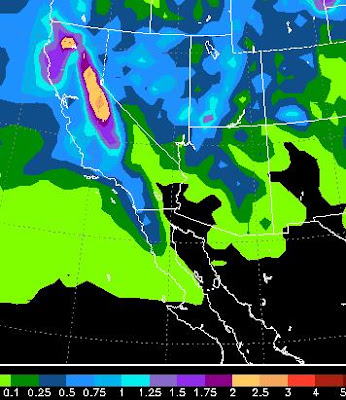
We are in the midst of a very stormy pattern that is going to give the Sierra good dumpage over the next 3 days. The majority of that will come late Thursday afternoon through Friday afternoon. We are expecting 2-3 feet at the Western Crest of the Sierra and 10-18 inches in Carson range, above 7,000 feet. The snow levels will drop as this system brings in a potent cold front. There will be some valley spillover in the form of rain and then snow late on Friday. Some areas in the foothills could pick up close to .75 inches of rain by Friday night. Here is a look at the precip forecast through Saturday afternoon:
Here is a look at the forecast for early Friday morning. This storm will effect Central through Northern California:
If you are worrying about water for the summer, we did pick up close to 250 inches of snow at the Western Crest of the Northern Sierra in March. That is nearly 3 times our average. This winter, which started so slow, is now going to come very close to average snowfall. These La Nina years are unpredictable, but the storms made a great comeback and continue to slam our area.
Starting Sunday we will slowly warm up ahead of our next storm cycle which should show up around the 25th - 27th of April.
Mt. Rose is closing this Sunday. I talked with management and they said that the season started out so slow that they did not make enough to cover the losses by staying open into May. Let the hiking season begin!
Stay Tuned ...
We are in the midst of a very stormy pattern that is going to give the Sierra good dumpage over the next 3 days. The majority of that will come late Thursday afternoon through Friday afternoon. We are expecting 2-3 feet at the Western Crest of the Sierra and 10-18 inches in Carson range, above 7,000 feet. The snow levels will drop as this system brings in a potent cold front. There will be some valley spillover in the form of rain and then snow late on Friday. Some areas in the foothills could pick up close to .75 inches of rain by Friday night. Here is a look at the precip forecast through Saturday afternoon:

Here is a look at the forecast for early Friday morning. This storm will effect Central through Northern California:
 |
| Early Friday Morning |
Starting Sunday we will slowly warm up ahead of our next storm cycle which should show up around the 25th - 27th of April.
Mt. Rose is closing this Sunday. I talked with management and they said that the season started out so slow that they did not make enough to cover the losses by staying open into May. Let the hiking season begin!
Stay Tuned ...