Storm Track Shifts North, Storms Stacking Up
The storm track for our latest weather system has shifted north and Tahoe is now right in the bullseye of the storm. This is a major storm for this time of year and will last through most of Saturday with high winds and lots of precip, mostly snow above 7,000 and perhaps lower.
Most of the major precip should be over by late Saturday afternoon. However, we are talking about a lot of rain and mountain snow between now and then. The possibility exists for a major snow event for the leeward foothills around 5,500 feet and above as the NWS is having difficulty pinpointing snow levels with this very unusual storm. If you live in one of those areas, be prepared.
The next storm we are tracking comes in next Wednesday, April 12th. This looks like an abnormally large spring storm again:

This storm has adequate moisture and will come in warm we believe right now. Our best guess is 7,500 feet. This system will stick around until late Friday afternoon.
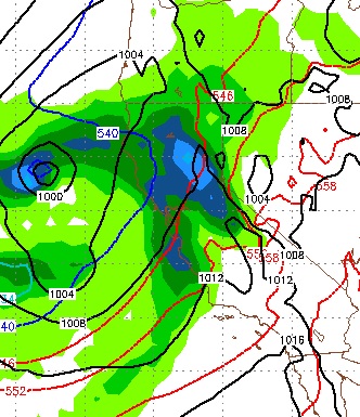
We are tracking another abnormally large spring storm that could come in around Tuesday the 18th. It appears to be following in the footsteps of the first two storms. Speaking of the first two storms, here is the precip forecast:

Folks, there is a good chance that Mt. Rose could pick up an additional 3-7 feet of snow in the next week with what appears to be more on the way.
Nice to have Paul Huntington back, his crystal ball seems to see just a little further out than others! If you have not read his post from last column, you should.
Stay Tuned ...
Most of the major precip should be over by late Saturday afternoon. However, we are talking about a lot of rain and mountain snow between now and then. The possibility exists for a major snow event for the leeward foothills around 5,500 feet and above as the NWS is having difficulty pinpointing snow levels with this very unusual storm. If you live in one of those areas, be prepared.
The next storm we are tracking comes in next Wednesday, April 12th. This looks like an abnormally large spring storm again:
This storm has adequate moisture and will come in warm we believe right now. Our best guess is 7,500 feet. This system will stick around until late Friday afternoon.
We are tracking another abnormally large spring storm that could come in around Tuesday the 18th. It appears to be following in the footsteps of the first two storms. Speaking of the first two storms, here is the precip forecast:

Folks, there is a good chance that Mt. Rose could pick up an additional 3-7 feet of snow in the next week with what appears to be more on the way.
Nice to have Paul Huntington back, his crystal ball seems to see just a little further out than others! If you have not read his post from last column, you should.
Stay Tuned ...