Slider Will Usher in Cooler Air; Coastal Ridge Digs Deeper
The cold front we talked about last post is right on time and we are sticking with 8-16 inches of champagne powder for Rose. The deeper the less likely for skiers and riders to break through and scrape the crust underneath. I am fairly confident we are looking at a good 10 inches and if things go just right up to 16 inches.
Then the ridge digs deeper. The coastal ridge in the jet is causing storms to go well north of us. This storm for tomorrow is due to that ridge flattening out. Here is a look at tomorrow:
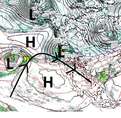
One sneaky little trough in the jet is going to allow this moisture starved slider to drop in straight out of the north. However, there is a substantial cold front associated with this storm and snow ratios could hit 15-20 to 1 depending on the timing of the moisture and cold air. The above graphic shows the ridge of high pressure in jet stream. This is causing all weather to move north around the ridge and will keep us high and dry for some time, unfortunately.
Here is a look at the ridge as it sets up on Tuesday:

This time the ridge is going to stay in place for at least a week and probably into January. It will be cold with inversions and poor air quality for the most part. However, this storm and the cold weather could leave us a white Christmas, certainly in the foothills above 6,000 feet.
The NWS has a better crystal ball than we do. They are hinting that a storm could be in the works for the 26th. We have been watching this storm for a few weeks and right now, to us, it looks like it is going north.
Stay Tuned ...