A Couple of Near Misses in the Next Two Weeks
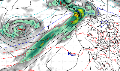
Wow, Ma Nature is really being fickle here. Our persistent ridge of high pressure is being bounced around, but will still block any major storms from reaching the area for the next 10-15 days. Here is a typical example, notice the ridge providing a perfect block from storms making it into Tahoe:
We will return to much cooler air in about a week as well as an Arctic Front makes its way down and gets far enough west to effect our area.
At least the Pacific NW is getting storms now. That could bode well for the 2nd half of March.
Mt. Rose is up to 300 inches of snow for the year, which exceeds most predictions out there. Of course we predicted 330 inches for this year and that guess is starting to look eerily similar to last year. Perhaps next year we will predict 600 inches!
Stay Tuned ...
