Posts

Ready or Not, Here They Come

Image
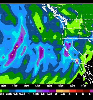
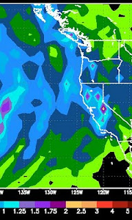
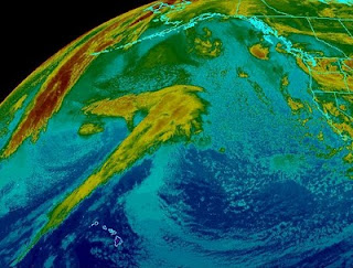
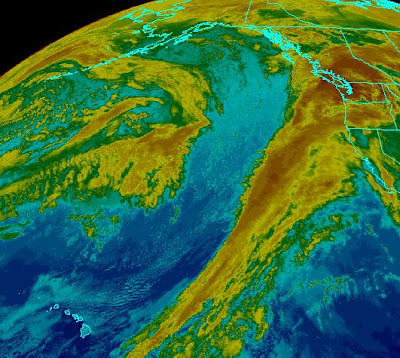
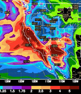
The current pattern will continue for at least the next 10-15 days. There will be nice days surrounded by very stormy days. A very impressive storm is coming in Friday and Saturday that should dump 2-4 feet of snow in the Sierra. The NAM model shows this in the way of liquid precip, notice some areas of the Sierra could receive upwards of 4 inches, which could translate into 3 or more feet of snow:   Looking ahead, we will have a few nice days to start next week before the next system comes in late Tuesday through Wednesday. Looking way ahead, a series of larger storms appears poised to hit us starting Saturday, March 6th and possibly lasting through all of the following week ... but let's not get ahead of ourselves. These systems appear to be rain for the valleys. Couple that with warmer March weather, and the golf courses should be coming back online soon. Stay tuned ...

Nice Weather - Don't Get Used To It

Image
As I wrote about a week ago, things are looking really nice for this week. The valley's could start to push 70 by Wednesday or Thursday with sunny skies and reasonable winds. Enjoy it while it lasts, because it aint lasting long! A number of factors are starting to come together that should provide a fairly sustained period of very stormy weather starting this weekend and lasting into the foreseeable future. Without getting too detailed, the high pressure ridge will move east and the vacuum will be filled by a sub-tropical jet which will bring storms to all of California and the Sierra. Here is an interesting chart. This is the total precip from Sunday to Tuesday. Which should get a healthy shot, but look west. All that is heading our way as well:   Here is a look at a GFS chart for Sunday morning: The storm track should come right over Central California. Not getting too far ahead, a rather large storm looks poised to hit us on March 1, with several smaller storms co

Spring Like Weather Is Coming - El Nino has passed its Peak

We have a cold little system that will be moving through Tuesday and Wednesday. It will bring minor amounts of snowfall, < 12 inches for the Sierra. The models and the PNA forecast suggest that a weather pattern change is coming. That change is for much warmer, dryer conditions starting as soon as Thursday and lasting for perhaps a week or 10 days. There are some indications that a much larger storm could be in the works around the 20th of February. However, this year has been nearly impossible to predict weather. In fact the Reno NWS folks oftentimes have trouble predicting what will happen in 6 hours, let alone 2 weeks. I will keep an eye on that one. In the meantime, polish up those clubs as we could see some 60's not too far down the road. Meanwhile, NOAA is suggesting that El Nino passed it's peak in Late January and beginning to weaken across the entire equatorial Pacific, especially in the mid-pacific regions. The site when on to say that we should expect neutral co

Decent Storm for Friday and Saturday - Nino Coming Back mid-February

Image
Another decent sized storm is headed our way starting Thursday night and lasting through Saturday. There are a series of very weak disturbances that will come through leading up to this event. First here is a moisture chart for this weekends storm:   Most of the Sierra is poised to receive 1.5 to 3 inches of liquid precip. I should say this is the GFS model, which consistently under predicts moisture totals. My gut tells me the storm will produce around 18-36 inches of snow for most of the Tahoe Sierra, with a larger band down around Kirkwood. Here is a look at the storm as it approaches Thursday night. It is a decent sized storm coming ashore to our north: As it looks today, the best time to hit the pow will be on Saturday. But conditions should be excellent Friday through Monday, especially in the back country. Keep an eye on the avalanche conditions before setting out. You can check them here: Sierra Avalanche Center Looking longer range, the models are starting to point a

Next Storm Late Sunday and Monday

Image
We can officially say goodbye to the Pineapple express, for now. Take a look at the following Satellite picture compared to the prior post: Gone but not forgotten. We have some incredible conditions up and down the Sierra. Scott and i spent a day in the Chutes yesterday, and it was unbelievable. Here take a look: The snow was deep, the crowds small, the temps perfect ... and it was snowing hard. We talked with a ski patrolmen and he said the snow was perfect. According to him they threw bombs all over the chutes and everything held. When we got in there, it was waist deep in most places. Most of the rocks were covered up as well. This storm cycle is not quite over. If you look at the satellite image above, there is still a pretty strong storm out in the Pacific and it is headed our way. It will weaken and make shore north of us where it will split. It still should have some pretty good strength to send some moisture our way for Sunday night through Monday. The northern sectio

The Pineapple Express

Image
Oftentimes we have heard about a weather anomaly in Tahoe called the Pineapple express. That anomaly is a combination of many factors including the southern jet stream and sub tropical moisture plume. For the most part it represents a huge swath of precipitation stretching from Lake Tahoe all the way to Hawaii. Get the picture? No? Here take a look: This moisture is stretching a little too far north for us to see the epic storm conditions that normally happen in a Pineapple Express. Last Storm in The Cycle As you can clearly see, however, we are not done. In fact the largest storm is about to come in an blast us starting this afternoon and lasting through most of Thursday. This storm should bring us an additional 3-5 feet over the crest. That should translate to around 2-4 feet at Mt. Rose in the Carson Range. Believe it or not, the majority of energy for this storm is heading well south of us. We are on the northern edge of the storm. Here are the totals for this storm alone:

Wednesday Afternoon (1/20) through Thursday Night (1/21)

Image
In our continuing series analyzing the storms that appear stacked up and ready to pummel Tahoe and even, to a now greater extent, Southern California, we will look at Wednesday and Thursdays storm. As the super charged, 200+ kt Jet Stream moves south, so too do the track of the storms. There will be plenty of precip left for Northern California, just not as much as we once thought. First, let's take a look at total accumlated precip for the week, this is pretty impressive: Almost all of California is in the 5+ inch range. Like I said before many of highest elevations in the Sierra, especially the central Sierra around Mammoth and Yosemite will see 10-20 inches of precip. Now let's focus on Wednesday and Thursday. The good stuff will start around 4:00 pm on Wednesday and last through the night into the early hours of Thursday morning. There will be a short lull about 4:00am on Thursday until about 10:00am. Again, this might be a good morning to hit the pow. Then shortly