Posts

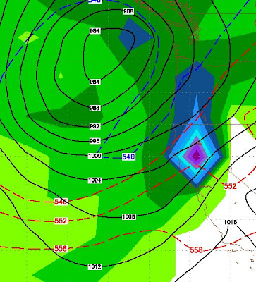
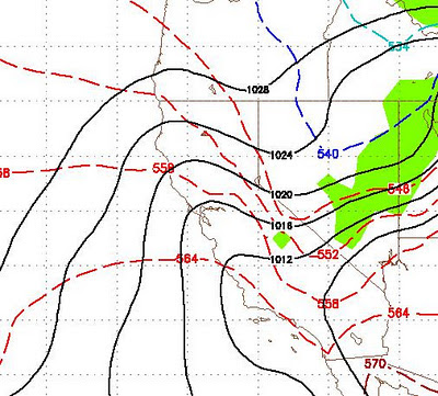
2 Strong Waves Coming To Tahoe

I am currently enjoying 85 and sunny weather in Florida. I noticed that the weather has been summer like since I left town. The last time I left town was January. When I returned they were calling it June uary. Well, the good news is that I am coming home. The really good news is that we have 2 strong storms heading our way in the next 10 days. The first should be here on Friday and should last the weekend. The next arrives the following Wednesday and looks like a giant storm. When I am back in my office tomorrow, I will fine tune this forecast. Stay Tuned ...

Storm Late This Week Should Open Door For Possible Larger Storms

The larger storm for late this week that I have been tracking is going to slide down the California coast and make shore in Southern California next weekend. It will have little if any affect on our weather. That is the bad news. The good news is that it should open the door for a series of storms to follow in its path and hit the Tahoe area starting in about a week. The first of those storms should roll in mid day Sunday the 13th. EC has this as a decent storm for our area while GFS has it breaking up and only having a minor affect on the area. I will keep a close eye on this. The next storm should roll in late in the week, around the 18th or 19th. GFS has this as a decent storm, EC does not go out that far. I will be traveling, but should have time to post an update this weekend. Right now it looks about 50-50 to having the upper mountain open by Thanksgiving. Stay Tuned ...

Tricky Weather Pattern Emerging

Image
As the first storm in our 1-2-3 punch approaches, models are pretty consistent. The Sierra will pick up some snow but it will probably be amounts in the low range of my forecast earlier in the week. On the heels of this storm comes another for Sunday and Monday. Again, this storm looks as though it will develop a north to south trajectory and snow amounts again will fall into the lower range. To fine tune the forecast, I am now looking at about 1-2 feet of snow by Monday evening, likely in the lower range. The real tricky development comes Thursday of next week. The GFS model has a huge storm moving south and west right into our area. However the EC model has the storm moving south and getting trapped out at sea and having little to no effect for our area. Here is what GFS shows for early Thursday: Again, EC could not be more in disagreement with the GFS model shown above, here is what EC believes will happen to this storm: If GFS is correct, we could be looking at 3-5 inches o

Storms Strengthen, Looks Like 1-2-3 Punch

Quick Update: Tonight the changes begin with a deep cold front dropping down to our east but hitting our area with strong winds and much colder temps. Thursday Night / Friday: Strong trough drops in and dumps 6-18 inches in Sierra, slightly lesser amounts for Carson Range. Sunday Night / Monday: Similar storm drops another 6-18 inches for both Sierra and Carson range. Wednesday / Thursday: Stronger storm drops 1-3 fee for both Sierra and Carson. As advertised, winter almost here. I will continue to update these storms as they approach. Take this into consideration when driving over mtn passes! Pondo could be spinning in a week. If all goes well ... who knows? Stay Tuned ...

Winter is Coming to the Sierra

Image
The beauty of living here is that between the stormy days we usually have nice weather. Since mid-June, we have had only a couple of stormy days and very nice weather. However, it is that time of year when we can expect the storms to start dropping south again and pummeling our mountains. Fall has been beautiful, but that is about to come to an abrupt halt! The first storm will actually come ashore up in Oregon, move inland a few hundred miles and then drop south. This will usher in a pattern change and much cooler, windier weather. Here is a quick peek at Tuesday, early morning (Notice the isobars being very close together, that means wind!). This storm will not bring much if any precip. Any precip that does accompany this storm will have a greater effect on the valley than the mountains: Starting next Friday, November 4th, a series of storms are headed our way that could last through the following Tuesday. Right now the models are not agreeing as to the amount of precipitation.

Weather To Remain Nice Into November

Nice is a relative term. However that is what we are going to get. Very mild weather with lots of sun and no storms. There is an indication that the pattern could change toward the beginning of November and I will keep an eye on that. Until then enjoy the beautiful fall weather. We will get ours, it is now just a matter of time!

Weather Will Turn Mild and Sunny

Looking down the road, our weather is going to turn mild and sunny starting Saturday and lasting for what looks like a couple of weeks, at least. Expect daytime highs in the mid-70's to possibly low-80's. So take the golf clubs back out and enjoy. This rain should have been very beneficial for the mountain bike trails as well! Next time you hear from me, I will have a storm in sight! Stay Tuned ...