Posts

Wild Week of Weather

Image
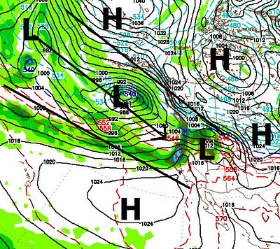
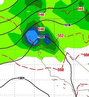
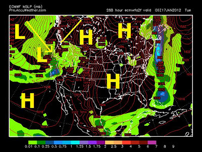
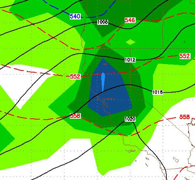
Update The timing and precip amounts that I talked about yesterday remain right on as of this morning's model runs with the possible exception of the Friday/Saturday storm bringing more precipitation. Snow levels are the concern here and remain so. Looking at things right now, it appears as though the Thursday storm will start cool and then a warm air overflow will bring snow levels up. The thinking now is everything above 8,000 feet will be all snow. The large storm set for Friday/Saturday is becoming even more impressive. The west to east trajectory will allow this storm to pick up copious amounts of moisture. The latest GFS run has this storm dropping 6 inches of liquid precip over the crest all in the form of snow. It looks like snow levels for this storm will be around 7,000-8,000 feet as well. The storm that I had slated for the following Tuesday, looks like it could show up a little earlier. I will talk more about that one when it gets closer but suffice it to say, it l

Prepare For Major Changes

Image
Starting today, prepare for major changes in our weather pattern. Tonight a cold front will be coming through the area. It will snow some in the Sierra, but probably not much. It will bring very cold air that will plunge low temperatures on Monday night into the single digits. This is just the first of a 4 part wave to hit the area. When all is said and done, expect 5-10 inches of liquid precip in the Sierra. The 2nd wave comes through on Thursday. There are some concerns about snow levels with this system. Right now the NWS is predicting the majority of the precip will be rain under 9,000 feet, especially just south of here. That could make it down to 8,000 feet and we will monitor as this 2nd wave approaches. Here is what GFS thinks for Thursday late morning: Late Thursday Morning 1/19 The third and biggest wave is set to come in Friday afternoon and last through Saturday. This system also is raising some concerns about snow levels. Here is the GFS look for Late Friday: L

Favorable Pattern For Good Healthy Dump

Image
As you know, I have  been tracking a number of variables for the past couple of months. Not the least of which is the cold air bottled up in the Arctic. That air is finally being tapped and released. In addition, a blocking area of high pressure is about to setup west of Hudson Bay. That will block storms from the north and force them south. Our blocking area of high pressure is about to get rubbed out and moved south which should open a very adequate moisture tap. What does all that mean? Dumpage for Tahoe and possibly a good healthy amount. Currently all the models are pointing at this taking place around the middle of next week. The following shows how things set up for next Tuesday, January 17: Notice the blocking ridge west of Hudson Bay. That will force storms down the coast. That arctic air will also invade the midwest as it spills out of the north. What does all this mean? Right now the models are all over the place on just how much precip for Tahoe. Here is a look at the

12z Model Runs Backtrack From Last 3 Days

Image
Near Term (1-2 Weeks) I was all set to show you a significant pattern change. Then I took a look at the latest run of the models and could hardly believe my eyes. Yesterday morning, the 3 long range models seemed to be in agreement that 7-9 days would bring cooler, stormier weather to our area. Because the models have been for the most part worthless this year, I decided to take an extra day. Today, the models are all over the place, and from everything that I can see, we will stay in the dry pattern for at least a couple of weeks. The EC model is suggesting around the 20th, our blocking ridge of high pressure could be shoved south and west, however GFS keeps the ridge in place and all the cold air well to our north. This is extremely frustrating as this weather pattern has been in place since the middle of October. At least for now it is only showing faint signs of changing. Even if we do get a change, it will only be small storms for the area. The reason? MJO (Merridian-Julian Oscil

Strong Signs Emerge For Stormy Pattern Starting Around 1/15

This will be a very quick post. I have been tracking what looks to be a major change in our weather pattern for the last 2 weeks. However, I have been reluctant to talk a great deal about it, mostly because of the winter, or lack thereof, we are currently experiencing. Checking the latest runs of the weather models, the AO and the PNA, I have noticed that all signs are pointing at winter coming to Tahoe around the the 15th of this month. I am heading up to Mt. Rose to catch the early morning corduroy. This afternoon I will lay out my case for this change coming in about 6-8 days. Stay Tuned ...

High Pressure to Dominate Our Weather for the Next 10-15 Days Before Major Change

A Strong area of high pressure is going to move into our area and produce unseasonably warm temperatures and continued dry weather into the foreseeable future. I have checked with a number of weather models and they show no chance of even a passing storm for our area in the next 10+ days. That is the bad news. The good news is that we are finally seeing indications from multiple sources that we are in for a major change between the 12 - 17th of this month. I do not want to jump the gun here, but over the course of the next week I will start to make my case for winter finally coming to Tahoe around the middle of January. This weather has been unprecedented since weather data has been kept. On another note; I hopped on some of the first chairs at Mt. Rose the last couple of days. Saturday was pretty good, Sunday was truly remarkable. Perfect corduroy on all runs. Remember these conditions are being made with snow supplied by man and not God! Again truly remarkable. If you have not been

Changes Still Coming, But Ever So Slow

Image
Changes should be coming to the Sierra in about a week to 10 days. However with all the cold air still trapped in the arctic, the storms headed our way are weak. In fact the Pacific born storms are all weak. We are about to conclude our driest December in the last 130+ years, with no measurable precipitation in the Central and Northern Sierra. Having said all of that, the changes that I have been forecasting are still en route, but ever so slow. GFS has a fairly weak system coming ashore around the 5th of January, however this system will die as it attempts to rise above the Sierra. Here is a forecast look for the 5th along with the total forecasted precip through the 10th of January. 1/5/2011 Total Precip through the 10th Again, without the cold air, we are not seeing storms of any significance. Right now we need about 6-10 feet of snow just to open most ski areas completely. Right now I do not see that happening any time soon. Having said that, many of the long range mo