Posts

Deep Low Pressure System Approaches, Heavy, Wet Snow on Tap for Sierra

Image
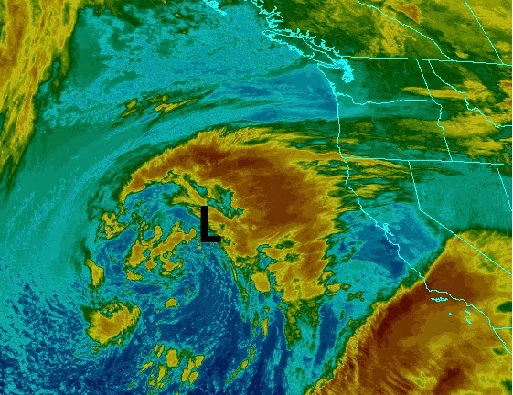
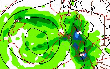
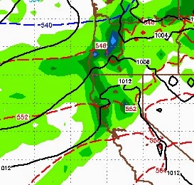
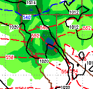
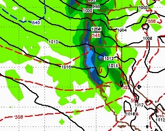
A deep low pressure system will tap into ample moisture to our south and bring rain and snow to the Sierra and most of California. Snow levels will be very high for this storm and I do not expect any snow to make it anywhere near the valley floor or even the eastern foothills. Here is a look at the current weather: This is a big wet, warm storm. I think elevations above 8,000 feet will see all snow. Below that will probably be a mixture. Lake level will see most if not all rain. The leeward valleys will also see rain, perhaps as much as a half inch. The further west you go from there, the more rain you will see. As the storm approaches tomorrow night here is a look at the foreacast: The first wave will hit Tahoe and south pretty hard. Very beneficial rains will fall through Central and Southern California. Mammoth is going to get slammed.  The second wave comes in Wednesday night and should center its attention on Tahoe: As the storm moves on shore, it will

Storm Delayed, Models Show Weakening

Image
The large storm that I talked about last post is being delayed, heavy traffic out in the Pacific. However, we are still in for a stormy 5-7 days starting tomorrow around noon. Several waves are poised to come in and hit us before the main storm makes its way to us on Tuesday of next week. Here is a look at the forecast for late Tuesday night: Here is a look at the total liquid precip being forecast through next Wednesday: If you read my last post you will see the forecast has decreased the amount of total precip, Especially for the Carson Range as this storm will be Shadowed by the western Crest to a certain degree. However, by next Wednesday, most Tahoe ski areas should have much more snow to work with, I would say upwards of 3 feet. Again, Mt. Rose with it's high base should make out well. This storm will come in warm and as the cold front moves through, snow levels will plummet. I would say all snow above 7,500 feet. Looking further down the road, I am tracking two v

First Large Storms of the Season Could Arrive Next Weekend

Image
Picking up where we left off, last post, conditions have been ripening for a more serious storm cycle to come to our area (finally). I am seeing things in the shorter term models that are now aligning with the longer term models (see fantasy forecast from last post). I must say, I am very excited with anticipation. Just a quick disclaimer, we are still 5-6 days out so things could change, but here is what the most reliable weather model is saying today and has been hinting at for the last 3 weeks. I will take you through a series of forecasts starting very late on the 28th; Friday November 28th 11:00pm, Storm is still to our west but a large plume of moisture is starting to form: Saturday November 29th 3:00pm, storm increases in size and begins to stall with the center just off the coast of Northern California. Sunday November 30th 4:00 am,  storm has completely stalled and is picking up strength Monday December 1 1:00am,  storm has spun up into one of the most

Models Trending Upward for Precip over the next 3 Days; Long Range Looking Good

Image
Checking the latest run of the EC weather model, I notice that it is trending upward for precip potential for Saturday afternoon's storm (see last post). Here is an updated look; seems the wave has a little more moisture to work with: We are now looking for up to 2 inches at the Crest and perhaps half that in the Carson Range. Snow levels are a bit tricky, but I think anything above 7,500 will be all snow. As the front passes through snow levels could drop to the valley floor. However, no valley accumulation is expected. Just as a disclaimer, the NWS is not seeing this and is predicting a dusting to 2 inches at the Crest and a whiff for the Carson Range. I guess we will see as I am looking at 2 feet at the Crest and probably a good foot of snow on Slide Mountain (and maybe more) by Sunday afternoon. Fantasy Forecast I have been watching the EC 30 Day weather model, which surprisingly is in disagreement with their Deterministic (10 Day) weather model. The Long Range has a se

Weak Storm Cycle Starts Up Thursday

Image
A series of small storms are headed our way starting very early Thursday and lasting through Sunday. I do not see any major precip events, but before all is said and done we could see a few feet of mountain snow around the crest and about a foot in the Carson range. There are 3 distinct waves headed our way. Wave 1 Earl Thursday Morning Wave 2 Early Friday Morning Wave 3 Late Saturday As you can see for yourself, the 3rd wave is the biggest of all, but still not very impressive. Here is a look at the total precip for the 3 waves combined: The Western Crest of the Sierra could see some areas in the 1-2 inch range, especially north. The Carson range is in the .5 to 1 inch range. That will translate into about a foot of snow by next Monday above 7,000 feet. Probably not enough to fill up the ponds for the pond hockey players. I continue to read that things are setting up nicely. Traditionally this sort of setup can usher in larger and wetter storms. However

Nice Weather Continues for about a Week

Image
Summer/Fall have been very stubborn to leave. With just a few exceptions, Old Man Winter has been nowhere to be found. However, we live in Tahoe and we are due, so you know that is going to change. I am picking up a change in the pattern coming around Thursday of next week. The culprit (for our nice weather), as usual, is the high pressure ridge which is setup just off the California Coast. There are indications that we could slide that ridge south and allow the storms to start to effect our area. Here is a current look at our weather. Notice the high pressure ridge and how it is blocking any storms from our area: Here is a look at the middle of next week, notice how the ridge has slid south opening the door for at least some storm activity: Right now, the storm on tap for next Thursday looks like it will weaken as it approaches the Sierra. However it could hang around for a couple of days and it is still 6 days out so a lot can change. Here is a look at very early on Thu

First El Nino Storm, Turbulent November in the Cards

Image
A smallish storm sitting off the coast of Oregon is having an effect on our weather and will continue to do so. Tomorrow ushers in some moisture that should be snow in the upper elevations. The storm will weaken as it moves inland and therefore the amount of moisture will be limited. Here is a look at the forecast for very early tomorrow morning: This storm will bring a healthy amount of moisture to the Northern California coast, but lacks the lift to make it far into the Sierra with any kind of significant moisture content. 6-12 inches are possible on the western crest with up to 6 inches in the Carson range, above 8,500 feet. If the models get this wrong, we could see even more, so keep your fingers crossed. Looking ahead, the westerlies start to show up around the 1st or 2nd of the month. A storm, straight from the west, will have an impact on Central California and our area. Here is a look at the forecast for November 2nd: As with most storms from the south and west, th