Posts

Pattern Change by Months End?

Image
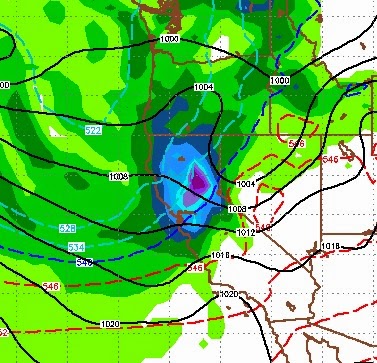
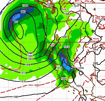
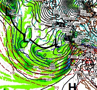
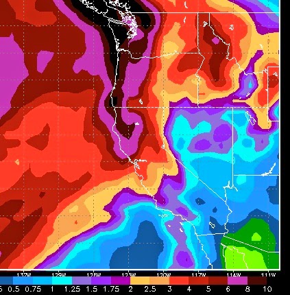
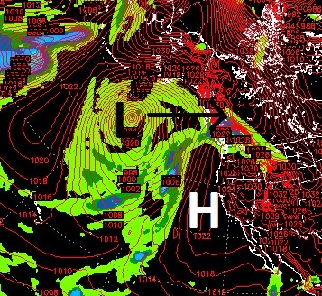
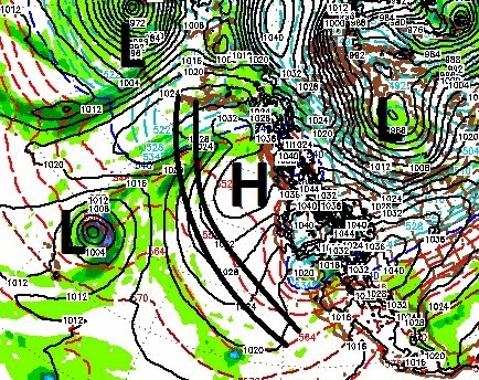
I understand that I am beating the proverbial dead horse, but we are due for something big. Over the last 3+ years we have seen below average, and in most cases, way below average precip here in Tahoe. It is even worse south of here. Averages exist for a reason, the world does not change overnight so I still fully expect a major pattern change to usher in a very wet spring. Having said that, I can base this on no scientific data, historical data, weather trends, oscillations or anything else, at least not consistently. By no means am I complaining about the near perfect weather that we have seen around Tahoe for quite some time. But, enough is enough, we live in the snow belt and it is about time we got some snow. The GFS weather model, for the past couple of days has been hinting about a pattern change. That change could come as early as the 26th or as late as the first of March. Interestingly enough, today the EC weather model joined the party. The GFS is more aggressive, but EC

Next Storm Up

Image
What a pleasant surprise when TWB forecasted the most precipitation and this time we were wrong on the low end. If you read last column, we were looking for 18-24 inches in the Carson range above 8,000. The NWS called for snow levels to be as high as 10,000 and a large rain shadow effect to be in place. Sub-tropical moisture will be the deciding component for this next storm. This storm is currently just off the coast of Northern California. It will move almost due north staying off the coast. It's outer rings, however, will tap into another sub-tropical moisture plume and bring that moisture up and through the Tahoe area. I expect snow levels to start at about 7,500 feet. By the time it is all said and done, those levels will drop to around 5,500-6,000 feet. Here is a look at the forecast for around 10:00pm tonight: I believe the Carson range and Mt. Rose will pick up another 14-30 inches of snow from this one. I see a better trajectory and a strengthening storm. Foreca

Our Turn

Image
Averages are averages and finally, for the next week, starting tomorrow .... its our turn! A massive storm is poised to make land in central BC and the southern rings will pull moisture from the south in the form of atmospheric river and slam Northern California, including the Tahoe area .... finally! Much needed precipitation is coming in and should start for the Northern Crest tomorrow afternoon. This is a big storm, but the better news is the series of storms pictured above is going to cut south and slam us, head on, with another storm starting around late Sunday. The following is the forecast for around 5:00pm Sunday: Here is the precip totals for the two storms combined: While this is all good news for farmers and drought mongers alike, snow levels will be very high. We will also have a pretty strong rain shadow effect along the Sierra crest that will limit snowfall (somewhat) in the Carson range. Those snow levels are forecast to be around 8,000 feet for most

Dry Weather Looks to Continue Into February

Image
Apparently 1977 was a brutal drought year. We are on our fourth, but I just read an article that many of the charts are extremely similar to this year. I know this is very little consolation, but in 1977 things changed around the middle to end of February. NOAA is predicting a storm for Tuesday, but I do not see it. I would be very surprised if we pick up even an inch. It will cool, but only slightly. From what I can see, our change looks to be coming around the 10-12th of February. A number of factors are going to affect this change and I will keep an eye on them. Until then, I apologize but not much to say other than to enjoy the beautiful weather. Fantasy Forecast Here is the 30 day precip chart from the European model. Almost all the precip it see's comes starting on the 12th or February. The GFS long range is seeing the same changes. Keep your fingers crossed! Please remember this; averages are made over a very long period of time. Our climate is always changing bu

As Storms Approach, They Die ... Dry Outlook

My hope was a few good storms for the 2nd half of January, however that is not looking so good right now. I have just checked the short, medium and long range models for our area; things look dry especially for the next 10 days. The storm I talked about for the 17th will show up, weaken and barely have an effect on our weather. There will be very little if any precip. What is even more depressing is the long range model, which shows almost no activity for Tahoe in the next 30 days. That has changed from what it was showing. A number of factors are responsible for this dry spell, too many to talk about here. Looking at the precip totals, they are also very depressing, about 30% of average. Could we be in for our 4th straight below average year? A monumental change would need to take place to avoid this. Now the bright side; We will get snow in Feb and March. Hopefully things turn around and we make a nice comeback. I do not believe that over the last 4 years we have changed our cl

Storm Update (or lack thereof)

Image
If you read my last post, I was tracking a long term possibility of a storm coming in for around the 11th or 12th of January. However, the models are now pointing to our ridge of high pressure stubbornly staying over our area for around a week after that. Here is a look at our current situation: Hard to complain about beautiful weather, but I think we all realize we need some snow. Talking to Sven over at Unofficial Mt. Rose , they have not seen 4 straight dry years. I believe they have lived here nearly forever! That tells me we are due. I know, I sound like a broken record. But if you came here to get a depressing, world ending forecast, you came to the wrong place. Currently, it looks like our conjoined trough will split the ridge way too far north, leaving our section of the ridge, in place. However, it will slightly weaken the ridge which still bodes well for the future. Friends, when this pattern breaks, it will break hard ... I believe that will be this season. What we

When Will The Storms Return?

Image
Ok, I admit it, I did not see this last slider producing so much snow for the Carson Range. Shame on me. In my own defense, they are tough to predict. The snow to water ratio was very high due to the cold, so the 14 inches received at Mt. Rose was a bit misleading. Nonetheless, a very pleasant surprise! Sliders like this last one present two problems; first they bring in really cold air. I know many of you see that as a benefit, but 8 degrees in Reno is just too cold ... at least for me. Secondly, these are storms that are dropping down from the north, over land, usually packing very little moisture. Our big storms come over sea and pack large amounts of moisture. Sliders such as this usually signify some sort of blocking ridge to our west. As most of you know, this is not good. Especially when we are down for the season in the way of snowfall. The slider aint going to catch us up! Ok, so as you no doubt have heard, we have a large ridge of high pressure to our west that is blockin