Posts

Near Misses then Christmas Day Storm

Image
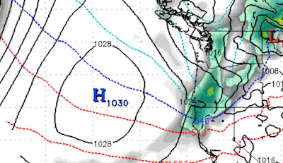
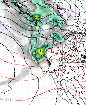
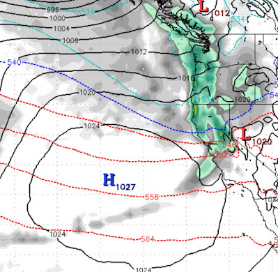
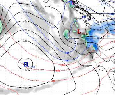
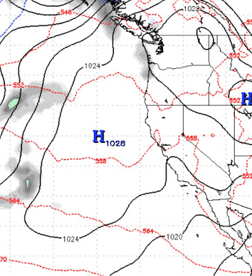
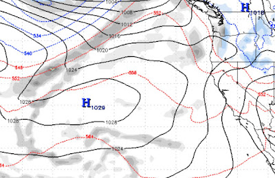
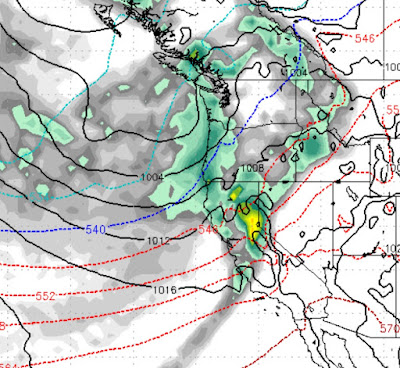
Our weather pattern continues to be active. As high pressures keeps storms north of us, a few of those storms will give us glancing blows. Then on Christmas day, the chance exists for a decent storm. To this point, we have not seen a giant La Nina storm, but we believe that it is coming, probably in January. Here is one of those near misses as a storm delivers us a glancing blow on late Monday / Early Tuesday (12/21), the NWS is more impressed with this storm than we are, so the chance does exist for some accumulation. From what we are seeing, just a few inches of mountain snow at best as the cold front drops temps: Notice the blocking ridge of high pressure. That is going to keep the storms north of us. However, that ridge is going to get knocked south and severely flattened. This will allow storms to drop south and into the Tahoe area. The first of those storms will arrive around Christmas Eve and last through Christmas day: You can see another storm right on the heels of the Christm

Pattern Changed; Next Storm Up

Image
Our weather pattern has taken an about face. The next storm in the series comes in very early Thursday morning. We are expecting another foot of snow for Mt. Rose from this storm as well. These are smaller storms that simply are not indicative of La Nina. Meanwhile our ridge of high pressure is being bounced all over the Pacific. That makes the models change their mind quite frequently. There are still a series of storms stacked up in the Pacific. The models are NOT showing any storms (after Thursday) hitting the Tahoe area until around Christmas. We do not believe that. We think this pattern will continue. For now, this next storm and the past storm should greatly improve skiing conditions. Stay tuned ...

Pattern Change Starts This Weekend

Image
 The pattern change that we have been talking about for the last 3 weeks is finally upon us. We have a series of storms heading to Tahoe. The question that remains; how much snow will these storms bring us? We hope to answer that question. Right now the models are at odds with one another. What does that mean? That means that our confidence of a major weather event over the weekend is not as high as we would like. In fact, the GFS model, has backed off completely on a storm hitting this weekend. It is calling for a glancing blow. The European model, which is more accurate in our opinion, is calling for a moderate snow event for the Tahoe area: The above chart is the forecast for Sunday afternoon as seen through the EC weather model. This should bring some very beneficial snow to Tahoe, but not what we were looking for. The NAM or North American Model, is in agreement with the European model. (Sorry for the confusion) We have a very unstable pattern that we are moving into, so I expect

As Ridge Moves West Expect Major Pattern Change

Image
 The models have been pretty consistent these past few days. Somewhere around the 13th of this month, about a week from today, we expect our blocking ridge of high pressure to move south and west. That will open a storm door and at least for now, it looks like the storms are going to come right in! As with most pattern changes, the storms will start fairly weak and become progressively much stronger. Remember the days when the week of Christmas brought powerful storms into the Tahoe area. Well if things hold together, we are going to have a very stormy several weeks leading up to Christmas. Here is a look at the forecast for the morning of Monday December 14th: This is the weakest storm in the bunch, but notice how the ridge of high pressure is getting pushed south and west! That is very good news. A very large storm is brewing in the Gulf of Alaska. It begins to further flatten the ridge which opens the storm door even further, more very good news. As this very powerful storm pushes e

Pattern Change Could Take Place in 10-12 Days

Image
High Pressure off the West Coast will continue to dominate our weather for at least the next 10 days. However we are seeing the possibility of a pattern change around the 12th of December. Here is what we are up against: The ridge of high pressure is strategically located to block any moisture and keep our temperatures well above normal; a double whammy preventing storms to enter our area and the resorts from making snow.  However, not all is lost. In fact, most Tahoe areas are open and skiing is good for the most part.  We are seeing a pattern change that could arrive in the nick of time: Notice the new location of the ridge of high pressure. That should open a door for storms to make it into our area and if you believe the GFS weather model, a series of storms will slip through that door and bring much needed precip to Tahoe sometime between the 12th - 16th of December. Obviously that is quite a few days in the future and we will need to keep a close on this, but for those who prefer

Storm Machine to Shutdown; Ski Areas May Also

Image
 We are seeing a massive blocking ridge of high pressure setting up just off the West Coast: This ridge of high pressure is going to settle in, push all storms well north of Tahoe and stay there through at least the first week in December. Both the GFS and EC weather models are in agreement, which means the likelihood of this happening is high. Here is a wider look as the ridge in the jet stream sets up: This is a classic La Nina pattern. Having said that, the models have been really struggling with anything more than a few days out this year, so hope is not completely lost. Currently the long range models are showing a sign of the ridge breaking down around the 10th of December. All we can do between now and then is hope that Ma Nature flexes her ample muscles and returns us to the snow. Similar to the weather shutting down, rumor has it that Nevada may be shutting down as well. We certainly hope not as checking the hospital data in both Washoe and Clark counties we are seeing the fol

Storms are Stacking Up

Image
 We continue to see a very active weather pattern for the next several weeks. The models have consolidated. They are backing off on the precip amounts but not by much. 11/17 - 11:00 PM This first storm now finds the EC model a bit more bullish. It is born in the north, is a warmer storm that will pull up sub-tropical moisture from the south. The redlines and blue lines signify the cold front. The further north the redlines are, the warmer the storm. We are guessing around 6,500 to 7,000 feet. So this will be all snow for Mt. Rose. Our best guess is around 12-18 inches. 11/24 A series of smaller events will keep our weather unstable. Then on the 24th or thereabouts, the next storm will arrive. This is a smaller storm, but we have seen this pattern before. We believe this storm is wolf in sheep's clothing and could produce another foot of snow. The final storm we are tracking will arrive around the 28th. This is a much larger storm. We still do not have a clear picture of what this w