Strong Low To Sneak In
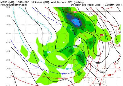
The high pressure ridge which has dominated our weather for nearly a month now is going to drift ever so slightly west, which will allow an unseasonably strong low pressure system to sneak into our area and have an impact on our weather for the next 5 days or so. I understand there is a bike race that goes over the pass between Kings Beach to Northstar tomorrow. There will be snow over that pass tonight through tomorrow morning with 2-6 inches of accumulation likely. At Lake level, the NWS is calling for 1-3 inches, falling late tonight through tomorrow morning. There is not a ton of moisture associated with this storm. This, however, this is a very deep low and the pressure gradient will squeeze out some very strong winds, especially in the Sierra. Those winds will start late this afternoon, peak tonight and remain strong at least through the day tomorrow. Here is a look at the GFS precip forecast for 5:00am tomorrow morning:
Again, not heavy precip, but the timing should guarantee snow for the bikers going over the pass.
This storm will usher in some very cold temperatures as well. Lake Tahoe high temps tomorrow will probably not get out of the 30's. Yes you read that correctly, 30's for highs at the lake on May 15th. It will even be colder in the higher elevations. The leeward valley's highs will peak out in the mid-40's tomorrow. Those same valley's will not see temps out of the 50's until next Thursday.
For you skiers and boarders, expect around 6 inches of snow accumulating in the Sierra, which should make conditions pretty darn good. I am climbing to the top of Slide Mountain and checking it out late morning tomorrow.
Stay Tuned ...
