Posts

Quick Update

Image
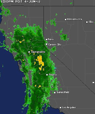
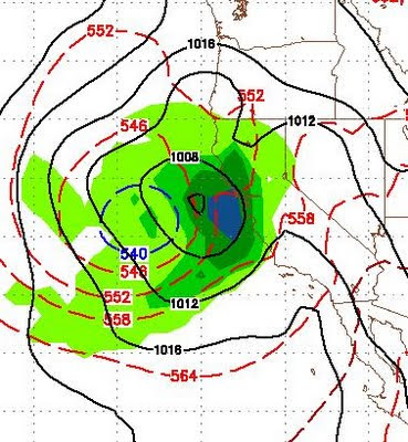
Not much has changed as the large storm is stationary off the Northern/Central California coast. The NWS is increasing it's precip totals in areas further south, which includes the Tahoe Basin. Snow levels should be around 8,000 feet until Sunday night when the real cold air comes in on the back side of the low. They will then drop down to 6,000 feet. The NWS will issue a Winter Weather Advisory for the Sierra Starting very early Monday morning. I am still sticking with my forecast of a major change to a summer pattern coming on the 9th of June. Then by the 16th or 17th, the leeward valley's will be in the upper 80's and low 90's, which is above the average temperature. It will, however, be a slow transition. This final storm of the winter will be very beneficial for the entire area and push back the fire season some 2-4 weeks, as many areas will receive 2-4 inches of rain. Here is a quick look at the regional radar at 1:00 pst today:   This moisture should push no

Huge, Cold, Wet Storm Knocking on the Door

Image
 An unseasonably large storm is gaining strength and knocking on our door. This would be a pretty impressive January storm. It is unheard of for June. It does appear to be the last major storm until next fall. This storm will stick around for the next 4-5 days and drop copious amounts of precip in the region, especially Northern California. Here is a look at the storm as it approaches, this afternoon:    This storm is going to stay stationary for a couple of days and send waves of moisture into California and the Lake Tahoe Basin. Around Sunday evening, it will make it's move and come ashore and track right over Lake Tahoe. Here is a look at early Monday morning (June 6):     Finally, here is a look at the projected precipitation totals. Some parts of California are going to pick up 4+ inches of liquid precipitation. This map has Tahoe in the 1-2 inch range, but I think that is low, especially over the crest of the Sierra, which could be looking at 2-4 feet of snow.     Su

When Will Winter End?

Image
As our temperatures hover around 20 degrees below average and our mountains continue to get pounded with snow, the overwhelming majority of people (including my 9 year old daughter) are asking, "When will winter end?" If you read the links of my last post, you saw that the stars aligned for a very turbulent winter this past year. That weather continues and will continue for about another 7-10 days, at least. About the middle of next week, our temperatures should rebound and get close to average for this time of year. What is happening, is a large area of low pressure to our north continues to cut off pieces of energy and send them our way. The blocking high pressure channels these "cutoff lows" down the coast where they come ashore over Northern California. They bring with them unseasonably cold air. We have another system coming late this weekend with more mountain snow on Sunday night. On it's heels we have another weaker system. The NWS has described this

Not Much Has Changed, Not Much Is Changing

Image
Is This The New Status Quo For you summer enthusiasts, I am not seeing anything on the horizon that will change the weather pattern that we have been in for months. Blocking High Pressure is anchored off the coast to the west. This is a very large area of high pressure. That area needs to move south for our temps to rise. The storms are moving around that area clockwise which is pulling unseasonable cool air in from the north. Occasionally, the ridge slides east and our temps bump into the mid to upper 60's, but then it slides back west and that opens the door for more cooler weather. The long range models are showing no change in our current weather trend. Here is our current situation:   For you drought mongers and global warming enthusiasts your silence in deafening. I have to admit, I do not remember a May like this one. Global Warming, Fact or Fiction You Decide There has never been a better time to start our global warming debate than a 20 degree day with 1-2 feet of sn

Storms Keep Coming

Last night's storm was a little disappointing. However, it appears as though the Northern Carson range may have been the big winner with around 6 inches of snow. Today another storm is on the doorstep and will bring us even more snow. With the big hit coming in late tonight and lasting through tomorrow night. Some areas of the Sierra could pick up another 3 inches of liquid precip on top of the 3 inches they have received since Saturday. The winds are coming too, starting late morning. Looking ahead, Friday will be the only near normal temperature day for the next week or more, as we will remain in this stormy pattern. Another unseasonably large storm is going to slam the Pacific NW and may have an impact on our weather starting Saturday night and lasting through Monday. The blocking ridge of high pressure will try to make a recovery. Looking way ahead, Memorial day weekend looks like a mixed bag with Sunday and Monday being nice with high's in the mid-70's. Saturday co

The Squeeze Is On

Image
As our dominant high pressure system drifts further west, storms are squeezing by it, down the coast and hitting us in Tahoe. Yesterday's storm dumped over a foot in the higher elevations of the Sierra with 6-10 inches in the Carson Range. Two more storms are going to squeeze by until the high pressure system moves back east and blocks the storms again. Here is a look:   I expect another 1-2 feet by the end of Wednesday for the Sierra and very nearly that in the Carson Range as two decent storms are poised to hit the Tahoe area. Here is a look for late tomorrow: One storm hits tonight and another tomorrow night. Tomorrow's storm has even more potential than tonight's which should dump over a foot of snow in the higher elevations.  Some areas are going to pick up nearly 3 inches of liquid precip, which is almost unheard of this time of  year. Here is the precip totals through Wednesday: Snow levels will be right around lake level and these systems will have no signif

Strong Low To Sneak In

Image
The high pressure ridge which has dominated our weather for nearly a month now is going to drift ever so slightly west, which will allow an unseasonably strong low pressure system to sneak into our area and have an impact on our weather for the next 5 days or so. I understand there is a bike race that goes over the pass between Kings Beach to Northstar tomorrow. There will be snow over that pass tonight through tomorrow morning with 2-6 inches of accumulation likely. At Lake level, the NWS is calling for 1-3 inches, falling late tonight through tomorrow morning. There is not a ton of moisture associated with this storm. This, however, this is a very deep low and the pressure gradient will squeeze out some very strong winds, especially in the Sierra. Those winds will start late this afternoon, peak tonight and remain strong at least through the day tomorrow. Here is a look at the GFS precip forecast for 5:00am tomorrow morning: Again, not heavy precip, but the timing should guarantee