Posts

3 Storms All Snow

Image
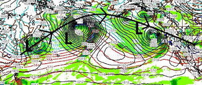
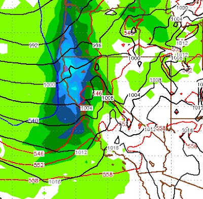
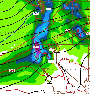
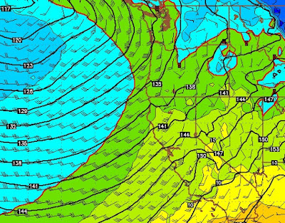
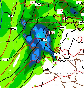
Not much has changed from our forecast. We have 3 storms heading our way. These storms will NOT produce the same amount of precip as that last batch, however they are much cooler and will bring snow all the way to the valley floor. First, here is a look at the storm track: These next 3 storms are taking aim at the Tahoe area. The first storm, will start out a little warmer, but will set the table for the other two storms by pulling cooler air in from the north. Here is a look at the latest forecast for Wednesday afternoon as the storm approaches: The next storm comes in on the heels of this storm, here is a look at very early Friday morning: The last storm in the bunch shows up around Sunday at noon. These storm are coming back to back to back and we will see nearly constant mountain snow above 7,000 feet to start and then lower as that first storm makes its way through. That snow will last nearly an entire week. Precip totals are about what we were predicting with

Storm Machine Starts Up Wednesday

Image
On any other day of any other year we would be talking about a very active storm cycle that will be arriving on Wednesday. However, after 20 feet of snow in just over 8 days it is very difficult to call any storm large again! Having said that, we have a very active weather pattern heading to Tahoe, starting on Wednesday afternoon and lasting for at least a week. These are cooler storms, do not have as much moisture to work with and are moving faster. However, there are at least 3 storms that we are tracking and they will arrive on the heals of their predecessor. First the details: Wednesday Noon through Thursday night (1/18) Friday Noon through Sunday (1/20) Monday Night through Wednesday (1/23) Snow Elevation Right now, it looks like these storms are going to be all snow above 7,000 feet. Each storm will be progressively warmer. I look for snow elevations of the first storm to start around lake level. Impressive at any other time but this one, here are the forecast

Next Storms Arrive on the 18th

Image
Here is all you need to know, there is still a tremendous connection between very warm, moist sub tropical air and Tahoe. Any storm that drops down out of the north is going to tap into that moisture and the storms we have been seeing, may well continue. As this storm winds down on Thursday, we are actually going to see a 4-5 day break. However, we are tracking two large storms. We are still a ways out, so anything can happen, but the models have been scary accurate during this period. Here is a look at the forecast for next Wednesday: This storm is tapping into that moisture plume we are talking about. It will hang around and deliver several waves of very heavy moisture. Right now, we are looking at all snow above 7,000. This storm is born in the north and should bring enough cold air with it, to bring snow levels to reasonable elevation. We say 7,000 now, but that could change. Next, on the heels of this storm is a massive storm, again born in the north but could be a bit

Storm Rages Snow Levels Falling Quickly, Next Storm Much Colder

Image
It would appear as though this storm has peaked out at about 9,000 foot snow elevation. That is now starting to come down and it will plummet to a mixture around 5,000-6,000 feet. That means this is a massive snow storm above 8,000 feet. Again, most other weather outlets can tell you about the flooding, so I will not waste your time here. Next Storm and Beyond Synopsis This storm will finally wind down around 2:00 tomorrow afternoon. Then, 8 hours later the next storm arrives with much colder air. This next storm will tap into a very wet Pacific moisture plume and deliver more large amounts of snow. This storm will wind down on Thursday afternoon after dumping several feet of snow throughout the Sierra, starting at about Lake Level (6,300 feet). After this storm moves on, we foresee about a 4-5 day dry period before another very impressive storm moves in early on Tuesday the 17th of January. The peak of the next storm should hit us Tuesday afternoon and last a good 24 hours. The

Next Storm Comes in Cold Warms Quickly, Tuesday's Storm Much Colder

Image
A near worse case scenario is unfolding for this weekend. A strong, moist storm will begin to hit the Sierra near Tahoe starting early Saturday. That storm will come in cold with snow levels around 5,000-6,000 feet. Then it will quickly turn very warm. I am now thinking we could see heavy rain as high as 10,000 feet for a long period of time from Saturday night through most of the day on Sunday. That is going to cause flooding in the leeward valleys. Here is a look at the forecast temperatures aloft for Sunday afternoon when the storm is raging. Most other weather outlets have now picked up on this. The NWS has issued a flood warning for Reno. The good news is that Tuesdays powerful storm is looking much cooler now. This should be another massive snow event above 7,000 feet. Drought? A quick word about the so called drought. First of all, the drought was busted in the leeward valleys nearly 2 years ago. Our average precip, has been nearly 200%. The mongers are measuring the

Short Break, then Two Large Storms

Image
After an epic dump of snow on all of Tahoe and all Tahoe resorts, we are in the midst of a short break. Do not let this lull fool you, the last storm was the smallest of the three. Actually, while we are at it, we see a fourth storm on the horizon, perhaps 10 days out that looks to be pretty mean as well. But, let's not get ahead of ourselves. This next storm will get cranking Saturday afternoon. We believe it will not stop snowing until the following Friday. That seven days of snow will be mostly very heavy precipitation. I am going to try and pinpoint the peaks of these next two storms. The first storm gets going Saturday, the next storm arrives right on the heels of the first storm around Tuesday noon. Sunday @ Noon: Start of Storm 3 - Tuesday Night Snow Elevations All of these storms will be warmer than the last storm that just hit us. They are larger and are packing subtropical moisture. Trying to forecast snow elevations is very tricky, but because of the size

Major Winter Storms Closing In

Image
If you read my last post, not much has changed. We have 3 major winter storms that are closing in on Tahoe that are going to produce snow like we have not seen in decades. Let's talk a little bit about timing as we have received many comments about how forecasters are saying something one day and completely changing their mind the next. That has not happened here. For a synopsis, here is a link to my last post: Epic January on Tap I strongly suggest that if you are not familiar with this site, you check it out. Unofficial Mt. Rose will give you the details of what is going happening on the mountain: Unofficial Mt. Rose The first storm is knocking on the door and the timing is right on from what we said late Saturday. Here is the forecast for the next 24 hours: There will be a slight break starting late tomorrow that will last until late Saturday morning. Then a massive storm comes to the area that is moisture packed and will effect most of the state of California, wit