Posts

Heavy Sierra Snow Continues Until Wednesday, Then Short Break, Then Another Impressive Storm for Next Weekend

Image
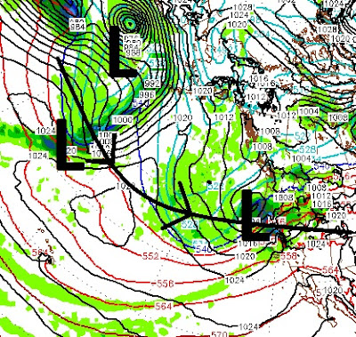
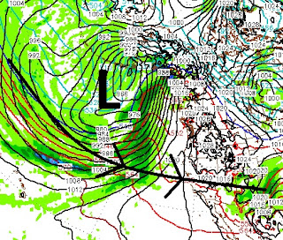
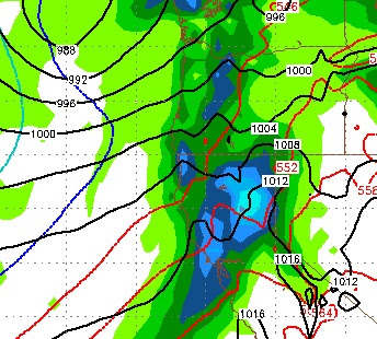
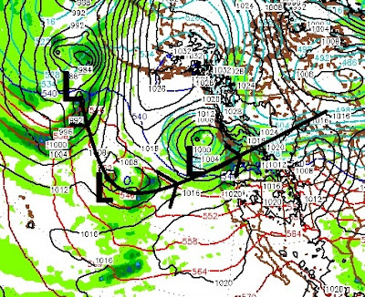
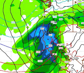
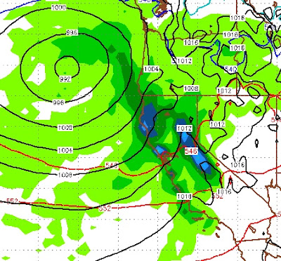
Averages have a way of catching up. We have been saying that for years. Last year we shifted from an extremely dry pattern to an average winter. That trend told us, that those averages were going to start catching up, this year. That is why we predicted an above average snowfall year. We had no idea! This latest storm continues to pound Northern California and the Sierra. It will continue until Wednesday morning then we will have a short drying out. Here is a look at the current conditions: As this latest storm moves inland, it will give way to a drier period. That will last until Saturday afternoon when the next system moves in. That system can be clearly seen along with its path straight to California. Those two storms will eventually become one larger storm. Again, that storm will have a very large moisture tap. Here is a look at the forecast for next Saturday afternoon: Currently, the models are not showing another massive moisture event. However, the scales ha

Deja Vu ... All Over Again

Image
The party gets going again around noon on Thursday. A massive storm which is centered well to our north will spin up at least 5 smaller storms and throw them right into the entire state of California, including Tahoe. Like we have seen for the last month and a half, these storms have plenty of subtropical moisture to work with.  Here is the forecast for Thursday at noon: As these storms tap into the subtropical moisture, they will come in warm. As they exit they will pull down cooler air ... until the next system arrives. So look for around 8,000 feet on this first storm, with snow levels coming down to around 5,500 feet as we get on the back side. Then, late Friday night, we have a split condition. The storm will split with the moisture tap partially broken for Tahoe, but on full display for Central and Southern California: The next storm shows up around Sunday at noon. This storm will pull more air from the north and less from the south, which means fa

Strong, Damaging Winds for Thursday give Way to Heavy Mountain Snow and Valley Rain

Image
The strongest winds of the season are heading our way. They will start up tonight and continue into the afternoon tomorrow. Ridge top winds will exceeed 150mph, while downslope winds for the leeward foothills could see gusts in excess of 100 mph. The next big wave of moisture will start up tomorrow afternoon and with it we will have falling snow levels. I expect Mt. Rose to pick up all snow starting tomorrow afternoon. I expect an additional 2-4 feet of snow by Friday evening. Here is a look at the forecast for tomorrow @ noon: By the time Saturday afternoon rolls around, we will be in the sunshine with above average temps through next Thursday. Then everything changes back! We are tracking several large storms that appear headed right at Tahoe. Here is a look at the forecast for the 16th of February: More impressive is the pattern that is setting up, with a massive storm to the north spinning off waves of smaller storms and sending them straight through Tahoe: The

One More Big Storm, Then at least a 5 Day Break

Image
The biggest change in our forecast certainly has to do with the snow levels. First of all, take a look at what we can expect tomorrow: This storm is packed with moisture. It is arriving on the heels of our last storm so we will continue to see moisture and wind until about next Friday afternoon. This moisture is coming straight from Hawaii and with it will come some very warm air. Much warmer than what we forecast last week. Although snow levels will probably not get much above 8,000 feet, we could see a period of rain on half of Slide Mountain. This is a pure pineapple express, here is a look at the Pineapple Express in its purest form: Pinpointing exact snow levels is very difficult, we believe 8,000 is pretty much as high as the rain will get for any sustained period. However, we could be way off too. If we see rain at 10,000 feet, things could get dicey, especially with all the moisture packed into this storm. I wish I could tell you with certainty what will happen at wha

Several More Storms are Stacked up and Heading Our Way

Image
Here is a look at the current conditions in the Northern Pacific: The current storm should continue to pound us off and on through the night and then to a lesser degree tomorrow and tomorrow night. The Next storm can be seen on the picture above. It will follow a nearly identical path and bring more moisture to the area. Then, on the heels of that storm, another storm will gain strength and follow the nearly identical path. There is copious amounts of moisture in the sub-tropical Pacific for these storms to tap into. I see snow elevations moving down slightly but staying between 5,500 and 7,500 feet. Here is the forecast timing of these events: Early Monday Morning (3:00am) This is the beginning of the second storm of the three we talked about earlier. This will last throughout the day on Monday. We will get a very short break around 2:00am Tuesday morning until about noon on Tuesday, then the same storm will send us a huge wave of moisture. 4:00 Tuesday Afternoon

First Storm Strengthens, Second Storm Takes Aim at Tahoe

Image
If you read our post from a couple of days ago, we talked about two storms. The first of the storms arrives Thursday. That storm looks to be strengthening and will deliver more moisture than we originally anticipated. The 2nd storm looked like it was going to head north of us. That storm now has moved considerably south, and is packed with moisture. It is coming sooner than we anticipated and should arrive very early Monday morning just as our first storm is exiting. Folks, this is starting to look like one of those weeks we had in January. I expect copious amounts of snow to fall in the Sierra and Carson Range, with significant rain hitting the leeward valleys, as much as 1-4 inches depending on your location. Here is a look at the forecast for early Monday morning: This storm has moved so far south that it will have a large effect on Central and parts of Southern California as well. Here is the new total precip forecast: All of the Sierra and Carson range are in th

Move to Stormy Pattern Starts Thursday Morning

Image
High Pressure is dominating our weather with deep valley inversions and beautiful warm mountain days. That is going to come to an end on Thursday morning as a decent sized storm moves in from the west and will bring moderate precipitation to the Sierra and Carson Range. Then, after that storm moves out, an even bigger system it going to move into the area in about 8 days. That system may move north of us, too soon to tell. Here is a look at the first system very early Friday morning when the peak of the precipitation begins: This system will hang around and deliver moderate to heavy precip until around noon on Saturday. Snow levels will start low, rise to around 7,500 feet and then drop as we get on the backside of the front. I do not see any accumulating snow below 6,000 feet. However, we will almost certainly see some rain in the valleys. The higher and further west you are, the more rain you will get. I see the leeward foothills picking up close to an inch. The next system