Posts

20 Feet of Snow in Last Month With More on the Way

Image
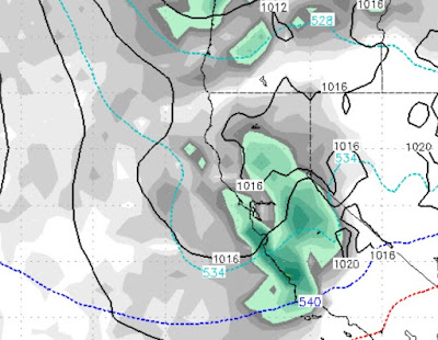
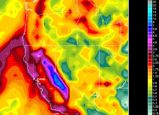
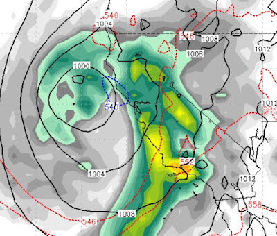
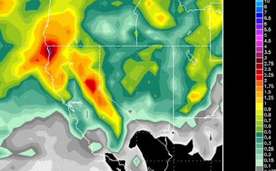
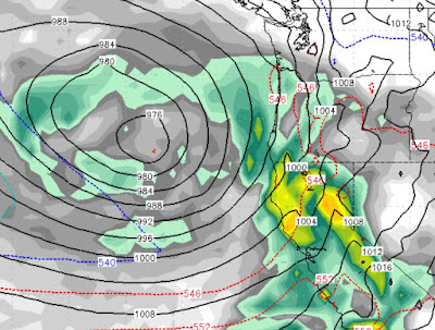
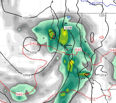
The weather pattern will remain very active with a series of storms bearing down on Tahoe.  Like our last few storms, these storms come in with very cold air and should be all snow for all Tahoe resorts. Remember, the later we get in the season, the tougher it is for storms to get over to our side of the lake. The first of the storms, will be shadowed almost entirely by the Sierra. In fact we are not looking for much precip anywhere, but what little falls, will be at the crest on the other side of the lake. Here is a look at the first storm which will begin to effect the area late Friday night (2/9): : This storm slams into the Sierra and then dips south. However, that will open the door for the next storm to drop in from the north. That storm will show up late Saturday afternoon (2/10) and will impact both sides of the lake: This storm should hang around throughout all of Sunday. The following week has several large storms, that will be warmer, that could bring even more

Storm Update - Leeward Valleys Could See Heavy Snow

For a complete recap of what is going to happen in the Carson Range and Sierra, see the last 2 posts. This update is to warn the folks who live in the leeward valleys (Reno and Carson), that the potential exists for heavy snow starting Sunday afternoon and lasting through Tuesday afternoon. We have seen this pattern before, as a colder storm drops down on a near perfect trajectory to spill over the mountains and into the valley.  The potential exists for 1-3 feet in the foothills and up to a foot on the valley floor. Mt. Rose could see as much as 6-8 feet of snow between now and next Wednesday! These storms will put us over our season average for a 4th straight year. As we like to say, averages have a way of catching up, so enjoy the great skiing and riding conditions! Stay Tuned ...

Storm Strengthens; Puts Tahoe in Cross hair

Image
The end of our dry period is around 24 hours away. We have talked about this storm for a few weeks now and it is shaping up to be a very active 4-day weather event. First, here is the precip forecast: We are now looking at 4-5 inches of liquid for the Carson Range, while the western side of the lake, in the High Sierra could be looking at 7-8 inches of liquid. Areas down around Mammoth could see up to 10 inches of liquid precip. We have bumped up our Carson Range precip totals to 2-5 feet of snow. We are leaning in the 40 inch range, but that could go higher or lower. As far as elevations are concerned, we believe this will be all snow for Mt. Rose. The leading edge of very warm air will see snow levels in the 7,000 foot range, but those will quickly fall all the way down to 4,000 feet by Sunday night. This will be very beneficial for all Tahoe Resorts! The peak of the precip should be all day Saturday. Then a very short break and starting up again Sunday afternoon and las

Winter Returns Friday

Image
As our ridge of high pressure gets kicked back out to sea, a storm door will open and should start Friday afternoon (2/1)  and last through most of the following Monday (2/4) . The peak of the storms should be hitting very early on Saturday morning: After a near miss on Thursday, a much bigger storm should effect the entire state of California. Right now the models have the Central Sierra taking the biggest blow, but I think we will get our fair share. You can see by the image, with the counter clockwise rotation of the low pressure system, warm, moist air will accompany this storm. I expect snow levels to start fairly high (7,500 - 8,000 feet) on Friday. As the storm moves south, it will then drag down some cooler air by Sunday, so I expect snow levels to drop through the event. Here is a look at the precip forecast: The trajectory of the initial storm will be subject to some shadowing, but we still expect the Carson Range to pick up 1-2 feet. Initially, Sierra Cement. B

Final Storm Today, then Dry for 7-10 Days

Image
The final storm in the series of storms will hit today. The trajectory of this storm has improved as the storm will hit Tahoe directly. The storm has ample moisture, will come in warm with snow elevations around 7,500 feet. It is packing a strong cold front that will bring snow all the way to the valley floor by tonight. Here is a look a the precip potential: We are seeing an additional 1-2 feet of snow for Mt. Rose, with other Tahoe areas picking up rain on the lower mountain eventually turning to all snow. With this storm comes gusty winds for the Sierra and Carson range with ridge top winds exceeding 100 mph. After this storm a ridge of high pressure moves in and this storm cycle, for all practical purposes is over. We see dry weather for the next 7-10 days or more. Looking way down the road, the ridge finally breaks down around February 2nd. A couple of storms look to make it into our area sometime around then. Stay Tuned ...

Storms Strengthen; Take Aim at Tahoe

Image
We have two storms that are heading our way. Starting at Tuesday around noon expect near constant snow for at least the next 3 days with near blizzard conditions starting very early on Thursday and lasting through at least the morning. As we have been saying, the first storm stalls out, the 2nd storm slams it. This 2nd storm has a sub-tropical moisture tap and will drop copious amounts of snow on our area with blizzard conditions throughout the Central and Northern Sierra starting late on Wednesday. How much moisture? As with all storms there will be a rain shadow, but I would be surprised if Mt. Rose did not pick up 4+ feet of snow by next Monday, with the upper mountain of Squaw perhaps picking up 7 feet. Snow levels are a bit tricky. Expect all snow with this first system and snow all the way to the valley floor. As the second system moves in, snow levels will quickly rise and could get as high as 8,000 feet. Behind that system is another cold front and those snow leve

The Storms are Stacked

Image
If you read our last post, not much has changed, but we thought we would do a quick update for what is looking to be a very stormy week. We expect several major snow events for the Sierra and Carson Range. The storms will continue to slam into each other which should provide enough momentum for much of that precip to carry over into the leeward valleys, like Reno and Carson City. Timing: The fun starts Tuesday afternoon when a southern born storm heads north through California and slams into Tahoe: That storm will stall out and bring several waves of light to moderate precip to Tahoe. Then, it will get a big push from a much larger storm and we will start to see major precip around Thursday @ noon: In our last post, we talked about the 3rd storm as the wildcard. Right now the models have that storm, which is even larger than the 2nd storm, giving us a glancing blow on late Saturday night (January 19th) or early Sunday morning. That storm is over a week out so it's t