One More Cold Front, Then Big Warm Up
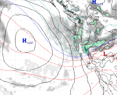
I hope you are enjoying the pleasant morning and early afternoon. But change is a coming! A strong cold front will push down the eastern Sierra in a slider like system. These systems are very hard to predict when it comes to precipitation, but we are thinking less than 6 inches for the Carson Range. Here is the forecast for late to tomorrow night: Notice the very cold air has already pushed through. That will drop our temperatures by 20-30 degrees, at least and plunge us back into the 20-30 degree below average range. The good news: high pressure is going to take over and our temps will quickly recover. We could even see some above average temperatures by next weekend. Here is the forecast for late Friday night (4/7): Notice the warm air stretches all the way up into BC! This should mean some stellar spring skiing conditions for Mt. Rose, probably starting next Thursday. This warm air should stick around until at least the middle of April! Stay Tuned ...